 |
|
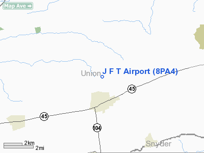
Location & QuickFacts
| FAA Information Effective: | 2008-09-25 |
| Airport Identifier: | 8PA4 |
| Airport Status: | Operational |
| Longitude/Latitude: | 077-02-44.8940W/40-56-40.2940N
-77.045804/40.944526 (Estimated) |
| Elevation: | 660 ft / 201.17 m (Estimated) |
| Land: | 4 acres |
| From nearest city: | 2 nautical miles N of Mifflinburg, PA |
| Location: | Union County, PA |
| Magnetic Variation: | 11W (1990) |
Owner & Manager
| Ownership: | Privately owned |
| Owner: | J F T Airport Inc |
| Address: | Rd 4 Box 202
Mifflinburg, PA 17844 |
| Phone number: | 717-966-3808 |
| Address: |
|
Airport Operations and Facilities
| Airport Use: | Private |
| Wind indicator: | Yes |
| Segmented Circle: | No |
| Control Tower: | No |
| Landing fee charge: | No |
| Sectional chart: | Detroit |
| Region: | AEA - Eastern |
| Boundary ARTCC: | ZNY - New York |
| Tie-in FSS: | IPT - Williamsport |
| FSS on Airport: | No |
| FSS Toll Free: | 1-800-WX-BRIEF |
Airport Communications
Runway Information
Runway 06/24
| Dimension: | 1800 x 100 ft / 548.6 x 30.5 m |
| Surface: | TURF, |
| |
Runway 06 |
Runway 24 |
| Traffic Pattern: | Left | Left |
| Displaced threshold: | 200.00 ft | 0.00 ft |
|
Radio Navigation Aids
| ID |
Type |
Name |
Ch |
Freq |
Var |
Dist |
| PIX | NDB | Picture Rocks | | 344.00 | 09W | 25.1 nm |
| RV | NDB | Stroh | | 407.00 | 10W | 36.5 nm |
| BZJ | NDB | Bellgrove | | 328.00 | 10W | 37.9 nm |
| HXM | NDB | Humbolt | | 366.00 | 10W | 47.7 nm |
| HZL | VOR | Hazleton | | 109.40 | 09W | 41.8 nm |
| FQM | VOR/DME | Williamsport | 091X | 114.40 | 09W | 26.7 nm |
| SFK | VOR/DME | Stonyfork | 023X | 108.60 | 08W | 48.2 nm |
| SEG | VORTAC | Selinsgrove | 041X | 110.40 | 08W | 11.8 nm |
| MIP | VORTAC | Milton | 029X | 109.20 | 09W | 17.9 nm |
| RAV | VORTAC | Ravine | 093X | 114.60 | 11W | 31.1 nm |
| HAR | VORTAC | Harrisburg | 072X | 112.50 | 10W | 38.6 nm |
| PSB | VORTAC | Philipsburg | 102X | 115.50 | 10W | 43.0 nm |
| MDT | VOT | Harrisburg International | | 110.00 | | 46.7 nm |
Remarks
- PRVDD ARPT IS USED DURING VFR WEATHER; LARGEST CLASS OF ACFT USED FOR OPNS IS THE AZTEC ON SENECA TYPE; TREES REMOVED OFF RY 06 TO PROVIDE 20:1 APCH SLOPE.
Images and information placed above are from
http://www.airport-data.com/airport/8PA4/
We thank them for the data!
| General Info
|
| Country |
United States
|
| State |
PENNSYLVANIA
|
| FAA ID |
8PA4
|
| Latitude |
40-56-40.294N
|
| Longitude |
077-02-44.894W
|
| Elevation |
660 feet
|
| Near City |
MIFFLINBURG
|
We don't guarantee the information is fresh and accurate. The data may
be wrong or outdated.
For more up-to-date information please refer to other sources.
|
|


