 |
|
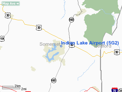
| Indian Lake Airport |
| IATA: none – ICAO: none – FAA LID: 5G2 |
| Summary |
| Airport type |
Closed |
| Owner/Operator |
Indian Lake Airport, Inc. |
| Location |
Indian Lake, Pennsylvania |
| Elevation AMSL |
2,442 ft / 744 m |
| Coordinates |
40°03′20″N 078°50′46″W / 40.05556°N 78.84611°W / 40.05556; -78.84611 |
| Runways |
| Direction |
Length |
Surface |
| ft |
m |
| 14/32 |
4,490 |
1,369 |
Asphalt |
Indian Lake Airport (FAA LID: 5G2) is a privately owned, closed airport located in Indian Lake, Pennsylvania, United States.
The airport was constructed in 1966 to serve the new, growing community of Indian Lake. In its original configuration, it had a single paved northeast-southwest runway (4/22) measuring 3,000 feet (910 m). By 1975, the northwest-southeast runway, 14/32, had been added. The original runway was abandoned by 1993, and the entire airport was closed in 1999. As of 2006, the airport was listed for sale for US$7,000,000.
Accidents
According to FAA records, there has been only one fatal accident involving Indian Lake Airport. On June 13, 1968, a student pilot attempting to land in instrument meteorological conditions crashed north of the airport. The NTSB concluded that the pilot had attempted operation beyond his ability level and experienced spatial disorientation.
The above content comes from Wikipedia and is published under free licenses – click here to read more.
Location & QuickFacts
| FAA Information Effective: | 2008-09-25 |
| Airport Identifier: | 5G2 |
| Airport Status: | Closed Permanently |
| Longitude/Latitude: | 078-50-49.0800W/40-03-15.2840N
-78.846967/40.054246 (Estimated) |
| Elevation: | 2442 ft / 744.32 m (Surveyed) |
| Land: | 63 acres |
| From nearest city: | 4 nautical miles SW of Central City, PA |
| Location: | Somerset County, PA |
| Magnetic Variation: | 08W (1985) |
Owner & Manager
| Ownership: | Privately owned |
| Owner: | Indian Lake Airport, Inc. |
| Address: | Lakeside Building
Central City, PA 15926 |
| Phone number: | 814-754-4634 |
| Manager: | Joseph Markferding |
| Address: | Lakeside Building
Central City, PA 15926 |
| Phone number: | 814-754-4634 |
Airport Operations and Facilities
| Airport Use: | Open to public |
| Wind indicator: | Yes |
| Segmented Circle: | No |
| Control Tower: | No |
| Landing fee charge: | No |
| Sectional chart: | Detroit |
| Region: | AEA - Eastern |
| Boundary ARTCC: | ZOB - Cleveland |
| Tie-in FSS: | AOO - Altoona |
| FSS on Airport: | No |
| FSS Toll Free: | 1-800-WX-BRIEF |
| NOTAMs Facility: | AOO (NOTAM-d service avaliable) |
Airport Communications
Airport Services
| Bottled Oxygen: | NONE |
| Bulk Oxygen: | NONE |
Runway Information
Runway 14/32
| Dimension: | 4490 x 50 ft / 1368.6 x 15.2 m |
| Surface: | ASPH, Good Condition |
| Weight Limit: | Single wheel: 12000 lbs. |
| |
Runway 14 |
Runway 32 |
| Traffic Pattern: | Left | Left |
| Markings: | Basic, Poor Condition
14/32 MARKINGS EXTREMELY FADED. | Basic, Poor Condition |
| Displaced threshold: | 524.00 ft
DSPLCD THR IS APPRX 12 FT ABOVE THR ELEV. | 0.00 ft |
| Obstruction: | 51 ft trees, 393.0 ft from runway, 118 ft right of centerline, 3:1 slope to clear
+52 FT TREES 1165 FT 85 FT R; 22:1 BASED ON DSPLCD THLD. | 19 ft trees, 226.0 ft from runway, 41 ft right of centerline, 1:1 slope to clear
+24 FT TREES AT THLD & 110 FT L; +11 FT TREES 181 FT FROM THLD & 116 FT L; +13 FT RD WITH VEHICLES 134 FT FROM THLD & ON EXTDD CNTRLN. |
|
Radio Navigation Aids
| ID |
Type |
Name |
Ch |
Freq |
Var |
Dist |
| SYS | NDB | Stoystown | | 209.00 | 08W | 3.7 nm |
| CBE | NDB | Cumberland | | 317.00 | 07W | 24.8 nm |
| BHU | NDB | Benje | | 382.00 | 07W | 27.4 nm |
| INP | NDB | Indiana | | 242.00 | 08W | 36.1 nm |
| VV | NDB | Camor | | 299.00 | 08W | 42.6 nm |
| MKP | NDB | Mc Keesport | | 287.00 | 07W | 46.5 nm |
| AOO | VOR | Altoona | | 108.80 | 07W | 29.8 nm |
| GRV | VOR/DME | Grantsville | 070X | 112.30 | 06W | 26.9 nm |
| REC | VOR/DME | Revloc | 043X | 110.60 | 09W | 29.9 nm |
| JST | VORTAC | Johnstown | 077X | 113.00 | 06W | 15.8 nm |
| IHD | VORTAC | Indian Head | 019X | 108.20 | 06W | 24.0 nm |
| THS | VORTAC | St Thomas | 097X | 115.00 | 07W | 41.9 nm |
| TON | VORTAC | Tyrone | 096X | 114.90 | 07W | 47.2 nm |
Remarks
- DEER ON & INVOF ARPT.
- TWY SFCS IN EXTREMELY POOR COND.
- (ARPT STATUS) ARPT CLSD PERMLY.
- VFR OPNS ONLY
Images and information placed above are from
http://www.airport-data.com/airport/5G2/
We thank them for the data!
| General Info
|
| Country |
United States
|
| State |
PENNSYLVANIA
|
| FAA ID |
5G2
|
| Latitude |
40-03-15.284N
|
| Longitude |
078-50-49.080W
|
| Elevation |
2442 feet
|
| Near City |
CENTRAL CITY
|
We don't guarantee the information is fresh and accurate. The data may
be wrong or outdated.
For more up-to-date information please refer to other sources.
|
|


