 |
|
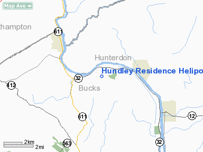
Hundley Residence Heliport |
Location & QuickFacts
| FAA Information Effective: | 2008-09-25 |
| Airport Identifier: | 09PN |
| Airport Status: | Operational |
| Longitude/Latitude: | 075-08-33.6250W/40-33-43.3650N
-75.142674/40.562046 (Estimated) |
| Elevation: | 480 ft / 146.30 m (Estimated) |
| Land: | 0 acres |
| From nearest city: | 3 nautical miles E of Kintersville, PA |
| Location: | Bucks County, PA |
| Magnetic Variation: | 12W (1985) |
Owner & Manager
| Ownership: | Privately owned |
| Owner: | Mr & Mrs Monty D. Hundley |
| Address: | Po Box 22
Bedford, NY 10506-0022 |
| Phone number: | 212-888-7599 |
| Manager: | Mr & Mrs Monty D. Hundley |
| Address: | Woodland Dr
Upper Black Eddy, PA |
Airport Operations and Facilities
| Airport Use: | Private |
| Wind indicator: | Yes |
| Segmented Circle: | Yes |
| Control Tower: | No |
| Lighting Schedule: | DUSK-DAWN
ACTVT FLOOD & PERIMETER LGTS & VASI - 123.3. |
| Beacon Color: | Clear-Green-Yellow (heliport) |
| Sectional chart: | New York |
| Region: | AEA - Eastern |
| Boundary ARTCC: | ZNY - New York |
| Tie-in FSS: | IPT - Williamsport |
| FSS Toll Free: | 1-800-WX-BRIEF |
Runway Information
Helipad H1
| Dimension: | 30 x 30 ft / 9.1 x 9.1 m |
| Surface: | CONC, |
| |
Runway H1 |
Runway |
| Traffic Pattern: | Left | Left |
| VASI: | nonstandard system | |
|
Radio Navigation Aids
| ID |
Type |
Name |
Ch |
Freq |
Var |
Dist |
| EWR | FAN MARKER | Maryann | | | 11W | 44.4 nm |
| UKT | NDB | Quakertown | | 208.00 | 12W | 10.9 nm |
| DYL | NDB | Doylestown | | 237.00 | 10W | 13.6 nm |
| NXX | NDB | Willow Grove | | 388.00 | 12W | 22.4 nm |
| ING | NDB | Ambler | | 275.00 | 11W | 27.0 nm |
| LQX | NDB | Carbon | | 339.00 | 12W | 31.9 nm |
| CAT | NDB | Chatham | | 254.00 | 11W | 34.2 nm |
| HXM | NDB | Humbolt | | 366.00 | 10W | 46.6 nm |
| NEL | NDB | Lakehurst | | 396.00 | 13W | 48.3 nm |
| CYE | NDB | Crystal Lake | | 410.00 | 11W | 50.0 nm |
| NXX | TACAN | Willow Grove | 061X | | 10W | 22.1 nm |
| NEL | TACAN | Lakehurst | 055X | | 11W | 48.0 nm |
| NEL | UHF/NDB | Lakehurst | | 274.80 | 13W | 48.3 nm |
| PNE | VOR | North Philadelphia | | 112.00 | 10W | 29.5 nm |
| CKZ | VOR/DME | Pennridge | 025Y | 108.85 | 12W | 12.3 nm |
| SBJ | VOR/DME | Solberg | 076X | 112.90 | 10W | 18.3 nm |
| BWZ | VOR/DME | Broadway | 089X | 114.20 | 11W | 20.4 nm |
| ARD | VOR/DME | Yardley | 019X | 108.20 | 10W | 21.4 nm |
| ETX | VOR/DME | East Texas | 039X | 110.20 | 09W | 24.7 nm |
| STW | VOR/DME | Stillwater | 033X | 109.60 | 11W | 28.9 nm |
| COL | VOR/DME | Colts Neck | 101X | 115.40 | 11W | 47.4 nm |
| FJC | VORTAC | Allentown | 122X | 117.50 | 10W | 17.3 nm |
| PTW | VORTAC | Pottstown | 112X | 116.50 | 09W | 28.0 nm |
| RBV | VORTAC | Robbinsville | 085X | 113.80 | 10W | 36.7 nm |
| SAX | VORTAC | Sparta | 104X | 115.70 | 11W | 41.0 nm |
| GXU | VORTAC | Mc Guire | 043X | 110.60 | 11W | 41.6 nm |
| MXE | VORTAC | Modena | 079X | 113.20 | 09W | 45.7 nm |
| LVZ | VORTAC | Wilkes-barre | 053X | 111.60 | 10W | 49.4 nm |
| PHL | VOT | Philadelphia Intl | | 109.80 | | 41.8 nm |
Remarks
- PRVDD HEDGE ROW TO THE NORTH BE REMOVED.
Images and information placed above are from
http://www.airport-data.com/airport/09PN/
We thank them for the data!
| General Info
|
| Country |
United States
|
| State |
PENNSYLVANIA
|
| FAA ID |
09PN
|
| Latitude |
40-33-43.365N
|
| Longitude |
075-08-33.625W
|
| Elevation |
480 feet
|
| Near City |
KINTERSVILLE
|
We don't guarantee the information is fresh and accurate. The data may
be wrong or outdated.
For more up-to-date information please refer to other sources.
|
|


