 |
|
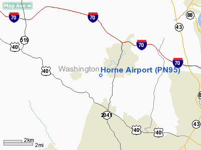
Location & QuickFacts
| FAA Information Effective: | 2008-09-25 |
| Airport Identifier: | PN95 |
| Airport Status: | Operational |
| Longitude/Latitude: | 080-01-59.1910W/40-06-00.2590N
-80.033109/40.100072 (Estimated) |
| Elevation: | 1040 ft / 316.99 m (Estimated) |
| Land: | 0 acres |
| From nearest city: | 0 nautical miles of Scenery Hill, PA |
| Location: | Washington County, PA |
| Magnetic Variation: | 07W (1985) |
Owner & Manager
| Ownership: | Privately owned |
| Owner: | Byron W Horne |
| Address: | Box 128,
Scenery Hill, PA 15360 |
| Phone number: | 412-945-6516 |
| Manager: | Byron W Horne |
| Address: | Box 128
Scenery Hill, PA 15360 |
| Phone number: | 412-945-6516 |
Airport Operations and Facilities
| Airport Use: | Private |
| Segmented Circle: | No |
| Control Tower: | No |
| Landing fee charge: | No |
| Sectional chart: | Detroit |
| Region: | AEA - Eastern |
| Boundary ARTCC: | ZOB - Cleveland |
| Tie-in FSS: | AOO - Altoona |
| FSS on Airport: | No |
| FSS Toll Free: | 1-800-WX-BRIEF |
Airport Services
| Airframe Repair: | NONE |
| Power Plant Repair: | NONE |
Runway Information
Runway E/W
| Dimension: | 1300 x 200 ft / 396.2 x 61.0 m |
| Surface: | TURF, |
| |
Runway E |
Runway W |
| Traffic Pattern: | Left | Left |
| Runway End Identifier: | No | No |
| Centerline Lights: | No | No |
| Touchdown Lights: | No | No |
|
Radio Navigation Aids
| ID |
Type |
Name |
Ch |
Freq |
Var |
Dist |
| PNU | NDB | Washington County | | 255.00 | 08W | 6.5 nm |
| VV | NDB | Camor | | 299.00 | 08W | 18.6 nm |
| MKP | NDB | Mc Keesport | | 287.00 | 07W | 19.2 nm |
| BHU | NDB | Benje | | 382.00 | 07W | 38.7 nm |
| CFX | NDB | Cadiz | | 239.00 | 07W | 45.8 nm |
| AGC | VOR/DME | Allegheny | 037X | 110.00 | 09W | 10.7 nm |
| HLG | VOR/DME | Wheeling | 059X | 112.20 | 07W | 26.4 nm |
| AIR | VOR/DME | Bellaire | 118X | 117.10 | 07W | 36.4 nm |
| MMJ | VORTAC | Montour | 057X | 112.00 | 08W | 24.5 nm |
| IHD | VORTAC | Indian Head | 019X | 108.20 | 06W | 32.0 nm |
| MGW | VORTAC | Morgantown | 053X | 111.60 | 05W | 33.6 nm |
| EWC | VORTAC | Ellwood City | 105X | 115.80 | 08W | 44.3 nm |
Remarks
Images and information placed above are from
http://www.airport-data.com/airport/PN95/
We thank them for the data!
| General Info
|
| Country |
United States
|
| State |
PENNSYLVANIA
|
| FAA ID |
PN95
|
| Latitude |
40-06-00.259N
|
| Longitude |
080-01-59.191W
|
| Elevation |
1040 feet
|
| Near City |
SCENERY HILL
|
We don't guarantee the information is fresh and accurate. The data may
be wrong or outdated.
For more up-to-date information please refer to other sources.
|
|


