 |
|
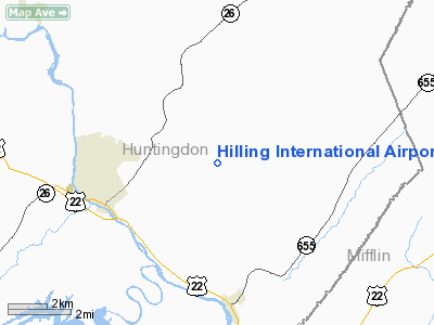
Location & QuickFacts
| FAA Information Effective: | 2008-09-25 |
| Airport Identifier: | PN64 |
| Airport Status: | Operational |
| Longitude/Latitude: | 077-56-21.7000W/40-30-08.6000N
-77.939361/40.502389 (Estimated) |
| Elevation: | 1400 ft / 426.72 m (Estimated) |
| Land: | 0 acres |
| From nearest city: | 4 nautical miles E of Huntingdon, PA |
| Location: | Huntingdon County, PA |
| Magnetic Variation: | () |
Owner & Manager
| Ownership: | Privately owned |
| Owner: | Wm. C. Hilling |
| Address: | 9181 Schoolhouse Hollow Rd
Huntingdon, PA 16652 |
| Phone number: | 814-643-6968 |
| Manager: | Wm. C. Hilling |
| Address: | 9181 Schoolhouse Hollow Rd
Huntingdon, PA 16652 |
| Phone number: | 814-643-6968 |
Airport Operations and Facilities
| Airport Use: | Private |
| Segmented Circle: | No |
| Control Tower: | No |
| Region: | AEA - Eastern |
| Boundary ARTCC: | ZOB - Cleveland |
| Tie-in FSS: | AOO - Altoona |
| FSS Toll Free: | 1-800-WX-BRIEF |
Runway Information
Runway 02/20
| Dimension: | 1280 x 80 ft / 390.1 x 24.4 m |
| Surface: | TURF, |
| |
Runway 02 |
Runway 20 |
| Traffic Pattern: | Left | Left |
| Displaced threshold: | 15.00 ft | 70.00 ft |
|
Radio Navigation Aids
| ID |
Type |
Name |
Ch |
Freq |
Var |
Dist |
| RV | NDB | Stroh | | 407.00 | 10W | 12.2 nm |
| AOO | VOR | Altoona | | 108.80 | 07W | 19.8 nm |
| HGR | VOR | Hagerstown | | 109.80 | 07W | 48.5 nm |
| REC | VOR/DME | Revloc | 043X | 110.60 | 09W | 37.0 nm |
| TON | VORTAC | Tyrone | 096X | 114.90 | 07W | 22.7 nm |
| PSB | VORTAC | Philipsburg | 102X | 115.50 | 10W | 25.0 nm |
| THS | VORTAC | St Thomas | 097X | 115.00 | 07W | 34.2 nm |
| HAR | VORTAC | Harrisburg | 072X | 112.50 | 10W | 41.6 nm |
| JST | VORTAC | Johnstown | 077X | 113.00 | 06W | 42.4 nm |
| ETG | VORTAC | Keating | 107X | 116.00 | 10W | 43.8 nm |
Images and information placed above are from
http://www.airport-data.com/airport/PN64/
We thank them for the data!
|
|


