 |
|
Location & QuickFacts
| FAA Information Effective: | 2008-09-25 |
| Airport Identifier: | PA22 |
| Airport Status: | Operational |
| Longitude/Latitude: | 080-25-20.2440W/41-12-05.2050N
-80.422290/41.201446 (Estimated) |
| Elevation: | 1100 ft / 335.28 m (Surveyed) |
| Land: | 140 acres |
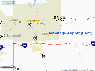
| From nearest city: | 3 nautical miles SE of Sharon, PA |
| Location: | Mercer County, PA |
| Magnetic Variation: | 08W (1985) |
Owner & Manager
| Ownership: | Privately owned |
| Owner: | Buhl R. Clarke |
| Address: | 2578 Frampton Rd
West Middlesex, PA 16159 |
| Phone number: | 412-983-1869 |
| Manager: | Buhl R. Clarke |
| Address: | 2578 Frampton Rd
West Middlesex, PA 16159 |
| Phone number: | 412-983-1869 |
Airport Operations and Facilities
| Airport Use: | Private |
| Wind indicator: | Yes |
| Segmented Circle: | Yes |
| Control Tower: | No |
| Landing fee charge: | No |
| Sectional chart: | Detroit |
| Region: | AEA - Eastern |
| Boundary ARTCC: | ZOB - Cleveland |
| Tie-in FSS: | AOO - Altoona |
| FSS on Airport: | No |
| FSS Toll Free: | 1-800-WX-BRIEF |
Airport Services
| Fuel available: | 100 80 |
| Airframe Repair: | NONE |
| Bottled Oxygen: | NONE |
| Bulk Oxygen: | NONE |
Runway Information
Runway 18/36
| Dimension: | 2110 x 65 ft / 643.1 x 19.8 m
30' ROLLED CINDER CENTER SECTION/TURF POOR CONDITION/MANY LOOSE STONES AND CINDERS. |
| Surface: | TURF-GRVL, Poor Condition |
| |
Runway 18 |
Runway 36 |
| Traffic Pattern: | Left | Left |
| Markings: | None, | None, |
| Runway End Identifier: | No | No |
| Touchdown Lights: | No | No |
| Obstruction: | 65 ft tree, 20.0 ft from runway, 70 ft right of centerline, 1:1 slope to clear | 40 ft tree, 50.0 ft from runway, 120 ft right of centerline, 1:1 slope to clear |
|
Radio Navigation Aids
| ID |
Type |
Name |
Ch |
Freq |
Var |
Dist |
| HBD | NDB | Hubbard | | 408.00 | 08W | 5.7 nm |
| UCP | NDB | Castle | | 272.00 | 09W | 10.7 nm |
| AK | NDB | Akron | | 362.00 | 07W | 44.4 nm |
| TSO | NDB | Tolson | | 395.00 | 07W | 48.6 nm |
| FKL | VOR | Franklin | | 109.60 | 06W | 29.2 nm |
| ACO | VOR/DME | Akron | 091X | 114.40 | 04W | 35.7 nm |
| JFN | VOR/DME | Jefferson | 099X | 115.20 | 05W | 36.6 nm |
| CXR | VOR/DME | Chardon | 074X | 112.70 | 05W | 38.4 nm |
| CIP | VOR/DME | Clarion | 076X | 112.90 | 06W | 43.8 nm |
| YNG | VORTAC | Youngstown | 027X | 109.00 | 05W | 13.8 nm |
| EWC | VORTAC | Ellwood City | 105X | 115.80 | 08W | 24.6 nm |
| MMJ | VORTAC | Montour | 057X | 112.00 | 08W | 44.1 nm |
| ERI | VORTAC | Erie | 031X | 109.40 | 06W | 49.4 nm |
| CAK | VOT | Akron/canton Regional | | 110.60 | | 49.3 nm |
Remarks
Images and information placed above are from
http://www.airport-data.com/airport/PA22/
We thank them for the data!
| General Info
|
| Country |
United States
|
| State |
PENNSYLVANIA
|
| FAA ID |
PA22
|
| Latitude |
41-12-05.205N
|
| Longitude |
080-25-20.244W
|
| Elevation |
1100 feet
|
| Near City |
SHARON
|
We don't guarantee the information is fresh and accurate. The data may
be wrong or outdated.
For more up-to-date information please refer to other sources.
|
|


