 |
|
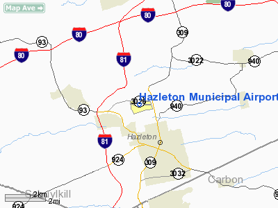
| Hazleton Municipal Airport |
| IATA: HZL – ICAO: KHZL – FAA LID: HZL |
| Summary |
| Airport type |
Public |
| Owner |
City of Hazleton |
| Serves |
Hazleton, Pennsylvania |
| Elevation AMSL |
1,603 ft / 489 m |
| Coordinates |
40°59′12″N 075°59′42″W / 40.98667°N 75.995°W / 40.98667; -75.995 |
| Runways |
| Direction |
Length |
Surface |
| ft |
m |
| 10/28 |
4,898 |
1,493 |
Asphalt |
| Statistics (2008) |
| Aircraft operations |
23,942 |
| Based aircraft |
42 |
| Source: Federal Aviation Administration |
Hazleton Municipal Airport (IATA: HZL, ICAO: KHZL, FAA LID: HZL) is a public use airport in Luzerne County, Pennsylvania, United States. It is owned by the City of Hazleton and located two nautical miles (3.7 km) northwest of its central business district.
The airport was once served by commercial air service on Air Pennsylvania with service to Philadelphia.
Facilities and aircraft
Hazleton Municipal Airport covers an area of 550 acres (223 ha) at an elevation of 1,603 feet (489 m) above mean sea level. It has one asphalt paved runway designated 10/28 which measures 4,898 by 100 feet (1,493 x 30 m).
For the 12-month period ending October 21, 2008, the airport had 23,942 aircraft operations, an average of 65 per day: 99% general aviation and 1% military. At that time there were 42 aircraft based at this airport: 86% single-engine, 2% multi-engine, 5% jet and 7% helicopter.
The above content comes from Wikipedia and is published under free licenses – click here to read more.
Location & QuickFacts
| FAA Information Effective: | 2008-09-25 |
| Airport Identifier: | HZL |
| Airport Status: | Operational |
| Longitude/Latitude: | 075-59-41.6000W/40-59-12.4000N
-75.994889/40.986778 (Estimated) |
| Elevation: | 1603 ft / 488.59 m (Surveyed) |
| Land: | 550 acres |
| From nearest city: | 2 nautical miles NW of Hazleton, PA |
| Location: | Luzerne County, PA |
| Magnetic Variation: | 10W (1980) |
Owner & Manager
| Ownership: | Publicly owned |
| Owner: | City Of Hazleton |
| Address: | 40 N Church St
Hazleton, PA 18201 |
| Phone number: | 570-459-4915 |
| Manager: | Al Roman |
| Address: | Rr 1 - Box 200
Hazleton, PA 18201 |
| Phone number: | 570-454-1560 |
Airport Operations and Facilities
| Airport Use: | Open to public |
| Wind indicator: | Yes |
| Segmented Circle: | Yes |
| Control Tower: | No |
| Lighting Schedule: | DUSK-DAWN
ACTVT MIRL RY 10/28; REIL RY 10; VASI RYS 10 & 28; MALS RY 28 - CTAF. |
| Beacon Color: | Clear-Green (lighted land airport) |
| Landing fee charge: | Yes |
| Sectional chart: | New York |
| Region: | AEA - Eastern |
| Boundary ARTCC: | ZNY - New York |
| Tie-in FSS: | IPT - Williamsport |
| FSS on Airport: | No |
| FSS Toll Free: | 1-800-WX-BRIEF |
| NOTAMs Facility: | IPT (NOTAM-d service avaliable) |
| Federal Agreements: | NGY |
Airport Communications
| CTAF: | 123.000 |
| Unicom: | 123.000 |
Airport Services
| Fuel available: | 100LLA
FUEL SVC AFTER HRS BY PRIOR REQUEST 570-455-7641. |
| Airframe Repair: | MAJOR |
| Power Plant Repair: | MAJOR |
| Bottled Oxygen: | NONE |
| Bulk Oxygen: | NONE |
Runway Information
Runway 10/28
| Dimension: | 4898 x 100 ft / 1492.9 x 30.5 m |
| Surface: | ASPH, Fair Condition |
| Weight Limit: | Single wheel: 47000 lbs.
Dual wheel: 74000 lbs. |
| Edge Lights: | Medium |
| |
Runway 10 |
Runway 28 |
| Longitude: | 076-00-13.4507W | 075-59-09.7499W |
| Latitude: | 40-59-14.1587N | 40-59-10.6827N |
| Elevation: | 1595.00 ft | 1595.00 ft |
| Alignment: | 94 | 127 |
| ILS Type: | | LOCALIZER
|
| Traffic Pattern: | Left | Right |
| Markings: | Non-precision instrument, Good Condition | Non-precision instrument, Good Condition |
| Crossing Height: | 56.00 ft | 0.00 ft |
| VASI: | 4-box on left side | 2-box on right side |
| Visual Glide Angle: | 3.30° | 0.00° |
| Approach lights: | | MALS |
| Runway End Identifier: | Yes | No |
| Centerline Lights: | No | No |
| Touchdown Lights: | No | No |
| Obstruction: | 88 ft trees, 2772.0 ft from runway, 389 ft right of centerline, 29:1 slope to clear | 81 ft trees, 1389.0 ft from runway, 422 ft right of centerline, 14:1 slope to clear |
|
Radio Navigation Aids
| ID |
Type |
Name |
Ch |
Freq |
Var |
Dist |
| HXM | NDB | Humbolt | | 366.00 | 10W | 0.1 nm |
| LQX | NDB | Carbon | | 339.00 | 12W | 15.0 nm |
| CYE | NDB | Crystal Lake | | 410.00 | 11W | 15.3 nm |
| PIX | NDB | Picture Rocks | | 344.00 | 09W | 36.8 nm |
| BZJ | NDB | Bellgrove | | 328.00 | 10W | 41.7 nm |
| UKT | NDB | Quakertown | | 208.00 | 12W | 46.4 nm |
| HZL | VOR | Hazleton | | 109.40 | 09W | 6.0 nm |
| ETX | VOR/DME | East Texas | 039X | 110.20 | 09W | 28.2 nm |
| FQM | VOR/DME | Williamsport | 091X | 114.40 | 09W | 41.1 nm |
| CKZ | VOR/DME | Pennridge | 025Y | 108.85 | 12W | 48.2 nm |
| LVZ | VORTAC | Wilkes-barre | 053X | 111.60 | 10W | 22.1 nm |
| FJC | VORTAC | Allentown | 122X | 117.50 | 10W | 29.1 nm |
| MIP | VORTAC | Milton | 029X | 109.20 | 09W | 30.5 nm |
| LHY | VORTAC | Lake Henry | 045X | 110.80 | 10W | 37.4 nm |
| RAV | VORTAC | Ravine | 093X | 114.60 | 11W | 37.9 nm |
| SEG | VORTAC | Selinsgrove | 041X | 110.40 | 08W | 42.1 nm |
Remarks
- COMPUTERIZED WEATHER INFO AVAIL--MODEM ACCESS 570-655-3911.
Images and information placed above are from
http://www.airport-data.com/airport/HZL/
We thank them for the data!
| General Info
|
| Country |
United States
|
| State |
PENNSYLVANIA
|
| FAA ID |
HZL
|
| Latitude |
40-59-12.400N
|
| Longitude |
075-59-41.600W
|
| Elevation |
1603 feet
|
| Near City |
HAZLETON
|
We don't guarantee the information is fresh and accurate. The data may
be wrong or outdated.
For more up-to-date information please refer to other sources.
|
|


