|
 |
|
||||
|
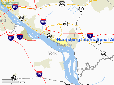
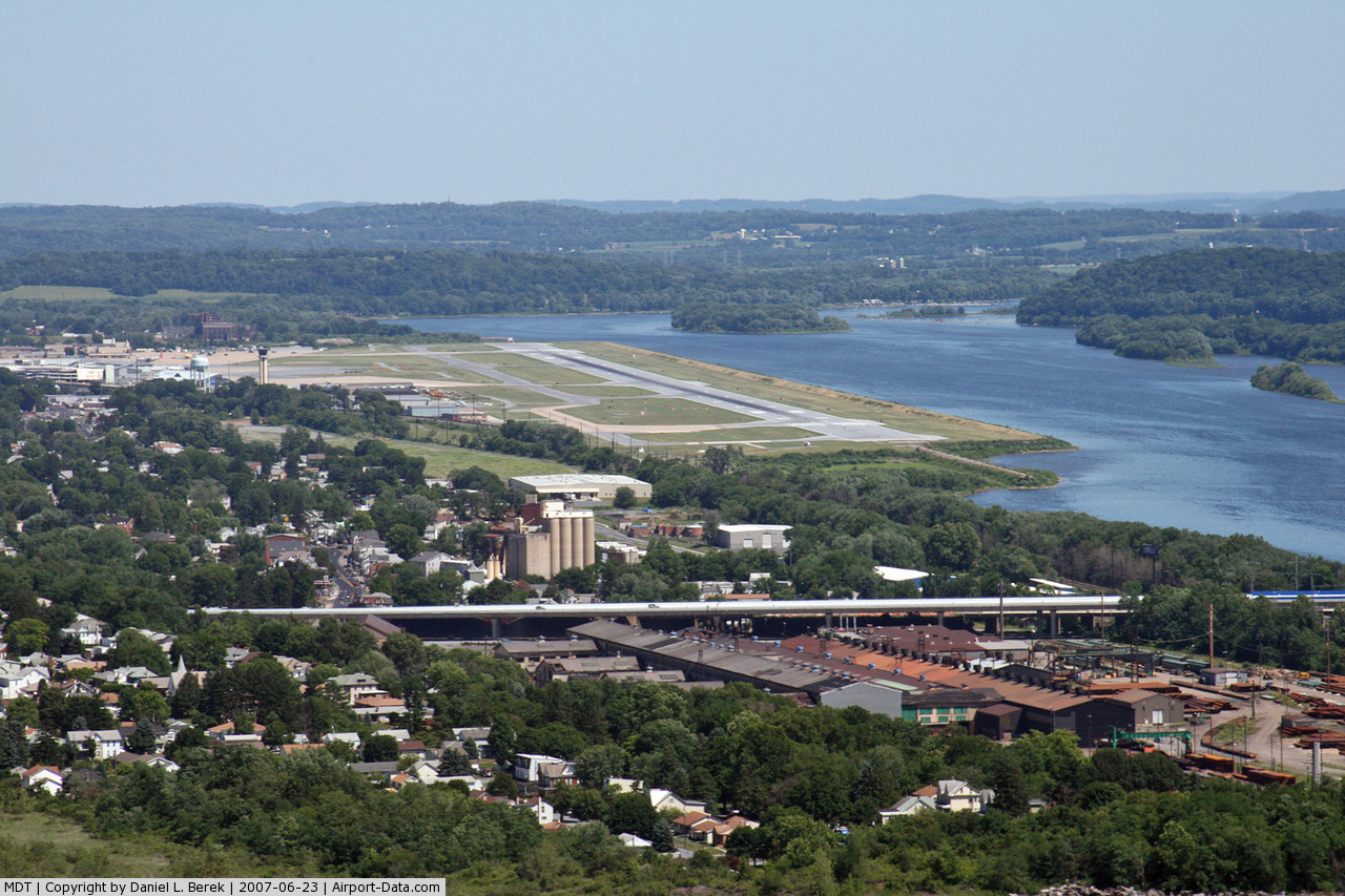
Harrisburg International Airport (IATA: MDT, ICAO: KMDT, FAA LID: MDT) is a public use airport located in Lower Swatara Township, Pennsylvania, eight nautical miles (15 km) southeast of the central business district of Harrisburg. It is owned by the Susquehanna Area Regional Airport Authority. The airport code MDT is a reference to the surrounding community of Middletown, which is a suburb of Harrisburg. Planes landing at MDT from the south are often routed near or over Three Mile Island, only a few miles from the airport. The airport, frequently referred to as HIA, is the primary commercial service airport in South Central Pennsylvania and ranks as the 3rd busiest airport in Pennsylvania for both passenger enplanements and cargo shipments behind Philadelphia International Airport and Pittsburgh International Airport. HistoryHarrisburg International Airport has been serving south-central Pennsylvania for over 100 years. Beginning in 1898, the Signal Corps of the U.S. Army was stationed here. This was followed by the first military airplanes landing in 1918 at what had become Olmsted Field of the fledgling U.S. Army Air Service. The Middletown Air Depot (later Middletown Air Materiel Area) at Olmsted provided logistical and maintenance support of military aircraft until it was closed in 1969. With the turnover from the U.S. Air Force, commercial airline flights were switched from the Capital City Airport to the new Harrisburg International Airport which was established at the former Air Force Base. Architect William Pereira designed the new terminals which were completed in 1973. In 1998, the Commonwealth transferred ownership to the Susquehanna Area Regional Airport Authority (SARAA). The Authority board consists of community volunteers appointed to staggered, five-year terms by the elected officials from Cumberland, Dauphin, and York counties, the cities of Harrisburg and York, and Fairview and Lower Swatara townships. Approximately 1,400 people work in the airport system of Harrisburg International Airport. Facilities and aircraftHarrisburg International Airport covers an area of 680 acres (275 ha) at an elevation of 310 feet (94 m) above mean sea level. It has one asphalt paved runway designated 13/31 and measuring 10,001 by 200 feet (3,048 x 61 m). Runway 13 is equipped with a CAT III approach allowing operations down to 600 ft RVR (Runway Visual Range). The airport is also equipped with a Surface Movement Guidance Control System (SMGCS) that allows for aircraft and vehicle ground movements during reduced visibility specifically below 1200 ft RVR down to 600 ft RVR. For the 12-month period ending December 31, 2005, the airport had 71,190 aircraft operations, an average of 195 per day: 54% air taxi, 22% general aviation, 13% scheduled commercial and 12% military. At that time there were 29 aircraft based at this airport: 17% single-engine, 28% multi-engine, 31% jet, 3% helicopter and 21% military. Ground TransportationBuilt in 2004, and attached to the new terminal building via a climate-controlled sky bridge, the Multi-Modal Transportation Facility (MMTF) is a four-story facility that handles all forms of ground transportation. The top three levels provide 2,504 parking places for Short-Term Hourly, Daily, and Long-Term public parking. The first level accommodates all limos, taxis, hotel shuttles, public and charter buses, plus the rental car ready/return lot. Inside the first floor lobby area, travelers can access six rental car counters, restrooms, flight, and bus information displays, and a seating area. On the second floor of the lobby area, climate-controlled moving sidewalks connect to the aerial walkway which leads directly into the terminal building. Route 7 of the Capital Area Transit System provides bus transportation to and from downtown Harrisburg and surrounding communities. A new rail terminal is proposed for construction adjacent to the MMTF and will provide Amtrak service via the high-speed Northeast and Keystone corridors. CorridorOne, a commuter rail system serving the Harrisburg metropolitan area, is scheduled to provide service starting in 2010. Airlines and destinations
Air CargoHarrisburg International Airport is well positioned with freight-forwarding capabilities. The airport is located adjacent to I-76 (Pennsylvania Turnpike), I-83, and I-81, allowing for fast air-to-ground transfer of goods and commodities. Three major air cargo shippers also maintain air service at the east end of the airport, in a dedicated apron area adjacent to the runway. They are:
Pennsylvania Air National Guard useDespite the closure of Olmsted AFB in 1969, the US Air Force continues to maintain an Air National Guard presence at Harrisburg International Airport in the form of Harrisburg Air National Guard Station and the Pennsylvania Air National Guard's 193rd Special Operations Wing (193 SOW), an Air Force Special Operations Command (AFSOC)-gained unit flying the EC-130 Commando Solo aircraft. The 193 SOW is the sole operator of this critical aircraft asset for the entire US Air Force and in 2001 transitioned from the EC-130E to the new EC-130J variant. The wing has seen extensive Federal service in recent years in support of Operations Just Cause, Desert Storm, Enduring Freedom and Iraqi Freedom. Harrisburg International Airport also remains an active touch and go practice runway for SAM 28000 and SAM 29000. These two planes are used to carry the President when he needs to travel via air. They are also known as Air Force One, the call which is adopted when the president is aboard either aircraft (or any other Air Force aircraft for that matter). The Air Force pilots use the custom VE-25's (Boeing 747s) to practice via touch and go at the airport. These practice runs are at random (for obvious security reasons), but they do tend to be seen at around a weekly rate. The Air Force chooses to use HIA as the practice airport for a number of reasons, mostly because of its relatively long runway (able to land and take off a fully loaded 747), relatively low amount of traffic, its close proximity to Andrews Air Force Base, and the presence of the Air National Guard at HIA. The above content comes from Wikipedia and is published under free licenses – click here to read more.
Location & QuickFacts
Owner & Manager
Airport Operations and Facilities
Airport Services
Runway InformationRunway 13/31
Radio Navigation Aids
Remarks
Images and information placed above are from We thank them for the data!
We don't guarantee the information is fresh and accurate. The data may
be wrong or outdated.
|
||||||||||||||||||||||||||||||||||||||||||||||||||||||||||||||||||||||||||||||||||||||||||||||||||||||||||||||||||||||||||||||||||||||||||||||||||||||||||||||||||||||||||||||||||||||||||||||||||||||||||||||||||||||||||||||||||||||||||||||||||||||||||||||||||||||||||||||||||||||||||||||||||||||||||||||||||||||||||||

 |
|
Copyright 2004-2026 © by Airports-Worldwide.com, Vyshenskoho st. 36, Lviv 79010, Ukraine Legal Disclaimer |