 |
|
 |
(Click on the photo to enlarge) |
Location & QuickFacts
| FAA Information Effective: | 2008-09-25 |
| Airport Identifier: | 1PS7 |
| Airport Status: | Operational |
| Longitude/Latitude: | 075-09-45.6400W/39-57-25.4050N
-75.162678/39.957057 (Estimated) |
| Elevation: | 166 ft / 50.60 m (Estimated) |
| Land: | 0 acres |
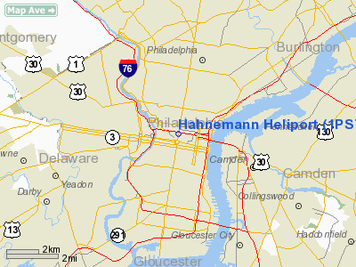
| From nearest city: | 0 nautical miles N of Philadelphia, PA |
| Location: | Philadelphia County, PA |
| Magnetic Variation: | 11W (1980) |
Owner & Manager
| Ownership: | Privately owned |
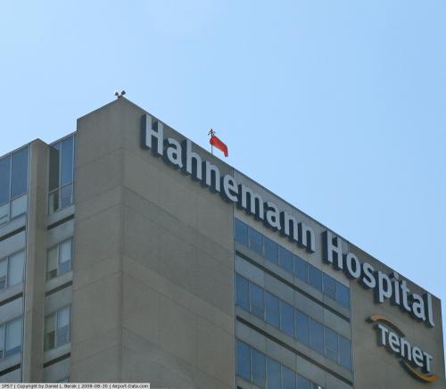
| Owner: | Hahnemann University Hospital |
| Address: | Broad & Vine Streets
Philadelphia, PA 19114 |
| Phone number: | 215-448-3682 |
| Manager: | Harold S Spatz |
| Address: | Ms 300-broad & Vine Streets
Philadelphia, PA 19114 |
| Phone number: | 215-762-3278 |
Airport Operations and Facilities
| Airport Use: | Private
MEDICAL USE. |
| Wind indicator: | Yes |
| Segmented Circle: | No |
| Control Tower: | No |
| Landing fee charge: | No |
| Sectional chart: | Washington |
| Region: | AEA - Eastern |
| Boundary ARTCC: | ZDC - Washington |
| Responsible ARTCC: | ZNY - New York |
| Tie-in FSS: | IPT - Williamsport |
| FSS on Airport: | No |
| FSS Toll Free: | 1-800-WX-BRIEF |
Runway Information
Helipad H1
| Dimension: | 70 x 35 ft / 21.3 x 10.7 m |
| Surface: | CONC,
ROOFTOP. |
| |
Runway H1 |
Runway |
| Traffic Pattern: | Left | Left |
|
Radio Navigation Aids
| ID |
Type |
Name |
Ch |
Freq |
Var |
Dist |
| ING | NDB | Ambler | | 275.00 | 11W | 11.6 nm |
| NXX | NDB | Willow Grove | | 388.00 | 12W | 14.0 nm |
| DYL | NDB | Doylestown | | 237.00 | 10W | 22.8 nm |
| UKT | NDB | Quakertown | | 208.00 | 12W | 28.8 nm |
| RNB | NDB | Rainbow | | 363.00 | 11W | 32.4 nm |
| NEL | NDB | Lakehurst | | 396.00 | 13W | 38.4 nm |
| NXX | TACAN | Willow Grove | 061X | | 10W | 14.3 nm |
| NEL | TACAN | Lakehurst | 055X | | 11W | 37.6 nm |
| NEL | UHF/NDB | Lakehurst | | 274.80 | 13W | 38.4 nm |
| PNE | VOR | North Philadelphia | | 112.00 | 10W | 10.3 nm |
| ARD | VOR/DME | Yardley | 019X | 108.20 | 10W | 21.3 nm |
| CKZ | VOR/DME | Pennridge | 025Y | 108.85 | 12W | 26.7 nm |
| SBJ | VOR/DME | Solberg | 076X | 112.90 | 10W | 42.3 nm |
| ETX | VOR/DME | East Texas | 039X | 110.20 | 09W | 44.5 nm |
| OOD | VORTAC | Woodstown | 075X | 112.80 | 10W | 20.4 nm |
| MXE | VORTAC | Modena | 079X | 113.20 | 09W | 23.5 nm |
| PTW | VORTAC | Pottstown | 112X | 116.50 | 09W | 24.3 nm |
| GXU | VORTAC | Mc Guire | 043X | 110.60 | 11W | 26.3 nm |
| DQO | VORTAC | Dupont | 087X | 114.00 | 10W | 26.5 nm |
| VCN | VORTAC | Cedar Lake | 099X | 115.20 | 10W | 26.8 nm |
| RBV | VORTAC | Robbinsville | 085X | 113.80 | 10W | 34.1 nm |
| CYN | VORTAC | Coyle | 081X | 113.40 | 10W | 34.7 nm |
| ACY | VORTAC | Atlantic City | 023X | 108.60 | 10W | 40.5 nm |
| ENO | VORTAC | Smyrna | 051X | 111.40 | 09W | 46.6 nm |
| FJC | VORTAC | Allentown | 122X | 117.50 | 10W | 48.2 nm |
| PHL | VOT | Philadelphia Intl | | 109.80 | | 6.4 nm |
Images and information placed above are from
http://www.airport-data.com/airport/1PS7/
We thank them for the data!
| General Info
|
| Country |
United States
|
| State |
PENNSYLVANIA
|
| FAA ID |
1PS7
|
| Latitude |
39-57-25.405N
|
| Longitude |
075-09-45.640W
|
| Elevation |
166 feet
|
| Near City |
PHILADELPHIA
|
We don't guarantee the information is fresh and accurate. The data may
be wrong or outdated.
For more up-to-date information please refer to other sources.
|
|


