 |
|
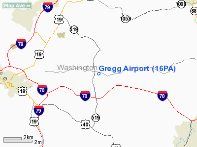
Location & QuickFacts
| FAA Information Effective: | 2008-09-25 |
| Airport Identifier: | 16PA |
| Airport Status: | Closed Indefinitely |
| Longitude/Latitude: | 080-07-39.2010W/40-10-50.2560N
-80.127556/40.180627 (Estimated) |
| Elevation: | 1200 ft / 365.76 m (Estimated) |
| Land: | 30 acres |
| From nearest city: | 0 nautical miles E of Eighty Four, PA |
| Location: | Washington County, PA |
| Magnetic Variation: | 07W (1985) |
Owner & Manager
| Ownership: | Privately owned |
| Owner: | Franklin S. Gregg |
| Address: | Rd 1, Box 154
Cannonsburg, PA 15317 |
| Phone number: | 412-222-9446 |
| Manager: | Franklin S. Gregg |
| Address: | Rd 1, Box 154
Cannonsburg, PA 15317 |
| Phone number: | 412-745-8987 |
Airport Operations and Facilities
| Airport Use: | Private |
| Wind indicator: | Yes |
| Segmented Circle: | No |
| Control Tower: | No |
| Landing fee charge: | No |
| Sectional chart: | Detroit |
| Region: | AEA - Eastern |
| Boundary ARTCC: | ZOB - Cleveland |
| Tie-in FSS: | AOO - Altoona |
| FSS on Airport: | No |
| FSS Toll Free: | 1-800-WX-BRIEF |
Airport Services
| Airframe Repair: | NONE |
| Power Plant Repair: | NONE |
Runway Information
Runway 09/27
| Dimension: | 2500 x 100 ft / 762.0 x 30.5 m |
| Surface: | TURF, |
| |
Runway 09 |
Runway 27 |
| Traffic Pattern: | Left | Left |
|
Radio Navigation Aids
| ID |
Type |
Name |
Ch |
Freq |
Var |
Dist |
| PNU | NDB | Washington County | | 255.00 | 08W | 2.7 nm |
| MKP | NDB | Mc Keesport | | 287.00 | 07W | 19.0 nm |
| VV | NDB | Camor | | 299.00 | 08W | 25.1 nm |
| CFX | NDB | Cadiz | | 239.00 | 07W | 40.8 nm |
| BHU | NDB | Benje | | 382.00 | 07W | 41.0 nm |
| TSO | NDB | Tolson | | 395.00 | 07W | 49.2 nm |
| AGC | VOR/DME | Allegheny | 037X | 110.00 | 09W | 7.1 nm |
| HLG | VOR/DME | Wheeling | 059X | 112.20 | 07W | 20.8 nm |
| AIR | VOR/DME | Bellaire | 118X | 117.10 | 07W | 33.2 nm |
| MMJ | VORTAC | Montour | 057X | 112.00 | 08W | 18.7 nm |
| IHD | VORTAC | Indian Head | 019X | 108.20 | 06W | 37.5 nm |
| EWC | VORTAC | Ellwood City | 105X | 115.80 | 08W | 38.9 nm |
| MGW | VORTAC | Morgantown | 053X | 111.60 | 05W | 39.5 nm |
Remarks
- TREES NORTH SIDE.
- (ARPT STATUS) ARPT CLSD INDEFLY.
- VFR ONLY PROVIDED RGT TFC INDICATOR INSTLD NEAR RWY 27 END...RWY 9 THR DSPLCD TO MAINTAIN APCH CLEARANCE PER PART 77.
Images and information placed above are from
http://www.airport-data.com/airport/16PA/
We thank them for the data!
| General Info
|
| Country |
United States
|
| State |
PENNSYLVANIA
|
| FAA ID |
16PA
|
| Latitude |
40-10-50.256N
|
| Longitude |
080-07-39.201W
|
| Elevation |
1200 feet
|
| Near City |
EIGHTY FOUR
|
We don't guarantee the information is fresh and accurate. The data may
be wrong or outdated.
For more up-to-date information please refer to other sources.
|
|


