 |
|
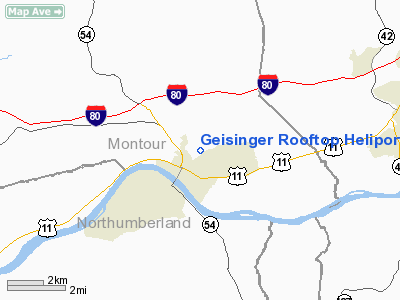
Geisinger Rooftop Heliport |
Location & QuickFacts
| FAA Information Effective: | 2008-09-25 |
| Airport Identifier: | 79PN |
| Airport Status: | Operational |
| Longitude/Latitude: | 076-36-14.8350W/40-58-22.3120N
-76.604121/40.972864 (Estimated) |
| Elevation: | 661 ft / 201.47 m (Surveyed) |
| Land: | 0 acres |
| From nearest city: | 0 nautical miles SW of Danville, PA |
| Location: | Montour County, PA |
| Magnetic Variation: | 11W (1985) |
Owner & Manager
| Ownership: | Privately owned |
| Owner: | Geisinger Medical Center |
| Address: |
Danville, PA 17822 |
| Phone number: | 717-271-6666 |
| Manager: | Paul Davis |
| Address: | Geisinger Medical Center
Danville, PA 17822-2005 |
| Phone number: | 717-271-6217 |
Airport Operations and Facilities
| Airport Use: | Private |
| Wind indicator: | Yes |
| Segmented Circle: | No |
| Control Tower: | No |
| Landing fee charge: | No |
| Sectional chart: | New York |
| Region: | AEA - Eastern |
| Boundary ARTCC: | ZNY - New York |
| Tie-in FSS: | IPT - Williamsport |
| FSS on Airport: | No |
| FSS Toll Free: | 1-800-WX-BRIEF |
Airport Communications
Runway Information
Helipad H1
| Dimension: | 55 x 55 ft / 16.8 x 16.8 m |
| Surface: | CONC,
ROOFTOP FACILITY. |
| |
Runway H1 |
Runway |
| Traffic Pattern: | Left | Left |
|
Radio Navigation Aids
| ID |
Type |
Name |
Ch |
Freq |
Var |
Dist |
| PIX | NDB | Picture Rocks | | 344.00 | 09W | 18.9 nm |
| HXM | NDB | Humbolt | | 366.00 | 10W | 27.6 nm |
| BZJ | NDB | Bellgrove | | 328.00 | 10W | 32.4 nm |
| CYE | NDB | Crystal Lake | | 410.00 | 11W | 37.8 nm |
| LQX | NDB | Carbon | | 339.00 | 12W | 39.6 nm |
| HZL | VOR | Hazleton | | 109.40 | 09W | 21.7 nm |
| FQM | VOR/DME | Williamsport | 091X | 114.40 | 09W | 23.3 nm |
| ETX | VOR/DME | East Texas | 039X | 110.20 | 09W | 48.1 nm |
| MIP | VORTAC | Milton | 029X | 109.20 | 09W | 4.1 nm |
| SEG | VORTAC | Selinsgrove | 041X | 110.40 | 08W | 16.8 nm |
| RAV | VORTAC | Ravine | 093X | 114.60 | 11W | 25.2 nm |
| LVZ | VORTAC | Wilkes-barre | 053X | 111.60 | 10W | 45.2 nm |
| HAR | VORTAC | Harrisburg | 072X | 112.50 | 10W | 45.6 nm |
| MDT | VOT | Harrisburg International | | 110.00 | | 47.2 nm |
Images and information placed above are from
http://www.airport-data.com/airport/79PN/
We thank them for the data!
| General Info
|
| Country |
United States
|
| State |
PENNSYLVANIA
|
| FAA ID |
79PN
|
| Latitude |
40-58-22.312N
|
| Longitude |
076-36-14.835W
|
| Elevation |
661 feet
|
| Near City |
DANVILLE
|
We don't guarantee the information is fresh and accurate. The data may
be wrong or outdated.
For more up-to-date information please refer to other sources.
|
|


