 |
|
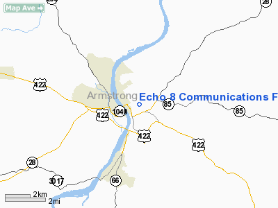
Echo 8 Communications Facility Heliport |
Location & QuickFacts
| FAA Information Effective: | 2008-09-25 |
| Airport Identifier: | 8PA5 |
| Airport Status: | Operational |
| Longitude/Latitude: | 079-30-22.1600W/40-48-52.2300N
-79.506156/40.814508 (Estimated) |
| Elevation: | 1304 ft / 397.46 m (Estimated) |
| Land: | 0 acres |
| From nearest city: | 0 nautical miles N of Kittanning, PA |
| Location: | Armstrong County, PA |
| Magnetic Variation: | 09W (1990) |
Owner & Manager
| Ownership: | Privately owned |
| Owner: | Crown Communications |
| Address: | Penn Center West Iii, Bldg 3
Pittsburgh, PA 15276
SUITE 229. |
| Phone number: | 412-788-0906 |
| Manager: | Robert Crown |
| Address: | Penn Center West Iii, Bldg 3
Pittsburgh, PA 15276
SUITE 229. |
| Phone number: | 412-788-0906 |
Airport Operations and Facilities
| Airport Use: | Private |
| Segmented Circle: | No |
| Control Tower: | No |
| Sectional chart: | Detroit |
| Region: | AEA - Eastern |
| Boundary ARTCC: | ZOB - Cleveland |
| Tie-in FSS: | AOO - Altoona |
| FSS on Airport: | No |
| FSS Toll Free: | 1-800-WX-BRIEF |
Runway Information
Helipad H1
| Dimension: | 34 x 34 ft / 10.4 x 10.4 m |
| Surface: | CONC, |
| |
Runway H1 |
Runway |
| Traffic Pattern: | Left | Left |
|
Radio Navigation Aids
| ID |
Type |
Name |
Ch |
Freq |
Var |
Dist |
| INP | NDB | Indiana | | 242.00 | 08W | 22.9 nm |
| BHU | NDB | Benje | | 382.00 | 07W | 28.5 nm |
| MKP | NDB | Mc Keesport | | 287.00 | 07W | 30.3 nm |
| UCP | NDB | Castle | | 272.00 | 09W | 43.2 nm |
| FKL | VOR | Franklin | | 109.60 | 06W | 40.7 nm |
| CIP | VOR/DME | Clarion | 076X | 112.90 | 06W | 20.1 nm |
| REC | VOR/DME | Revloc | 043X | 110.60 | 09W | 38.2 nm |
| AGC | VOR/DME | Allegheny | 037X | 110.00 | 09W | 40.4 nm |
| EWC | VORTAC | Ellwood City | 105X | 115.80 | 08W | 32.1 nm |
| MMJ | VORTAC | Montour | 057X | 112.00 | 08W | 37.0 nm |
| JST | VORTAC | Johnstown | 077X | 113.00 | 06W | 42.9 nm |
Remarks
- PRVDD USED FOR VFR OPERATIONS ONLY; CAUTION EXERCISED VICINITY OF TOWER LCTD WEST.
Images and information placed above are from
http://www.airport-data.com/airport/8PA5/
We thank them for the data!
| General Info
|
| Country |
United States
|
| State |
PENNSYLVANIA
|
| FAA ID |
8PA5
|
| Latitude |
40-48-52.230N
|
| Longitude |
079-30-22.160W
|
| Elevation |
1304 feet
|
| Near City |
KITTANNING
|
We don't guarantee the information is fresh and accurate. The data may
be wrong or outdated.
For more up-to-date information please refer to other sources.
|
|


