|
|
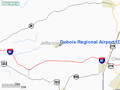
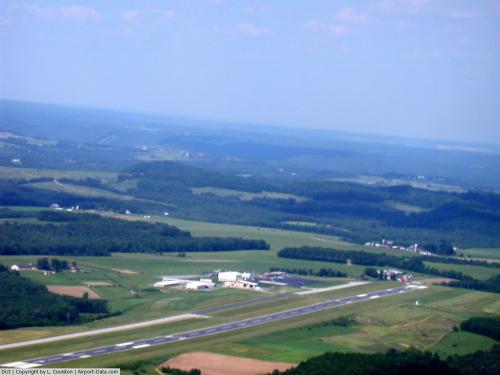
| DuBois Regional Airport |
 |
| IATA: DUJ – ICAO: KDUJ – FAA LID: DUJ |
| Summary |
| Airport type |
Public |
| Owner |
Clearfield-Jefferson Counties Regional Airport Authority |
| Location |
Washington Township, Jefferson County, Pennsylvania |
| Elevation AMSL |
1,817 ft / 554 m |
| Coordinates |
41°10′41″N 78°53′55″W / 41.17806°N 78.89861°W / 41.17806; -78.89861 |
| Runways |
| Direction |
Length |
Surface |
| ft |
m |
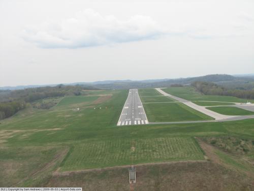
| 7/25 |
5,504 |
1,678 |
Asphalt/Treated |
DuBois Regional Airport (IATA: DUJ, ICAO: KDUJ, FAA LID: DUJ), formerly known as DuBois-Jefferson County Airport, is a public airport located on Pennsylvania State Route 830 in Washington Township, Jefferson County, Pennsylvania, USA. Owned and operated by the Clearfield-Jefferson Counties Regional Airport Authority, which is based on the airport grounds, the airport covers 399 acres (161 ha) and has one runway. It is mostly used for general aviation but is also served by one commercial airline, Gulfstream International Airlines, which has a maintenance base at the airport. Service is subsidized by the Essential Air Service program. The airport serves Clearfield, Elk, and Jefferson counties.
DuBois Regional Airport is a popular refueling stop for many transient aircraft due to its proximity to Interstate 80 and several main east-west air routes, as well as an on-field restaurant. History
In the early 1950s, the City of DuBois created a Municipal Airport Authority which looked into means of expanding the existing DuBois City Airport, in the Oklahoma section, east of the city. They determined that site was unsuitable for further expansion, and joined with Jefferson County officials to procure the present site, 6 statute miles (10 km) northwest of DuBois. Construction was completed and the first flight was made on June 1, 1960 by Allegheny Airlines. Throughout the 1960s and 1970s, radio navigational aids were added, including a non-directional beacon (DU), and finally a full Instrument Landing System (ILS) for runway 25 (IDUJ).
Brockway Glass Corporation, headquartered in nearby Brockway, Pennsylvania, constructed a corporate hangar on the apron to house their corporate aircraft (and later a commuter airline service), and Fixed Base Operator Beechwoods Flying Service constructed general aviation "T hangars", fuel pumps and maintenance hangars. The FAA opened a Flight Service Station in 1963 to provide weather observation and aviation advisory services to pilots in the region, which is noted for rapidly changing and severe weather. In the 1970s, the FAA also located a regional radio navigational maintenance facility on the field.
In 1988, Brockway Glass was taken over by Owens-Illinois, and its assets were liquidated, including the Crown Airways commuter airline. The Flight Service Station was closed in 1990 during FSS consolidation, and its functions were assumed by the Altoona FSS.
Since 1991, the airport complex has continued to expand and renovate its facilities, grounds, and infrastructure. Since 2001 it has been designated a Foreign Trade Zone. State route PA-830 has been relocated to a new access road, and dedicated as the "Bud Scherer Memorial Highway" to honor the memory of longtime Airport Manager Francis "Bud" Scherer. It carries traffic from U.S. Interstate 80 and the borough of Falls Creek.
Airline and destinations
| Airlines |
Destinations |
| Continental Connection operated by Gulfstream International Airlines |
Cleveland, Franklin |
Incidents and accidents
- On 27 March 1975, Douglas C-48A N6 of the Federal Aviation Administration crashed on take-off. The aircraft was operating an executive flight to Harrisburg International Airport. All eleven people on board survived.
- On 9 April 2003 - Skyway Enterprises Shorts 330-200 aircraft (N805SW), on a flight from Pittsburgh was about to land at DuBois Regional Airport, when an engine surged, the pilot attempted to go round again to land and crashed left of the runway. The aircraft was substantially damaged but the two crew survived.
The above content comes from Wikipedia and is published under free licenses – click here to read more.
 |
(Click on the photo to enlarge) |
 |
(Click on the photo to enlarge) |
 |
(Click on the photo to enlarge) |
Location & QuickFacts
| FAA Information Effective: | 2008-09-25 |
| Airport Identifier: | DUJ |
| Airport Status: | Operational |
| Longitude/Latitude: | 078-53-55.3120W/41-10-41.7580N
-78.898698/41.178266 (Estimated) |
| Elevation: | 1817 ft / 553.82 m (Surveyed) |
| Land: | 399 acres |
| From nearest city: | 7 nautical miles NW of Dubois, PA |
| Location: | Jefferson County, PA |
| Magnetic Variation: | 08W (1980) |
Owner & Manager
| Ownership: | Publicly owned |
| Owner: | Clearfield-jefferson Counties
REGIONAL AIRPORT AUTHORITY |
| Address: | 377 Aviation Way
Reynoldsville, PA 15851 |
| Phone number: | 814-328-5311 |
| Manager: | Robert W. Shaffer |
| Address: | Po Box 299
Falls Creek, PA 15840 |
| Phone number: | 814-328-5311 |
Airport Operations and Facilities
| Airport Use: | Open to public |
| Wind indicator: | Yes |
| Segmented Circle: | No |
| Control Tower: | No |
| Lighting Schedule: | DUSK-DAWN
ACTVT HIRL RY 07/25, REIL & VASI RY 07, MALSR RY 25, & TWY LGTS - CTAF. PAPI RY 25 ON 24 HRS. |
| Beacon Color: | Clear-Green (lighted land airport) |
| Sectional chart: | Detroit |
| Region: | AEA - Eastern |
| Traffic Pattern Alt: | 983 ft |
| Boundary ARTCC: | ZOB - Cleveland |
| Tie-in FSS: | AOO - Altoona |
| FSS on Airport: | No |
| FSS Toll Free: | 1-800-WX-BRIEF |
| NOTAMs Facility: | DUJ (NOTAM-d service avaliable) |
| Certification type/date: | II A S 04/199
PPR 24 HRS FOR ACR OPNS WITH MORE THAN 30 PSGR SEATS; CALL AMGR 814-328-5311. |
| Federal Agreements: | NGYH |
Airport Communications
| CTAF: | 123.000 |
| Unicom: | 123.000 |
Airport Services
| Fuel available: | 100LLA |
| Airframe Repair: | MAJOR |
| Power Plant Repair: | MAJOR |
| Bottled Oxygen: | LOW |
| Bulk Oxygen: | NONE |
Runway Information
Runway 07/25
| Dimension: | 5504 x 100 ft / 1677.6 x 30.5 m |
| Surface: | ASPH-TRTD, Good Condition |
| Surface Treatment: | Saw-cut or plastic Grooved |
| Weight Limit: | Single wheel: 45000 lbs.
Dual wheel: 60000 lbs.
Dual tandem wheel: 93000 lbs. |
| Edge Lights: | High |
| |
Runway 07 |
Runway 25 |
| Longitude: | 078-54-27.2030W | 078-53-23.4180W |
| Latitude: | 41-10-29.1690N | 41-10-54.3460N |
| Elevation: | 1816.00 ft | 1816.00 ft |
| Alignment: | 62 | 127 |
| ILS Type: | | ILS
|
| Traffic Pattern: | Left | Left |
| Markings: | Precision instrument, Good Condition | Precision instrument, Good Condition |
| Crossing Height: | 30.00 ft | 57.00 ft |
| VASI: | 4-box on left side | 4-light PAPI on left side |
| Visual Glide Angle: | 3.00° | 3.00° |
| Approach lights: | | MALSR |
| Runway End Identifier: | Yes | |
|
Radio Navigation Aids
| ID |
Type |
Name |
Ch |
Freq |
Var |
Dist |
| INP | NDB | Indiana | | 242.00 | 08W | 33.7 nm |
| FKL | VOR | Franklin | | 109.60 | 06W | 46.0 nm |
| CIP | VOR/DME | Clarion | 076X | 112.90 | 06W | 25.4 nm |
| REC | VOR/DME | Revloc | 043X | 110.60 | 09W | 38.6 nm |
| BFD | VOR/DME | Bradford | 113X | 116.60 | 07W | 38.7 nm |
| ETG | VORTAC | Keating | 107X | 116.00 | 10W | 34.3 nm |
| TON | VORTAC | Tyrone | 096X | 114.90 | 07W | 37.1 nm |
| TDT | VORTAC | Tidioute | 123X | 117.60 | 09W | 39.7 nm |
| PSB | VORTAC | Philipsburg | 102X | 115.50 | 10W | 44.0 nm |
| SLT | VORTAC | Slate Run | 086X | 113.90 | 08W | 46.5 nm |
Remarks
- FLOCKS OF BIRDS ON & INVOF ARPT.
- TPA 983 FT AGL. TPA FOR LARGE TURBINE POWERED ACFT 1483 FT AGL.
Images and information placed above are from
http://www.airport-data.com/airport/DUJ/
We thank them for the data!
| General Info
|
| Country |
United States
|
| State |
PENNSYLVANIA
|
| FAA ID |
DUJ
|
| Latitude |
41-10-41.758N
|
| Longitude |
078-53-55.312W
|
| Elevation |
1817 feet
|
| Near City |
DU BOIS
|
We don't guarantee the information is fresh and accurate. The data may
be wrong or outdated.
For more up-to-date information please refer to other sources.
|
|