 |
|
| Doylestown Airport |
| IATA: DYL – ICAO: KDYL – FAA LID: DYL |
| Summary |
| Airport type |
Public |
| Owner |
Bucks County Airport Authority (BCAA) |
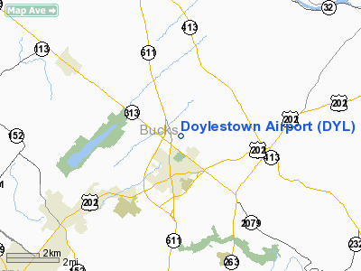
| Serves |
Doylestown, Pennsylvania |
| Elevation AMSL |
394 ft / 120 m |
| Coordinates |
40°19′59″N 075°07′20″W / 40.33306°N 75.12222°W / 40.33306; -75.12222 |
| Website |
www.bcaanet.org |
| Runways |
| Direction |
Length |
Surface |
| ft |
m |
| 5/23 |
3,004 |
916 |
Asphalt |
| Statistics (2008) |
| Aircraft operations |
42,000 |
| Based aircraft |
174 |
| Source: Federal Aviation Administration |
Doylestown Airport (IATA: DYL, ICAO: KDYL, FAA LID: DYL) is a public use airport located in Bucks County, Pennsylvania, United States and owned by the Bucks County Airport Authority. It is two nautical miles (3.7 km) north of the central business district of Doylestown, Pennsylvania. The airport is home to a single fixed base operator, Leading Edge Aviation, as well as a Civil Air Patrol squadron, flight training, and aircraft rentals. History
The Doylestown Airport was dedicated on December 24, 1964. Between the years of 1957 and 1960, the airport was owned and managed by John Van Sant, a popular aviator in Pennsylvania and founder of the Van Sant Airport. The airport is currently run by the Bucks County Airport Authority (BCAA).
Facilities and aircraft
Doylestown Airport covers an area of 200 acres (81 ha) at an elevation of 394 feet (120 m) above mean sea level. It has one runway designated 5/23 with an asphalt surface measuring 3,004 by 60 feet (916 x 18 m).
For the 12-month period ending August 21, 2008, the airport had 42,000 aircraft operations, an average of 115 per day: 93% general aviation, 7% air taxi and <1% military. At that time there were 174 aircraft based at this airport: 92% single-engine, 7% multi-engine and 1% helicopter.
Expansion
Proposals to extend the single runway at Doylestown Airport are currently being debated. The BCAA wants to extend the runway by 800 feet to prepare for the expected increase in safety of airport activity. Along with the runway extension, more hangars are recommended to accommodate the increase in traffic. Many residents nearby are against such expansions, as they fear it will encourage more jets and unwanted noise. If approved, the 800 foot extension, 94+ aircraft hangar spaces, and other improvements will total a cost of $26.9 million.
The above content comes from Wikipedia and is published under free licenses – click here to read more.
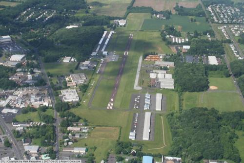 |
(Click on the photo to enlarge) |
Location & QuickFacts
| FAA Information Effective: | 2008-09-25 |
| Airport Identifier: | DYL |
| Airport Status: | Operational |
| Longitude/Latitude: | 075-07-20.4180W/40-19-58.9810N
-75.122338/40.333050 (Estimated) |
| Elevation: | 394 ft / 120.09 m (Surveyed) |
| Land: | 200 acres |
| From nearest city: | 2 nautical miles N of Doylestown, PA |
| Location: | Bucks County, PA |
| Magnetic Variation: | 12W (1995) |
Owner & Manager
| Ownership: | Publicly owned |
| Owner: | Bucks County Airport Auth |
| Address: | 3879 Old Easton Rd Box 1185
Doylestown, PA 18902 |
| Phone number: | 215-345-1970 |
| Manager: | Richard Witt |
| Address: | 3879 Old Easton Rd Box 1185
Doylestown, PA 18902 |
| Phone number: | 215-345-1970 |
Airport Operations and Facilities
| Airport Use: | Open to public |
| Wind indicator: | Yes |
| Segmented Circle: | Yes |
| Control Tower: | No |
| Lighting Schedule: | DUSK-DAWN
ACTVT REIL RY 23 - CTAF. |
| Beacon Color: | Clear-Green (lighted land airport) |
| Landing fee charge: | No |
| Sectional chart: | New York |
| Region: | AEA - Eastern |
| Traffic Pattern Alt: | 1000 ft |
| Boundary ARTCC: | ZNY - New York |
| Tie-in FSS: | IPT - Williamsport |
| FSS on Airport: | No |
| FSS Toll Free: | 1-800-WX-BRIEF |
| NOTAMs Facility: | DYL (NOTAM-d service avaliable) |
| Federal Agreements: | NGY |
Airport Communications
| CTAF: | 122.975 |
| Unicom: | 122.975 |
Airport Services
| Fuel available: | 100LLA |
| Airframe Repair: | MAJOR |
| Power Plant Repair: | MAJOR |
| Bottled Oxygen: | LOW |
| Bulk Oxygen: | NONE |
Runway Information
Runway 05/23
| Dimension: | 3004 x 60 ft / 915.6 x 18.3 m |
| Surface: | ASPH, Good Condition |
| Weight Limit: | Single wheel: 12000 lbs. |
| Edge Lights: | Medium |
| |
Runway 05 |
Runway 23 |
| Longitude: | 075-07-32.1830W | 075-07-08.6180W |
| Latitude: | 40-19-47.2410N | 40-20-10.8140N |
| Elevation: | 391.00 ft | 393.00 ft |
| Alignment: | 37 | 127 |
| Traffic Pattern: | Left | Left |
| Markings: | Non-precision instrument, Good Condition | Non-precision instrument, Good Condition |
| Crossing Height: | 0.00 ft | 20.00 ft |
| VASI: | 2-box SAVASI on left side | 2-light PAPI on left side |
| Visual Glide Angle: | 5.00° | 3.00° |
| Runway End Identifier: | | Yes |
| Obstruction: | 27 ft tree, 272.0 ft from runway, 207 ft left of centerline, 2:1 slope to clear | 12 ft tree, 223.0 ft from runway, 162 ft left of centerline, 1:1 slope to clear
RY 23 HAS +6 FT SHRUBS, 174 FT FM RY, 38 FT L. |
|
Radio Navigation Aids
| ID |
Type |
Name |
Ch |
Freq |
Var |
Dist |
| EWR | FAN MARKER | Maryann | | | 11W | 48.2 nm |
| DYL | NDB | Doylestown | | 237.00 | 10W | 0.2 nm |
| NXX | NDB | Willow Grove | | 388.00 | 12W | 8.7 nm |
| UKT | NDB | Quakertown | | 208.00 | 12W | 9.7 nm |
| ING | NDB | Ambler | | 275.00 | 11W | 14.5 nm |
| CAT | NDB | Chatham | | 254.00 | 11W | 40.0 nm |
| NEL | NDB | Lakehurst | | 396.00 | 13W | 40.1 nm |
| LQX | NDB | Carbon | | 339.00 | 12W | 40.9 nm |
| NXX | TACAN | Willow Grove | 061X | | 10W | 8.4 nm |
| NEL | TACAN | Lakehurst | 055X | | 11W | 39.6 nm |
| NEL | UHF/NDB | Lakehurst | | 274.80 | 13W | 40.1 nm |
| PNE | VOR | North Philadelphia | | 112.00 | 10W | 15.9 nm |
| CKZ | VOR/DME | Pennridge | 025Y | 108.85 | 12W | 8.4 nm |
| ARD | VOR/DME | Yardley | 019X | 108.20 | 10W | 10.9 nm |
| SBJ | VOR/DME | Solberg | 076X | 112.90 | 10W | 23.0 nm |
| ETX | VOR/DME | East Texas | 039X | 110.20 | 09W | 29.7 nm |
| BWZ | VOR/DME | Broadway | 089X | 114.20 | 11W | 31.2 nm |
| STW | VOR/DME | Stillwater | 033X | 109.60 | 11W | 41.5 nm |
| COL | VOR/DME | Colts Neck | 101X | 115.40 | 11W | 44.1 nm |
| PTW | VORTAC | Pottstown | 112X | 116.50 | 09W | 21.2 nm |
| FJC | VORTAC | Allentown | 122X | 117.50 | 10W | 28.1 nm |
| RBV | VORTAC | Robbinsville | 085X | 113.80 | 10W | 29.8 nm |
| GXU | VORTAC | Mc Guire | 043X | 110.60 | 11W | 31.0 nm |
| MXE | VORTAC | Modena | 079X | 113.20 | 09W | 35.5 nm |
| OOD | VORTAC | Woodstown | 075X | 112.80 | 10W | 42.7 nm |
| CYN | VORTAC | Coyle | 081X | 113.40 | 10W | 44.4 nm |
| DQO | VORTAC | Dupont | 087X | 114.00 | 10W | 45.3 nm |
| VCN | VORTAC | Cedar Lake | 099X | 115.20 | 10W | 48.3 nm |
| PHL | VOT | Philadelphia Intl | | 109.80 | | 28.4 nm |
Remarks
- NOISE ABATEMENT PROCEDURES IN EFFECT; CTC AMGR 215-340-0707.
- TOUCH AND GO LNDGS PROHIBITED.
- MIDFIELD TWY CLSD INDEFLY.
- EXISTED PRIOR TO 05/15/59.
Images and information placed above are from
http://www.airport-data.com/airport/DYL/
We thank them for the data!
| General Info
|
| Country |
United States
|
| State |
PENNSYLVANIA
|
| FAA ID |
DYL
|
| Latitude |
40-19-58.981N
|
| Longitude |
075-07-20.418W
|
| Elevation |
394 feet
|
| Near City |
DOYLESTOWN
|
We don't guarantee the information is fresh and accurate. The data may
be wrong or outdated.
For more up-to-date information please refer to other sources.
|
|


