 |
|
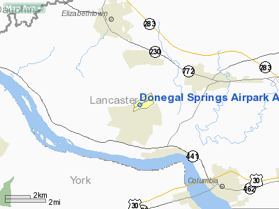
Donegal Springs Airpark Airport |
Location & QuickFacts
| FAA Information Effective: | 2008-09-25 |
| Airport Identifier: | N71 |
| Airport Status: | Operational |
| Longitude/Latitude: | 076-34-27.6790W/40-05-31.9440N
-76.574355/40.092207 (Estimated) |
| Elevation: | 458 ft / 139.60 m (Estimated) |
| Land: | 29 acres |
| From nearest city: | 3 nautical miles SW of Mount Joy/marietta, PA |
| Location: | Lancaster County, PA |
| Magnetic Variation: | 09W (1975) |
Owner & Manager
| Ownership: | Privately owned |
| Owner: | Donegal Springs Airpark, Inc. |
| Address: | 186 Arpt Rd
Marietta, PA 17547 |
| Phone number: | 717-653-8181 |
| Manager: | Jay Stout |
| Address: | 186 Arpt Rd
Marietta, PA 17547 |
| Phone number: | 717-653-8181 |
Airport Operations and Facilities
| Airport Use: | Open to public |
| Wind indicator: | No |
| Segmented Circle: | No |
| Control Tower: | No |
| Lighting Schedule: | DUSK-0000
ACTVT MIRL RY 10/28 & ROTG BCN BTN 0000-SR - CTAF. |
| Beacon Color: | Clear-Green (lighted land airport) |
| Landing fee charge: | No |
| Sectional chart: | New York |
| Region: | AEA - Eastern |
| Traffic Pattern Alt: | 800 ft |
| Boundary ARTCC: | ZNY - New York |
| Tie-in FSS: | IPT - Williamsport |
| FSS on Airport: | No |
| FSS Toll Free: | 1-800-WX-BRIEF |
| NOTAMs Facility: | IPT (NOTAM-d service avaliable) |
Airport Communications
| CTAF: | 122.800 |
| Unicom: | 122.800 |
Airport Services
| Fuel available: | 100LL |
| Airframe Repair: | MAJOR |
| Power Plant Repair: | MAJOR |
| Bottled Oxygen: | HIGH |
| Bulk Oxygen: | LOW |
Runway Information
Runway 10/28
| Dimension: | 3250 x 50 ft / 990.6 x 15.2 m |
| Surface: | ASPH, Fair Condition |
| Weight Limit: | Single wheel: 12500 lbs. |
| Edge Lights: | Medium |
| |
Runway 10 |
Runway 28 |
| Longitude: | 076-34-48.5510W | 076-34-06.9050W |
| Latitude: | 40-05-30.4920N | 40-05-33.4320N |
| Elevation: | 458.00 ft | 400.00 ft |
| Alignment: | 85 | 127 |
| Traffic Pattern: | Left | Left |
| Markings: | Basic, Poor Condition
MARKINGS FADED & CHIPPED | Non-precision instrument, Poor Condition
MARKINGS FADED & CHIPPED. |
| Displaced threshold: | 390.00 ft
RW 10 DSPLCD THLD BAR 300' FROM RW END, DSPLCD THLD LGTS 390' FROM RW END. | 0.00 ft |
| Obstruction: | 47 ft tree, 689.0 ft from runway, 162 ft left of centerline, 10:1 slope to clear
+35 FT HOUSE 83 FT FM THLD 23` FT RIGHT APCH RATIO 8:1 BASED ON DSPLCD THLD.
RY 10 HAS +15 FT ROAD 16 FT FM RY END; +40 FT TREES 140-240 FT R OF RY CNTRLN. | 64 ft trees, 1618.0 ft from runway, 258 ft right of centerline, 22:1 slope to clear
RY 28 HAS +4 BRUSH 6 FT FM RY END; L AND R OF RY CNTRLN. |
|
Radio Navigation Aids
| ID |
Type |
Name |
Ch |
Freq |
Var |
Dist |
| EUD | NDB | York | | 254.00 | 11W | 17.4 nm |
| BZJ | NDB | Bellgrove | | 328.00 | 10W | 20.7 nm |
| APG | NDB | Aberdeen | | 349.00 | 11W | 39.9 nm |
| IUB | NDB | Institute | | 404.00 | 08W | 48.5 nm |
| MTN | NDB | Martin | | 342.00 | 11W | 48.5 nm |
| FND | NDB | Ellicott | | 371.00 | 11W | 49.3 nm |
| MTN | TACAN | Martin | 068X | | 11W | 46.4 nm |
| PPM | VOR/DME | Phillips | 021X | 108.40 | 09W | 42.0 nm |
| LRP | VORTAC | Lancaster | 120X | 117.30 | 09W | 13.1 nm |
| HAR | VORTAC | Harrisburg | 072X | 112.50 | 10W | 26.0 nm |
| RAV | VORTAC | Ravine | 093X | 114.60 | 11W | 27.7 nm |
| EMI | VORTAC | Westminster | 126X | 117.90 | 08W | 40.5 nm |
| MXE | VORTAC | Modena | 079X | 113.20 | 09W | 42.9 nm |
| SEG | VORTAC | Selinsgrove | 041X | 110.40 | 08W | 44.3 nm |
| PTW | VORTAC | Pottstown | 112X | 116.50 | 09W | 47.2 nm |
| MDT | VOT | Harrisburg International | | 110.00 | | 10.7 nm |
Images and information placed above are from
http://www.airport-data.com/airport/N71/
We thank them for the data!
| General Info
|
| Country |
United States
|
| State |
PENNSYLVANIA
|
| FAA ID |
N71
|
| Latitude |
40-05-31.944N
|
| Longitude |
076-34-27.679W
|
| Elevation |
458 feet
|
| Near City |
MOUNT JOY/MARIETTA
|
We don't guarantee the information is fresh and accurate. The data may
be wrong or outdated.
For more up-to-date information please refer to other sources.
|
|


