 |
|
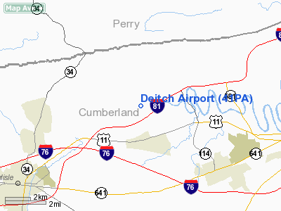
Location & QuickFacts
| FAA Information Effective: | 2008-09-25 |
| Airport Identifier: | 41PA |
| Airport Status: | Operational |
| Longitude/Latitude: | 077-04-52.9220W/40-15-28.3160N
-77.081367/40.257866 (Estimated) |
| Elevation: | 420 ft / 128.02 m (Estimated) |
| Land: | 0 acres |
| From nearest city: | 2 nautical miles S of New Kingstown, PA |
| Location: | Cumberland County, PA |
| Magnetic Variation: | 10W (1990) |
Owner & Manager
| Ownership: | Privately owned |
| Owner: | Guy W Deitch, Sr |
| Address: | 275 Rich Valley Rd
Carlisle, PA 17013 |
| Phone number: | 717-766-3408 |
| Manager: | Guy W Deitch, Sr |
| Address: | 275 Rich Valley Rd
Carlisle, PA 17013 |
| Phone number: | 717-766-3408 |
Airport Operations and Facilities
| Airport Use: | Private |
| Segmented Circle: | No |
| Control Tower: | No |
| Sectional chart: | New York |
| Region: | AEA - Eastern |
| Boundary ARTCC: | ZNY - New York |
| Tie-in FSS: | IPT - Williamsport |
| FSS on Airport: | No |
| FSS Toll Free: | 1-800-WX-BRIEF |
Runway Information
Runway 08/26
| Dimension: | 1200 x 100 ft / 365.8 x 30.5 m |
| Surface: | TURF, |
| |
Runway 08 |
Runway 26 |
| Traffic Pattern: | Left | Left |
| Obstruction: | | 40 ft tree, 50.0 ft from runway |
|
Runway 16/34
| Dimension: | 1276 x 100 ft / 388.9 x 30.5 m |
| Surface: | TURF, |
| |
Runway 16 |
Runway 34 |
| Traffic Pattern: | Left | Left |
|
Radio Navigation Aids
| ID |
Type |
Name |
Ch |
Freq |
Var |
Dist |
| EUD | NDB | York | | 254.00 | 11W | 22.4 nm |
| BZJ | NDB | Bellgrove | | 328.00 | 10W | 26.5 nm |
| RV | NDB | Stroh | | 407.00 | 10W | 36.2 nm |
| HGR | VOR | Hagerstown | | 109.80 | 07W | 49.0 nm |
| HAR | VORTAC | Harrisburg | 072X | 112.50 | 10W | 2.7 nm |
| RAV | VORTAC | Ravine | 093X | 114.60 | 11W | 28.3 nm |
| SEG | VORTAC | Selinsgrove | 041X | 110.40 | 08W | 33.3 nm |
| LRP | VORTAC | Lancaster | 120X | 117.30 | 09W | 37.2 nm |
| THS | VORTAC | St Thomas | 097X | 115.00 | 07W | 44.5 nm |
| EMI | VORTAC | Westminster | 126X | 117.90 | 08W | 46.1 nm |
| MIP | VORTAC | Milton | 029X | 109.20 | 09W | 49.8 nm |
| MDT | VOT | Harrisburg International | | 110.00 | | 15.0 nm |
Remarks
- PRVDD VFR ONLY; AND AS NOTED IN SECTION E OF FAA FORM 7480-1 SUBMITTED, RY 08 WILL NOT BE USE FOR TAKEOFFS & RY 26 WILL NOT BE USED FOR LANDINGS.
Images and information placed above are from
http://www.airport-data.com/airport/41PA/
We thank them for the data!
| General Info
|
| Country |
United States
|
| State |
PENNSYLVANIA
|
| FAA ID |
41PA
|
| Latitude |
40-15-28.316N
|
| Longitude |
077-04-52.922W
|
| Elevation |
420 feet
|
| Near City |
NEW KINGSTOWN
|
We don't guarantee the information is fresh and accurate. The data may
be wrong or outdated.
For more up-to-date information please refer to other sources.
|
|


