 |
|
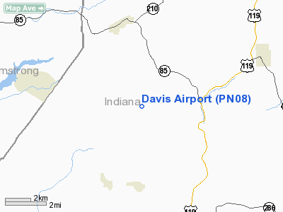
Location & QuickFacts
| FAA Information Effective: | 2008-09-25 |
| Airport Identifier: | PN08 |
| Airport Status: | Operational |
| Longitude/Latitude: | 079-09-35.6300W/40-44-04.6300N
-79.159897/40.734619 (Estimated) |
| Elevation: | 1373 ft / 418.49 m (Estimated) |
| Land: | 5 acres |
| From nearest city: | 2 nautical miles N of Chambersville, PA |
| Location: | Indiana County, PA |
| Magnetic Variation: | 09W (1990) |
Owner & Manager
| Ownership: | Privately owned |
| Owner: | Joseph D. George |
| Address: | 101 Davis Rd
Home, PA 15747 |
| Phone number: | 412-397-1111 |
| Manager: | Joseph D. George |
| Address: | 101 Davis Rd
Home, PA 15747 |
| Phone number: | 412-397 1111 |
Airport Operations and Facilities
| Airport Use: | Private |
| Wind indicator: | Yes |
| Segmented Circle: | No |
| Control Tower: | No |
| Sectional chart: | Detroit |
| Region: | AEA - Eastern |
| Boundary ARTCC: | ZOB - Cleveland |
| Tie-in FSS: | AOO - Altoona |
| FSS Toll Free: | 1-800-WX-BRIEF |
Runway Information
Runway 15/33
| Dimension: | 1300 x 100 ft / 396.2 x 30.5 m |
| Surface: | TURF, |
| |
Runway 15 |
Runway 33 |
| Traffic Pattern: | Left | Left |
|
Radio Navigation Aids
| ID |
Type |
Name |
Ch |
Freq |
Var |
Dist |
| INP | NDB | Indiana | | 242.00 | 08W | 7.5 nm |
| BHU | NDB | Benje | | 382.00 | 07W | 22.2 nm |
| MKP | NDB | Mc Keesport | | 287.00 | 07W | 36.4 nm |
| SYS | NDB | Stoystown | | 209.00 | 08W | 40.6 nm |
| AOO | VOR | Altoona | | 108.80 | 07W | 46.2 nm |
| REC | VOR/DME | Revloc | 043X | 110.60 | 09W | 22.0 nm |
| CIP | VOR/DME | Clarion | 076X | 112.90 | 06W | 28.2 nm |
| AGC | VOR/DME | Allegheny | 037X | 110.00 | 09W | 48.7 nm |
| JST | VORTAC | Johnstown | 077X | 113.00 | 06W | 29.2 nm |
| TON | VORTAC | Tyrone | 096X | 114.90 | 07W | 37.7 nm |
| IHD | VORTAC | Indian Head | 019X | 108.20 | 06W | 46.6 nm |
| EWC | VORTAC | Ellwood City | 105X | 115.80 | 08W | 48.2 nm |
| MMJ | VORTAC | Montour | 057X | 112.00 | 08W | 49.5 nm |
Remarks
- OVERFLIGHT OF CHURCHES & VILLAGES BE AVOIDED; SINGLE ENGINE ACFT ONLY
Images and information placed above are from
http://www.airport-data.com/airport/PN08/
We thank them for the data!
| General Info
|
| Country |
United States
|
| State |
PENNSYLVANIA
|
| FAA ID |
PN08
|
| Latitude |
40-44-04.630N
|
| Longitude |
079-09-35.630W
|
| Elevation |
1373 feet
|
| Near City |
CHAMBERSVILLE
|
We don't guarantee the information is fresh and accurate. The data may
be wrong or outdated.
For more up-to-date information please refer to other sources.
|
|


