 |
|
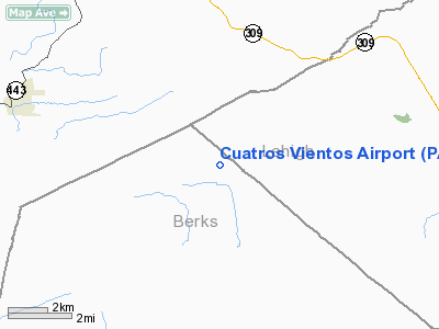
Location & QuickFacts
| FAA Information Effective: | 2008-09-25 |
| Airport Identifier: | PA25 |
| Airport Status: | Operational |
| Longitude/Latitude: | 075-52-25.7200W/40-39-33.3340N
-75.873811/40.659259 (Estimated) |
| Elevation: | 500 ft / 152.40 m (Estimated) |
| Land: | 0 acres |
| From nearest city: | 2 nautical miles E of Quaker City, PA |
| Location: | Berks County, PA |
| Magnetic Variation: | 11W (1985) |
Owner & Manager
| Ownership: | Privately owned |
| Owner: | Ronald B. Howell |
| Address: | Rd 2, Box 150a
Kepton, PA 19529 |
| Phone number: | 215-756-0065 |
| Manager: | Ronald B. Howell |
| Address: | Rd 2, Box 150a
Kepton, PA 19529 |
| Phone number: | 215-756-0065 |
Airport Operations and Facilities
| Airport Use: | Private
PERSONAL USE |
| Segmented Circle: | No |
| Control Tower: | No |
| Sectional chart: | New York |
| Region: | AEA - Eastern |
| Boundary ARTCC: | ZNY - New York |
| Tie-in FSS: | IPT - Williamsport |
| FSS Toll Free: | 1-800-WX-BRIEF |
Runway Information
Runway 05/23
| Dimension: | 1200 x 100 ft / 365.8 x 30.5 m |
| Surface: | TURF, |
| |
Runway 05 |
Runway 23 |
| Traffic Pattern: | Left | Left |
|
Radio Navigation Aids
| ID |
Type |
Name |
Ch |
Freq |
Var |
Dist |
| LQX | NDB | Carbon | | 339.00 | 12W | 10.6 nm |
| HXM | NDB | Humbolt | | 366.00 | 10W | 20.6 nm |
| UKT | NDB | Quakertown | | 208.00 | 12W | 29.9 nm |
| CYE | NDB | Crystal Lake | | 410.00 | 11W | 33.2 nm |
| BZJ | NDB | Bellgrove | | 328.00 | 10W | 33.8 nm |
| DYL | NDB | Doylestown | | 237.00 | 10W | 39.5 nm |
| ING | NDB | Ambler | | 275.00 | 11W | 41.9 nm |
| NXX | NDB | Willow Grove | | 388.00 | 12W | 43.7 nm |
| NXX | TACAN | Willow Grove | 061X | | 10W | 43.5 nm |
| HZL | VOR | Hazleton | | 109.40 | 09W | 22.2 nm |
| ETX | VOR/DME | East Texas | 039X | 110.20 | 09W | 9.9 nm |
| CKZ | VOR/DME | Pennridge | 025Y | 108.85 | 12W | 31.2 nm |
| BWZ | VOR/DME | Broadway | 089X | 114.20 | 11W | 48.6 nm |
| STW | VOR/DME | Stillwater | 033X | 109.60 | 11W | 50.0 nm |
| FJC | VORTAC | Allentown | 122X | 117.50 | 10W | 19.5 nm |
| PTW | VORTAC | Pottstown | 112X | 116.50 | 09W | 29.9 nm |
| RAV | VORTAC | Ravine | 093X | 114.60 | 11W | 33.7 nm |
| LRP | VORTAC | Lancaster | 120X | 117.30 | 09W | 37.6 nm |
| LVZ | VORTAC | Wilkes-barre | 053X | 111.60 | 10W | 37.8 nm |
| MIP | VORTAC | Milton | 029X | 109.20 | 09W | 42.1 nm |
| MXE | VORTAC | Modena | 079X | 113.20 | 09W | 45.5 nm |
| SEG | VORTAC | Selinsgrove | 041X | 110.40 | 08W | 46.7 nm |
| MDT | VOT | Harrisburg International | | 110.00 | | 49.3 nm |
Remarks
- OWNER DESIRES CHARTING.
- PROVIDED RWY 05 IS DISPLACED
Images and information placed above are from
http://www.airport-data.com/airport/PA25/
We thank them for the data!
| General Info
|
| Country |
United States
|
| State |
PENNSYLVANIA
|
| FAA ID |
PA25
|
| Latitude |
40-39-33.334N
|
| Longitude |
075-52-25.720W
|
| Elevation |
500 feet
|
| Near City |
QUAKER CITY
|
We don't guarantee the information is fresh and accurate. The data may
be wrong or outdated.
For more up-to-date information please refer to other sources.
|
|


