 |
|
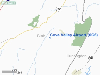
Location & QuickFacts
| FAA Information Effective: | 2008-09-25 |
| Airport Identifier: | 6G6 |
| Airport Status: | Operational |
| Longitude/Latitude: | 078-14-17.0390W/40-27-16.2610N
-78.238066/40.454517 (Estimated) |
| Elevation: | 1156 ft / 352.35 m (Estimated) |
| Land: | 16 acres |
| From nearest city: | 2 nautical miles W of Williamsburg, PA |
| Location: | Blair County, PA |
| Magnetic Variation: | 09W (1985) |
Owner & Manager
| Ownership: | Privately owned |
| Owner: | Christopher H. & Janice M. Bartel |
| Address: | Rd 1, Box 220
Williamsburg, PA 16693 |
| Phone number: | 814-832-2694 |
| Manager: | Christopher H. Bartel |
| Address: | Rd1, Box 220
Williamsburg, PA 16693 |
| Phone number: | 814-832-2694 |
Airport Operations and Facilities
| Airport Use: | Open to public |
| Wind indicator: | Yes |
| Segmented Circle: | No |
| Control Tower: | No |
| Landing fee charge: | No |
| Sectional chart: | Detroit |
| Region: | AEA - Eastern |
| Boundary ARTCC: | ZOB - Cleveland |
| Tie-in FSS: | AOO - Altoona |
| FSS on Airport: | No |
| FSS Toll Free: | 1-800-WX-BRIEF |
| NOTAMs Facility: | AOO (NOTAM-d service avaliable) |
Airport Communications
Airport Services
| Airframe Repair: | MAJOR |
| Power Plant Repair: | MAJOR |
| Bottled Oxygen: | NONE |
| Bulk Oxygen: | NONE |
Runway Information
Runway 04/22
| Dimension: | 2750 x 100 ft / 838.2 x 30.5 m |
| Surface: | TURF, Good Condition |
| |
Runway 04 |
Runway 22 |
| Traffic Pattern: | Right | Left |
| Displaced threshold: | 285.00 ft
RY 04/22 DSPLCD THLDS MKD WITH BLUE CONTRASTING BOUNDARY MARKERS. | 286.00 ft |
| Obstruction: | 10 ft road, 25.0 ft from runway, 2:1 slope to clear
APCH SLOPE 31:1 TO DSPLCD THLD. | 9 ft brush, 5.0 ft from runway, 54 ft right of centerline
APCH SLOPE 21:1 TO DSPLCD THLD. |
|
Radio Navigation Aids
| ID |
Type |
Name |
Ch |
Freq |
Var |
Dist |
| RV | NDB | Stroh | | 407.00 | 10W | 25.6 nm |
| SYS | NDB | Stoystown | | 209.00 | 08W | 38.2 nm |
| INP | NDB | Indiana | | 242.00 | 08W | 39.3 nm |
| BHU | NDB | Benje | | 382.00 | 07W | 47.5 nm |
| AOO | VOR | Altoona | | 108.80 | 07W | 8.3 nm |
| HGR | VOR | Hagerstown | | 109.80 | 07W | 48.8 nm |
| REC | VOR/DME | Revloc | 043X | 110.60 | 09W | 23.9 nm |
| TON | VORTAC | Tyrone | 096X | 114.90 | 07W | 17.4 nm |
| JST | VORTAC | Johnstown | 077X | 113.00 | 06W | 28.5 nm |
| PSB | VORTAC | Philipsburg | 102X | 115.50 | 10W | 29.9 nm |
| THS | VORTAC | St Thomas | 097X | 115.00 | 07W | 34.0 nm |
| ETG | VORTAC | Keating | 107X | 116.00 | 10W | 45.9 nm |
Remarks
- ARPT SAFETY BRIEFING REQUIRED BEFORE LANDING 814-832-2694.
- TURF SOFT DURING SPRING AND AFTER RAINS; NO OPNS WHEN RY IS SOFT OR SNOW COVERED.
- DEER ON & INVOF APRT.
- OCCASIONALLY FARM VEHICLES TRANSVERSE AREA NEAR APCH END OF RY 04.
- BUILT BEFORE 1959.
Images and information placed above are from
http://www.airport-data.com/airport/6G6/
We thank them for the data!
| General Info
|
| Country |
United States
|
| State |
PENNSYLVANIA
|
| FAA ID |
6G6
|
| Latitude |
40-27-16.261N
|
| Longitude |
078-14-17.039W
|
| Elevation |
1156 feet
|
| Near City |
WILLIAMSBURG
|
We don't guarantee the information is fresh and accurate. The data may
be wrong or outdated.
For more up-to-date information please refer to other sources.
|
|


