 |
|
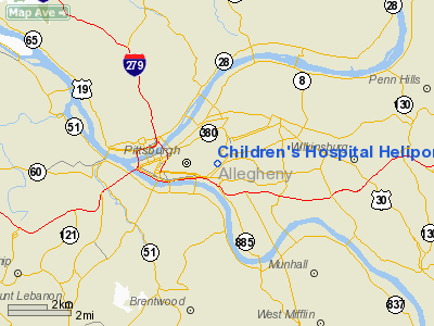
Children's Hospital Heliport |
Location & QuickFacts
| FAA Information Effective: | 2008-09-25 |
| Airport Identifier: | PS78 |
| Airport Status: | Operational |
| Longitude/Latitude: | 079-57-36.1870W/40-26-32.2480N
-79.960052/40.442291 (Estimated) |
| Elevation: | 1124 ft / 342.60 m (Estimated) |
| Land: | 0 acres |
| From nearest city: | 0 nautical miles N of Pittsburgh, PA |
| Location: | Allegheny County, PA |
| Magnetic Variation: | 09W (2000) |
Owner & Manager
| Ownership: | Privately owned |
| Owner: | Children's Hosp Of Pittsburgh |
| Address: | 3705 5th Ave At Desoto St
Pittsburgh, PA 15213 |
| Phone number: | 412-692-5000 |
| Manager: | Children's Hosp Of Pittsburgh |
| Address: | 3705 5th Ave At Desoto St
Pittsburgh, PA 15213 |
| Phone number: | 412-692-5313
OR 412-692-5000. |
Airport Operations and Facilities
| Airport Use: | Private
MEDICAL USE. |
| Wind indicator: | Yes |
| Segmented Circle: | No |
| Control Tower: | No |
| Lighting Schedule: | PHONE REQ
FOR ROTG BCN & PERIMETER LGTS CALL 412-692-5191. |
| Beacon Color: | Clear-Green-Yellow (heliport) |
| Landing fee charge: | Yes |
| Sectional chart: | Detroit |
| Region: | AEA - Eastern |
| Boundary ARTCC: | ZOB - Cleveland |
| Tie-in FSS: | AOO - Altoona |
| FSS on Airport: | No |
| FSS Toll Free: | 1-800-WX-BRIEF |
Runway Information
Helipad H1
| Dimension: | 96 x 48 ft / 29.3 x 14.6 m |
| Surface: | CONC, |
| |
Runway H1 |
Runway |
| Traffic Pattern: | Left | Left |
|
Radio Navigation Aids
| ID |
Type |
Name |
Ch |
Freq |
Var |
Dist |
| MKP | NDB | Mc Keesport | | 287.00 | 07W | 9.7 nm |
| PNU | NDB | Washington County | | 255.00 | 08W | 20.2 nm |
| BHU | NDB | Benje | | 382.00 | 07W | 31.8 nm |
| VV | NDB | Camor | | 299.00 | 08W | 35.1 nm |
| UCP | NDB | Castle | | 272.00 | 09W | 40.6 nm |
| INP | NDB | Indiana | | 242.00 | 08W | 42.4 nm |
| CFX | NDB | Cadiz | | 239.00 | 07W | 49.8 nm |
| AGC | VOR/DME | Allegheny | 037X | 110.00 | 09W | 10.5 nm |
| HLG | VOR/DME | Wheeling | 059X | 112.20 | 07W | 30.0 nm |
| AIR | VOR/DME | Bellaire | 118X | 117.10 | 07W | 46.9 nm |
| CIP | VOR/DME | Clarion | 076X | 112.90 | 06W | 48.1 nm |
| MMJ | VORTAC | Montour | 057X | 112.00 | 08W | 11.0 nm |
| EWC | VORTAC | Ellwood City | 105X | 115.80 | 08W | 25.7 nm |
| IHD | VORTAC | Indian Head | 019X | 108.20 | 06W | 39.4 nm |
Remarks
- PROVIDED FLAG POLE IS OBSTRUCTION LIGHTED.
Images and information placed above are from
http://www.airport-data.com/airport/PS78/
We thank them for the data!
| General Info
|
| Country |
United States
|
| State |
PENNSYLVANIA
|
| FAA ID |
1PS5
|
| Latitude |
39-56-53.406N
|
| Longitude |
075-11-39.645W
|
| Elevation |
167 feet
|
| Near City |
PHILADELPHIA
|
We don't guarantee the information is fresh and accurate. The data may
be wrong or outdated.
For more up-to-date information please refer to other sources.
|
|


