 |
|
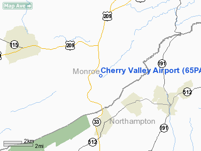
Location & QuickFacts
| FAA Information Effective: | 2008-09-25 |
| Airport Identifier: | 65PA |
| Airport Status: | Operational |
| Longitude/Latitude: | 075-17-46.6530W/40-53-45.3390N
-75.296292/40.895927 (Estimated) |
| Elevation: | 670 ft / 204.22 m (Estimated) |
| Land: | 4 acres |
| From nearest city: | 2 nautical miles W of Saylorsburg, PA |
| Location: | Monroe County, PA |
| Magnetic Variation: | 12W (1990) |
Owner & Manager
| Ownership: | Privately owned |
| Owner: | Robert Irving |
| Address: | 50 Blenheim Dr
Easton, PA 18042 |
| Phone number: | 717-992-7911 |
| Address: |
|
Airport Operations and Facilities
| Airport Use: | Private |
| Wind indicator: | Yes |
| Segmented Circle: | No |
| Control Tower: | No |
| Sectional chart: | New York |
| Region: | AEA - Eastern |
| Boundary ARTCC: | ZNY - New York |
| Tie-in FSS: | IPT - Williamsport |
| FSS Toll Free: | 1-800-WX-BRIEF |
Runway Information
Runway 07/25
| Dimension: | 1710 x 100 ft / 521.2 x 30.5 m |
| Surface: | TURF, |
| |
Runway 07 |
Runway 25 |
| Traffic Pattern: | Left | Right |
| Displaced threshold: | 200.00 ft
07/25 DSPLCD THRS MARKED WITH RY MARKERS. | 350.00 ft |
| Obstruction: | 40 ft wires, 800.0 ft from runway | 30 ft trees, 300.0 ft from runway |
|
Radio Navigation Aids
| ID |
Type |
Name |
Ch |
Freq |
Var |
Dist |
| LQX | NDB | Carbon | | 339.00 | 12W | 21.6 nm |
| UKT | NDB | Quakertown | | 208.00 | 12W | 28.3 nm |
| CYE | NDB | Crystal Lake | | 410.00 | 11W | 30.8 nm |
| HXM | NDB | Humbolt | | 366.00 | 10W | 32.3 nm |
| DYL | NDB | Doylestown | | 237.00 | 10W | 34.6 nm |
| CAT | NDB | Chatham | | 254.00 | 11W | 40.5 nm |
| NXX | NDB | Willow Grove | | 388.00 | 12W | 43.0 nm |
| ING | NDB | Ambler | | 275.00 | 11W | 46.3 nm |
| NXX | TACAN | Willow Grove | 061X | | 10W | 42.7 nm |
| HZL | VOR | Hazleton | | 109.40 | 09W | 38.0 nm |
| STW | VOR/DME | Stillwater | 033X | 109.60 | 11W | 20.3 nm |
| BWZ | VOR/DME | Broadway | 089X | 114.20 | 11W | 22.4 nm |
| ETX | VOR/DME | East Texas | 039X | 110.20 | 09W | 25.9 nm |
| CKZ | VOR/DME | Pennridge | 025Y | 108.85 | 12W | 30.4 nm |
| SBJ | VOR/DME | Solberg | 076X | 112.90 | 10W | 31.5 nm |
| ARD | VOR/DME | Yardley | 019X | 108.20 | 10W | 42.5 nm |
| HUO | VOR/DME | Huguenot | 108X | 116.10 | 11W | 44.4 nm |
| FJC | VORTAC | Allentown | 122X | 117.50 | 10W | 12.5 nm |
| LVZ | VORTAC | Wilkes-barre | 053X | 111.60 | 10W | 28.8 nm |
| LHY | VORTAC | Lake Henry | 045X | 110.80 | 10W | 35.9 nm |
| SAX | VORTAC | Sparta | 104X | 115.70 | 11W | 35.9 nm |
| PTW | VORTAC | Pottstown | 112X | 116.50 | 09W | 42.2 nm |
Remarks
- PRVDD TREES AS SUBMITTED ON LAYOUT SKETCH ARE REMOVED OR LOWERED.
Images and information placed above are from
http://www.airport-data.com/airport/65PA/
We thank them for the data!
| General Info
|
| Country |
United States
|
| State |
PENNSYLVANIA
|
| FAA ID |
65PA
|
| Latitude |
40-53-45.339N
|
| Longitude |
075-17-46.653W
|
| Elevation |
670 feet
|
| Near City |
SAYLORSBURG
|
We don't guarantee the information is fresh and accurate. The data may
be wrong or outdated.
For more up-to-date information please refer to other sources.
|
|


