 |
|
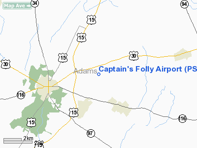
Location & QuickFacts
| FAA Information Effective: | 2008-09-25 |
| Airport Identifier: | PS25 |
| Airport Status: | Operational |
| Longitude/Latitude: | 077-09-53.0000W/39-50-36.3470N
-77.164722/39.843430 (Estimated) |
| Elevation: | 641 ft / 195.38 m (Estimated) |
| Land: | 3 acres |
| From nearest city: | 4 nautical miles E of Gettysburg, PA |
| Location: | Adams County, PA |
| Magnetic Variation: | 10W (1985) |
Owner & Manager
| Ownership: | Privately owned |
| Owner: | Richard J. Sherman |
| Address: | 120 Hoffman Road
Gettysburg, PA 17325 |
| Phone number: | 717-334-8378 |
| Manager: | Richard J. Sherman |
| Address: | 120 Hoffman Road
Gettysburg, PA 17325 |
| Phone number: | 717-334-8378 |
Airport Operations and Facilities
| Airport Use: | Private |
| Wind indicator: | Yes |
| Segmented Circle: | No |
| Control Tower: | No |
| Lighting Schedule: | RDO-CTL |
| Landing fee charge: | No |
| Sectional chart: | Washington |
| Region: | AEA - Eastern |
| Boundary ARTCC: | ZNY - New York |
| Responsible ARTCC: | ZDC - Washington |
| Tie-in FSS: | IPT - Williamsport |
| FSS on Airport: | No |
| FSS Toll Free: | 1-800-WX-BRIEF |
Runway Information
Runway 04/22
| Dimension: | 3175 x 55 ft / 967.7 x 16.8 m |
| Surface: | TURF, Good Condition |
| Edge Lights: | Low |
| |
Runway 04 |
Runway 22 |
| Traffic Pattern: | Left | Left |
| Markings: | Nonstandard, | Nonstandard, |
| Displaced threshold: | 1700.00 ft | 1400.00 ft |
|
Radio Navigation Aids
| ID |
Type |
Name |
Ch |
Freq |
Var |
Dist |
| EUD | NDB | York | | 254.00 | 11W | 14.0 nm |
| FND | NDB | Ellicott | | 371.00 | 11W | 37.9 nm |
| GAI | NDB | Gaithersburg | | 385.00 | 09W | 40.5 nm |
| IUB | NDB | Institute | | 404.00 | 08W | 41.8 nm |
| BZJ | NDB | Bellgrove | | 328.00 | 10W | 45.4 nm |
| MTN | NDB | Martin | | 342.00 | 11W | 48.9 nm |
| BUH | NDB | Anne Arundel | | 260.00 | 10W | 49.4 nm |
| MTN | TACAN | Martin | 068X | | 11W | 46.5 nm |
| FDK | VOR | Frederick | | 109.00 | 08W | 27.7 nm |
| HGR | VOR | Hagerstown | | 109.80 | 07W | 33.1 nm |
| EMI | VORTAC | Westminster | 126X | 117.90 | 08W | 22.6 nm |
| HAR | VORTAC | Harrisburg | 072X | 112.50 | 10W | 27.9 nm |
| THS | VORTAC | St Thomas | 097X | 115.00 | 07W | 36.7 nm |
| MRB | VORTAC | Martinsburg | 058X | 112.10 | 07W | 41.9 nm |
| LRP | VORTAC | Lancaster | 120X | 117.30 | 09W | 43.5 nm |
| BAL | VORTAC | Baltimore | 098X | 115.10 | 11W | 46.7 nm |
| RAV | VORTAC | Ravine | 093X | 114.60 | 11W | 49.9 nm |
| MDT | VOT | Harrisburg International | | 110.00 | | 28.2 nm |
Remarks
- ACTVT LIRL RY 04/22 - 122.850
Images and information placed above are from
http://www.airport-data.com/airport/PS25/
We thank them for the data!
| General Info
|
| Country |
United States
|
| State |
PENNSYLVANIA
|
| FAA ID |
PS25
|
| Latitude |
39-50-36.347N
|
| Longitude |
077-09-53.000W
|
| Elevation |
641 feet
|
| Near City |
GETTYSBURG
|
We don't guarantee the information is fresh and accurate. The data may
be wrong or outdated.
For more up-to-date information please refer to other sources.
|
|


