|
|
Butter Valley Golf Port Airport |
| Butter Valley Golf Port |
| IATA: none – ICAO: none – FAA LID: 7N8 |
| Summary |
| Airport type |
Public |
| Owner/Operator |
John L. Gehman |
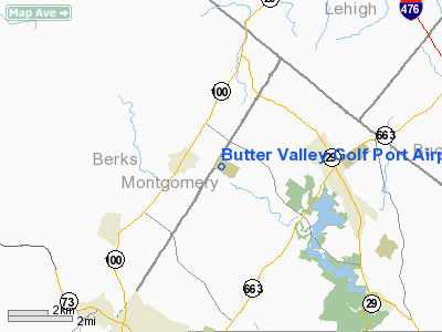
| Location |
Bally, Pennsylvania |
| Elevation AMSL |
500 ft / 152 m |
| Coordinates |
40°23′53″N 075°33′52″W / 40.39806°N 75.56444°W / 40.39806; -75.56444Coordinates: 40°23′53″N 075°33′52″W / 40.39806°N 75.56444°W / 40.39806; -75.56444 |
| Website |
buttervalley.com/airport.htm |
| Runways |
| Direction |
Length |
Surface |
| ft |
m |
| 16/34 |
2,420 |
738 |
Asphalt/Turf |
| Statistics (2008) |
| Aircraft operations |
4,500 |
| Based aircraft |
16 |
| Source: FAA and airport web site |
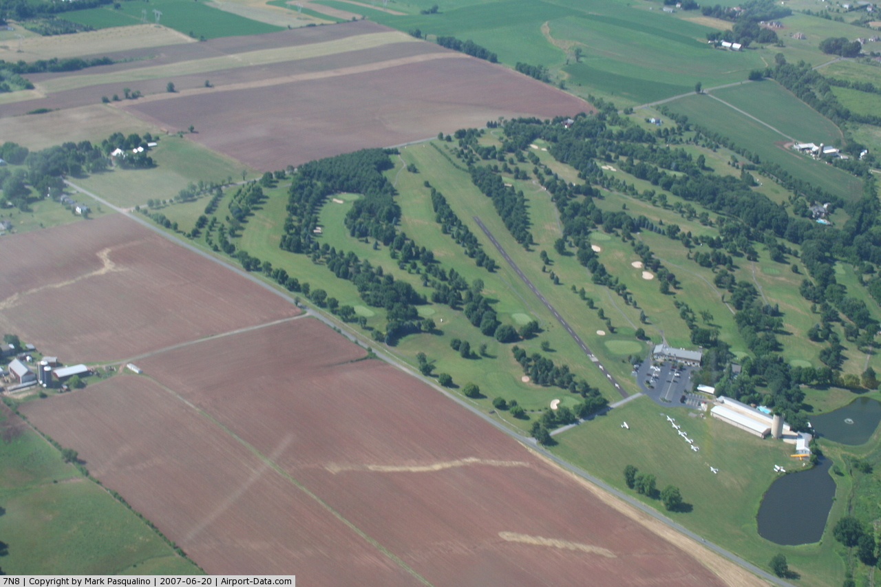
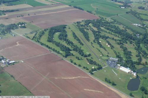
Butter Valley Golf Port (FAA LID: 7N8) is a privately-owned, public-use airport located on the Butter Valley Golf Port golf course, 1 mile (1.6 km) east of the borough of Bally in Montgomery County, Pennsylvania, United States Actually , it is a golf course with a small airstrip on it.
Facilities and aircraft
Butter Valley Golf Port covers an area of 10 acres (4.0 ha) and contains one runway designated 16/34 with a 2,420 feet (740 m) x 85 feet (26 m) asphalt/turf surface which includes a 1,535 feet (468 m) paved section.
For the 12-month period ending April 15, 2008, the airport had 4,500 general aviation aircraft operations, an average of 12 per day. There are 16 aircraft based at this airport: 94% single-engine and 6% multi-engine.
The above content comes from Wikipedia and is published under free licenses – click here to read more.
 |
(Click on the photo to enlarge) |
Location & QuickFacts
| FAA Information Effective: | 2008-09-25 |
| Airport Identifier: | 7N8 |
| Airport Status: | Operational |
| Longitude/Latitude: | 075-33-51.6610W/40-23-53.3520N
-75.564350/40.398153 (Estimated) |
| Elevation: | 500 ft / 152.40 m (Estimated) |
| Land: | 10 acres |
| From nearest city: | 1 nautical miles E of Bally, PA |
| Location: | Montgomery County, PA |
| Magnetic Variation: | 11W (1985) |
Owner & Manager
| Ownership: | Privately owned |
| Owner: | John L Gehman |
| Address: | South 7th St
Bally, PA 19503 |
| Phone number: | 610-845-2491 |
| Manager: | John L. Gehman |
| Address: | South 7th St, Box 207
Bally, PA 19503 |
| Phone number: | 610-845-2491 |
Airport Operations and Facilities
| Airport Use: | Open to public |
| Wind indicator: | Yes |
| Segmented Circle: | No |
| Control Tower: | No |
| Landing fee charge: | No |
| Sectional chart: | New York |
| Region: | AEA - Eastern |
| Boundary ARTCC: | ZNY - New York |
| Tie-in FSS: | IPT - Williamsport |
| FSS on Airport: | No |
| FSS Toll Free: | 1-800-WX-BRIEF |
| NOTAMs Facility: | IPT (NOTAM-d service avaliable) |
Airport Communications
| CTAF: | 122.800 |
| Unicom: | 122.800 |
Airport Services
| Fuel available: | 100LL |
| Airframe Repair: | MINOR |
| Power Plant Repair: | MINOR |
Runway Information
Runway 16/34
| Dimension: | 2420 x 85 ft / 737.6 x 25.9 m |
| Surface: | ASPH-TURF, Good Condition
1535 X 24 ASPH INSERT AT S END; REMAINDER TURF. |
| |
Runway 16 |
Runway 34 |
| Traffic Pattern: | Left | Left |
| Markings: | ,
END MARKED WITH YELLOW WOOD PANELS; TURF RY EDGES MARKED WITH TIRES PAINTED YELLOW. MARKINGS ON PAVED SURFACE FADED. | Basic, Fair Condition |
| Displaced threshold: | 205.00 ft
DSPLCD THLD MKD BY 3 YELLOW TIRES. | 150.00 ft
DSPLCD THLD MKD BY 3 WHITE LINES. |
| Obstruction: | 11 ft road, 9.0 ft from runway, 100 ft right of centerline, 2:1 slope to clear
APCH RATIO 16:1 TO DSPLCD THLD. | 10 ft road, 0.0 ft from runway
APCH RATIO 16:1 TO DSPLCD THLD. |
|
Radio Navigation Aids
| ID |
Type |
Name |
Ch |
Freq |
Var |
Dist |
| UKT | NDB | Quakertown | | 208.00 | 12W | 12.3 nm |
| DYL | NDB | Doylestown | | 237.00 | 10W | 20.6 nm |
| ING | NDB | Ambler | | 275.00 | 11W | 20.8 nm |
| NXX | NDB | Willow Grove | | 388.00 | 12W | 22.9 nm |
| LQX | NDB | Carbon | | 339.00 | 12W | 26.4 nm |
| HXM | NDB | Humbolt | | 366.00 | 10W | 40.6 nm |
| BZJ | NDB | Bellgrove | | 328.00 | 10W | 45.3 nm |
| NXX | TACAN | Willow Grove | 061X | | 10W | 22.7 nm |
| PNE | VOR | North Philadelphia | | 112.00 | 10W | 31.8 nm |
| HZL | VOR | Hazleton | | 109.40 | 09W | 43.1 nm |
| ETX | VOR/DME | East Texas | 039X | 110.20 | 09W | 12.3 nm |
| CKZ | VOR/DME | Pennridge | 025Y | 108.85 | 12W | 12.6 nm |
| ARD | VOR/DME | Yardley | 019X | 108.20 | 10W | 31.3 nm |
| SBJ | VOR/DME | Solberg | 076X | 112.90 | 10W | 39.2 nm |
| BWZ | VOR/DME | Broadway | 089X | 114.20 | 11W | 41.6 nm |
| STW | VOR/DME | Stillwater | 033X | 109.60 | 11W | 47.9 nm |
| PTW | VORTAC | Pottstown | 112X | 116.50 | 09W | 10.6 nm |
| FJC | VORTAC | Allentown | 122X | 117.50 | 10W | 20.4 nm |
| MXE | VORTAC | Modena | 079X | 113.20 | 09W | 29.3 nm |
| LRP | VORTAC | Lancaster | 120X | 117.30 | 09W | 37.3 nm |
| DQO | VORTAC | Dupont | 087X | 114.00 | 10W | 43.3 nm |
| OOD | VORTAC | Woodstown | 075X | 112.80 | 10W | 47.4 nm |
| RAV | VORTAC | Ravine | 093X | 114.60 | 11W | 48.2 nm |
| PHL | VOT | Philadelphia Intl | | 109.80 | | 35.0 nm |
Remarks
- RY 16/34 LIES IN MIDDLE OF GOLF COURSE.
- TREES & SUBSTANTIAL TERRAIN ELEVATION CHANGES WITHIN 125 FT OF EACH RY EDGE.
- VFR OPNS ONLY
Images and information placed above are from
http://www.airport-data.com/airport/7N8/
We thank them for the data!
|
|