 |
|
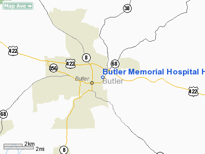
Butler Memorial Hospital Heliport |
Location & QuickFacts
| FAA Information Effective: | 2008-09-25 |
| Airport Identifier: | PA41 |
| Airport Status: | Operational |
| Longitude/Latitude: | 079-52-53.0000W/40-52-00.0000N
-79.881389/40.866667 (Estimated) |
| Elevation: | 1190 ft / 362.71 m (Estimated) |
| Land: | 0 acres |
| From nearest city: | 0 nautical miles N of Butler, PA |
| Location: | Butler County, PA |
| Magnetic Variation: | 09W (1995) |
Owner & Manager
| Ownership: | Privately owned |
| Owner: | Butler Momorial Hospital |
| Address: | 911 E. Brady St
Butler, PA 16001 |
| Phone number: | 412-284-4400 |
| Manager: | Joseph A Stewart |
| Address: | 911 E. Brady St
Butler, PA 16001 |
| Phone number: | 412-284-4400 |
Airport Operations and Facilities
| Airport Use: | Private |
| Wind indicator: | Yes |
| Segmented Circle: | Yes |
| Control Tower: | No |
| Sectional chart: | Detroit |
| Region: | AEA - Eastern |
| Boundary ARTCC: | ZOB - Cleveland |
| Tie-in FSS: | AOO - Altoona |
| FSS Toll Free: | 1-800-WX-BRIEF |
Runway Information
Helipad H1
| Dimension: | 65 x 65 ft / 19.8 x 19.8 m |
| Surface: | ASPH, |
| |
Runway H1 |
Runway |
| Traffic Pattern: | Left | Left |
|
Radio Navigation Aids
| ID |
Type |
Name |
Ch |
Freq |
Var |
Dist |
| UCP | NDB | Castle | | 272.00 | 09W | 26.0 nm |
| MKP | NDB | Mc Keesport | | 287.00 | 07W | 31.1 nm |
| HBD | NDB | Hubbard | | 408.00 | 08W | 34.1 nm |
| INP | NDB | Indiana | | 242.00 | 08W | 39.7 nm |
| BHU | NDB | Benje | | 382.00 | 07W | 40.6 nm |
| PNU | NDB | Washington County | | 255.00 | 08W | 45.3 nm |
| FKL | VOR | Franklin | | 109.60 | 06W | 34.4 nm |
| CIP | VOR/DME | Clarion | 076X | 112.90 | 06W | 25.5 nm |
| AGC | VOR/DME | Allegheny | 037X | 110.00 | 09W | 36.1 nm |
| HLG | VOR/DME | Wheeling | 059X | 112.20 | 07W | 48.1 nm |
| EWC | VORTAC | Ellwood City | 105X | 115.80 | 08W | 15.2 nm |
| MMJ | VORTAC | Montour | 057X | 112.00 | 08W | 26.8 nm |
| YNG | VORTAC | Youngstown | 027X | 109.00 | 05W | 45.5 nm |
Remarks
- PRVDD SECONDARY INGRESS/EGRESS ROUTE (360-180) IS CONFIGURED TO PROVIDE FOR NO PENETRATION OF THE 2:1 TRANSITIONAL SFC BY THE BOILER STACK.
Images and information placed above are from
http://www.airport-data.com/airport/PA41/
We thank them for the data!
| General Info
|
| Country |
United States
|
| State |
PENNSYLVANIA
|
| FAA ID |
PA41
|
| Latitude |
40-52-00.000N
|
| Longitude |
079-52-53.000W
|
| Elevation |
1190 feet
|
| Near City |
BUTLER
|
We don't guarantee the information is fresh and accurate. The data may
be wrong or outdated.
For more up-to-date information please refer to other sources.
|
|


