 |
|
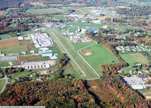 |
(Click on the photo to enlarge) |
Location & QuickFacts
| FAA Information Effective: | 2008-09-25 |
| Airport Identifier: | 3G9 |
| Airport Status: | Operational |
| Longitude/Latitude: | 079-58-29.2070W/40-51-09.2320N
-79.974780/40.852564 (Estimated) |
| Elevation: | 1333 ft / 406.30 m (Estimated) |
| Land: | 56 acres |
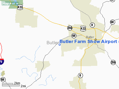
| From nearest city: | 3 nautical miles W of Butler, PA |
| Location: | Butler County, PA |
| Magnetic Variation: | 08W (1985) |
Owner & Manager
| Ownership: | Privately owned |
| Owner: | Butler Farm Show, Inc. |
| Address: | 627 Evans City Rd
Butler, PA 16001 |
| Phone number: | 724-482-4626 |
| Manager: | Don Cravener |
| Address: | 627 Evans City Rd
Butler, PA 16001 |
| Phone number: | 724-991-9724
ASST MGR KEN LAUGHLIN, 724-991-2208. |
Airport Operations and Facilities
| Airport Use: | Open to public |
| Wind indicator: | Yes
LGTD WND "T" |
| Segmented Circle: | No |
| Control Tower: | No |
| Lighting Schedule: | DUSK-DAWN
LIRL RY 18/36 OPERS DUSK-0000. AFT 0000 ACTVT LIRL RY 18/36 - CTAF. |
| Beacon Color: | Clear-Green (lighted land airport) |
| Landing fee charge: | No |
| Sectional chart: | Detroit |
| Region: | AEA - Eastern |
| Boundary ARTCC: | ZOB - Cleveland |
| Tie-in FSS: | AOO - Altoona |
| FSS on Airport: | No |
| FSS Toll Free: | 1-800-WX-BRIEF |
| NOTAMs Facility: | AOO (NOTAM-d service avaliable) |
Airport Communications
| CTAF: | 122.700 |
| Unicom: | 122.700 |
Airport Services
| Fuel available: | 100LL |
| Airframe Repair: | NONE |
| Power Plant Repair: | NONE |
| Bottled Oxygen: | NONE |
| Bulk Oxygen: | NONE |
Runway Information
Runway 18/36
| Dimension: | 2580 x 38 ft / 786.4 x 11.6 m |
| Surface: | ASPH, Fair Condition |
| Weight Limit: | Single wheel: 9000 lbs.
SINGLE WHEEL CAPACITY 9000 LBS PER ARPT MGR. |
| Edge Lights: | Low
RWY 18/36 LGTD THLD RY 18 DISPLACED 180 FT; LGTD THLD RY 36 DISPLACED 123 FT. LIRL NONSTD DISTANCE FM RY EDGE. |
| |
Runway 18 |
Runway 36 |
| Traffic Pattern: | Left | Left |
| Markings: | Basic, Good Condition
RY 18 DSPLCD THLD MRKNGS ARE YELLOW. | Basic, Good Condition
RY 36 DSPLCD THLD MRKGS ARE YELLOW. |
| Displaced threshold: | 180.00 ft | 123.00 ft |
| Obstruction: | 18 ft pole, 213.0 ft from runway, 74 ft right of centerline
APCH SLOPE 20:1 TO DSPLCD THLD TO POWERLINE.
+9' RD 149' FM THR 86'R. | 73 ft trees, 693.0 ft from runway, 172 ft left of centerline, 6:1 slope to clear
APCH SLOPE 11:1 TO DSPLCD THLD.
RY 36 HAS +17 FT TREES 174 FT FM THLD, 73 FT RT; +12 FT ROAD 99 FT FM THLD ON EXTDD CNTRLN; +6 FT BRUSH 171 FT FM THLD, 13 FT LEFT; +26 FT TREES 161 FT FM THLD, 87 FT LEFT. |
|
Radio Navigation Aids
| ID |
Type |
Name |
Ch |
Freq |
Var |
Dist |
| UCP | NDB | Castle | | 272.00 | 09W | 22.5 nm |
| HBD | NDB | Hubbard | | 408.00 | 08W | 31.0 nm |
| MKP | NDB | Mc Keesport | | 287.00 | 07W | 31.2 nm |
| BHU | NDB | Benje | | 382.00 | 07W | 43.0 nm |
| PNU | NDB | Washington County | | 255.00 | 08W | 43.4 nm |
| INP | NDB | Indiana | | 242.00 | 08W | 43.5 nm |
| FKL | VOR | Franklin | | 109.60 | 06W | 35.6 nm |
| CIP | VOR/DME | Clarion | 076X | 112.90 | 06W | 29.3 nm |
| AGC | VOR/DME | Allegheny | 037X | 110.00 | 09W | 34.6 nm |
| HLG | VOR/DME | Wheeling | 059X | 112.20 | 07W | 44.8 nm |
| EWC | VORTAC | Ellwood City | 105X | 115.80 | 08W | 10.9 nm |
| MMJ | VORTAC | Montour | 057X | 112.00 | 08W | 24.1 nm |
| YNG | VORTAC | Youngstown | 027X | 109.00 | 05W | 42.8 nm |
Remarks
- +22 FT MKD PLINE 292 FT FM RY 18 THR ON EXTDD CNTRLN.
- BIRD ACTVTY INVOF OF RY.
- ULTRALIGHT OPNS PROHIBITED.
- VFR OPNS ONLY
Images and information placed above are from
http://www.airport-data.com/airport/3G9/
We thank them for the data!
| General Info
|
| Country |
United States
|
| State |
PENNSYLVANIA
|
| FAA ID |
3G9
|
| Latitude |
40-51-09.232N
|
| Longitude |
079-58-29.207W
|
| Elevation |
1333 feet
|
| Near City |
BUTLER
|
We don't guarantee the information is fresh and accurate. The data may
be wrong or outdated.
For more up-to-date information please refer to other sources.
|
|


