 |
|
| Bradford Regional Airport |
 |
| IATA: BFD – ICAO: KBFD – FAA LID: BFD |
| Summary |
| Airport type |
Public |
| Owner |
Bradford Airport Authority |
| Serves |
Bradford, Pennsylvania |
| Location |
Lewis Run, Pennsylvania |
| Elevation AMSL |
2,143 ft / 653 m |
| Coordinates |
41°48′11″N 078°38′24″W / 41.80306°N 78.64°W / 41.80306; -78.64 |
| Website |
www.BradfordAirport.net |
| Runways |
| Direction |
Length |
Surface |
| ft |
m |
| 5/23 |
4,500 |
1,372 |
Asphalt |
| 14/32 |
6,309 |
1,923 |
Asphalt |
| Statistics (2005) |
| Aircraft operations |
18,882 |
| Based aircraft |
25 |
| Source: Federal Aviation Administration |
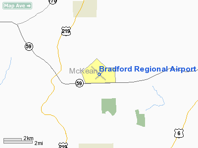
Bradford Regional Airport (IATA: BFD, ICAO: KBFD, FAA LID: BFD) is a public airport located in Lewis Run, 10 miles (16 km) south of the central business district of Bradford, a city in McKean County, Pennsylvania, United States. The airport serves Pennsylvania and Western New York. It offers limited commercial service, subsidized by the Essential Air Service program. Facilities and aircraft
Bradford Regional Airport covers an area of 1,000 acres (405 ha) which contains two asphalt paved runways: 5/23 measuring : 4,500 x 100 ft. (1,372 x 30 m) and 14/32 measuring 6,309 x 150 ft. (1,923 x 46 m).
For the 12-month period ending December 31, 2005, the airport had 18,882 aircraft operations, an average of 51 per day: 77% general aviation, 17% scheduled commercial, 4% air taxi and 2% military. There are 25 aircraft based at this airport: 24 single engine and 1 ultralight.
Airline and destination
| Airlines |
Destinations |
| Continental Connection operated by Gulfstream International Airlines |
Jamestown, Cleveland |
The above content comes from Wikipedia and is published under free licenses – click here to read more.
Location & QuickFacts
| FAA Information Effective: | 2008-09-25 |
| Airport Identifier: | BFD |
| Airport Status: | Operational |
| Longitude/Latitude: | 078-38-24.4350W/41-48-11.0440N
-78.640121/41.803068 (Estimated) |
| Elevation: | 2143 ft / 653.19 m (Surveyed) |
| Land: | 1000 acres |
| From nearest city: | 10 nautical miles S of Bradford, PA |
| Location: | Mc Kean County, PA |
| Magnetic Variation: | 08W (1975) |
Owner & Manager
| Ownership: | Publicly owned |
| Owner: | Bradford Regional Arpt Auth |
| Address: | 212 Airport Dr Suite E
Lewis Run, PA 16738 |
| Phone number: | 814-368-5928 |
| Manager: | Thomas Frungillo |
| Address: | 212 Airport Dr Suite E
Lewis Run, PA 16738 |
| Phone number: | 814-368-5928 |
Airport Operations and Facilities
| Airport Use: | Open to public |
| Wind indicator: | Yes |
| Segmented Circle: | No |
| Control Tower: | No |
| Lighting Schedule: | RDO-CTL
ACTVT REIL RYS 05, 14 & 23; MALSR RY 32; HIRL RY 14/32; MIRL RY 05/23; VASI 14 & 23; TWY LGTS - CTAF. |
| Beacon Color: | Clear-Green (lighted land airport) |
| Landing fee charge: | Yes |
| Sectional chart: | Detroit |
| Region: | AEA - Eastern |
| Boundary ARTCC: | ZOB - Cleveland |
| Tie-in FSS: | AOO - Altoona |
| FSS on Airport: | No |
| FSS Toll Free: | 1-800-WX-BRIEF |
| NOTAMs Facility: | BFD (NOTAM-d service avaliable) |
| Certification type/date: | I A S 05/1973
PPR 24 HRS FOR UNSKED ACR OPNS WITH MORE THAN 30 PSGR SEATS; CALL AMGR 814-368-5928. AFTER 2000, FOR EMERGENCIES CALL 814-465-9998. |
| Federal Agreements: | NGHY3 |
Airport Communications
| CTAF: | 123.075 |
| Unicom: | 123.075 |
Airport Services
| Fuel available: | 100LLA |
| Airframe Repair: | MINOR |
| Power Plant Repair: | MINOR |
| Bottled Oxygen: | NONE |
| Bulk Oxygen: | NONE |
Runway Information
Runway 05/23
| Dimension: | 4500 x 100 ft / 1371.6 x 30.5 m |
| Surface: | ASPH, Good Condition |
| Surface Treatment: | Saw-cut or plastic Grooved |
| Weight Limit: | Single wheel: 48000 lbs.
Dual wheel: 60000 lbs. |
| Edge Lights: | Medium |
| |
Runway 05 |
Runway 23 |
| Longitude: | 078-38-41.9270W | 078-38-00.7540W |
| Latitude: | 41-47-52.7980N | 41-48-24.8380N |
| Elevation: | 2128.00 ft | 2143.00 ft |
| Alignment: | 44 | 127 |
| Traffic Pattern: | Left | Left |
| Markings: | Basic, Fair Condition | Basic, Fair Condition |
| Crossing Height: | 0.00 ft | 30.00 ft |
| VASI: | | 4-box on left side
VASI OTS INDEFLY. |
| Visual Glide Angle: | 0.00° | 3.00° |
| Runway End Identifier: | Yes | Yes |
| Obstruction: | 81 ft trees, 1345.0 ft from runway, 379 ft right of centerline, 14:1 slope to clear | 58 ft trees, 1181.0 ft from runway, 374 ft right of centerline, 17:1 slope to clear |
|
Runway 14/32
| Dimension: | 6309 x 150 ft / 1923.0 x 45.7 m |
| Surface: | ASPH, Good Condition |
| Surface Treatment: | Saw-cut or plastic Grooved |
| Weight Limit: | Single wheel: 48000 lbs.
Dual wheel: 60000 lbs.
Dual tandem wheel: 92000 lbs. |
| Edge Lights: | High |
| |
Runway 14 |
Runway 32 |
| Longitude: | 078-38-55.7000W | 078-37-55.6300W |
| Latitude: | 41-48-33.5300N | 41-47-50.3400N |
| Elevation: | 2109.00 ft | 2100.00 ft |
| Alignment: | 127 | 127 |
| ILS Type: | | ILS
|
| Traffic Pattern: | Left | Left |
| Markings: | Precision instrument, Good Condition
CNTRLN FADED. | Precision instrument, Good Condition
CNTRLN, THLD & TDZ MARKINGS FADED. |
| Crossing Height: | 42.00 ft | 0.00 ft |
| VASI: | 4-box on left side | |
| Visual Glide Angle: | 3.00° | 0.00° |
| Approach lights: | | MALSR
MALSR UNMONITORED. |
| Runway End Identifier: | Yes | |
| Obstruction: | 55 ft trees, 1131.0 ft from runway, 511 ft right of centerline, 17:1 slope to clear | 28 ft pole, 1204.0 ft from runway, 372 ft left of centerline, 36:1 slope to clear |
|
Radio Navigation Aids
| ID |
Type |
Name |
Ch |
Freq |
Var |
Dist |
| LYS | NDB | Olean | | 360.00 | 09W | 31.9 nm |
| EL | NDB | Halos | | 269.00 | 09W | 37.3 nm |
| ORJ | NDB | Corry | | 258.00 | 09W | 45.6 nm |
| BFD | VOR/DME | Bradford | 113X | 116.60 | 07W | 1.4 nm |
| JHW | VOR/DME | Jamestown | 094X | 114.70 | 07W | 31.6 nm |
| ELZ | VORTAC | Wellsville | 051X | 111.40 | 09W | 33.4 nm |
| SLT | VORTAC | Slate Run | 086X | 113.90 | 08W | 34.8 nm |
| TDT | VORTAC | Tidioute | 123X | 117.60 | 09W | 35.3 nm |
| ETG | VORTAC | Keating | 107X | 116.00 | 10W | 41.8 nm |
Remarks
- DEER & BIRDS ON & INVOF ARPT.
- AIRCRAFT DEICING AVAIL
- IN OPERN PRIOR TO 1959.
Images and information placed above are from
http://www.airport-data.com/airport/BFD/
We thank them for the data!
| General Info
|
| Country |
United States
|
| State |
PENNSYLVANIA
|
| FAA ID |
BFD
|
| Latitude |
41-48-11.044N
|
| Longitude |
078-38-24.435W
|
| Elevation |
2143 feet
|
| Near City |
BRADFORD
|
We don't guarantee the information is fresh and accurate. The data may
be wrong or outdated.
For more up-to-date information please refer to other sources.
|
|


