 |
|
| Bradford County Airport |
| IATA: none – ICAO: none – FAA LID: N27 |
| Summary |
| Airport type |
Public |
| Owner |
Bradford County Airport Authority |
| Serves |
Bradford County, Pennsylvania |
| Location |
Towanda, Pennsylvania |
| Elevation AMSL |
730 ft / 223 m |
| Coordinates |
41°44′24″N 076°26′50″W / 41.74°N 76.44722°W / 41.74; -76.44722 |
| Website |
BradfordCountyAirport.com |
| Runways |
| Direction |
Length |
Surface |
| ft |
m |
| 5/23 |
4,300 |
1,311 |
Asphalt |
| Statistics (2006) |
| Aircraft operations |
23,100 |
| Source: FAA and airport website |
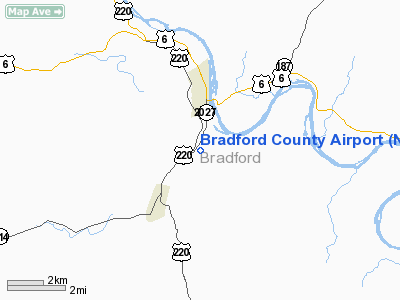
Bradford County Airport (FAA LID: N27) is a public-use airport located two miles (3 km) south of the central business district of Towanda, a borough in and the county seat of Bradford County, Pennsylvania, United States. It is owned by the Bradford County Airport Authority.
Facilities and aircraft
Bradford County Airport covers an area of 250 acres (101 ha) which contains one asphalt paved runway (5/23) measuring 4,300 x 75 ft (1,311 x 23 m). For the 12-month period ending September 30, 2006, the airport had 23,100 aircraft operations, an average of 63 per day: 99.6% general aviation and 0.4% military.
The above content comes from Wikipedia and is published under free licenses – click here to read more.
Location & QuickFacts
| FAA Information Effective: | 2008-09-25 |
| Airport Identifier: | N27 |
| Airport Status: | Operational |
| Longitude/Latitude: | 076-26-49.6740W/41-44-24.0350N
-76.447132/41.740010 (Estimated) |
| Elevation: | 730 ft / 222.50 m (Surveyed) |
| Land: | 250 acres |
| From nearest city: | 2 nautical miles S of Towanda, PA |
| Location: | Bradford County, PA |
| Magnetic Variation: | 12W (2000) |
Owner & Manager
| Ownership: | Publicly owned |
| Owner: | Bradford County Airport Authority |
| Address: | Rd 2, Box 69a
Towanda, PA 18848 |
| Phone number: | 570-265-4900 |
| Manager: | Carl W. Lafy |
| Address: | Rd 2, Box 69a
Towanda, PA 18848 |
| Phone number: | 570-265-2629 |
Airport Operations and Facilities
| Airport Use: | Open to public |
| Wind indicator: | Yes |
| Segmented Circle: | Yes |
| Control Tower: | No |
| Lighting Schedule: | DUSK-DAWN
ACTVT HIRL AND REIL RY 05/23 - 123.0. |
| Beacon Color: | Clear-Green (lighted land airport) |
| Landing fee charge: | No |
| Sectional chart: | New York |
| Region: | AEA - Eastern |
| Boundary ARTCC: | ZNY - New York |
| Tie-in FSS: | IPT - Williamsport |
| FSS on Airport: | No |
| FSS Toll Free: | 1-800-WX-BRIEF |
| NOTAMs Facility: | IPT (NOTAM-d service avaliable) |
| Federal Agreements: | N1 |
Airport Communications
| CTAF: | 123.000 |
| Unicom: | 123.000 |
Airport Services
| Fuel available: | 100LLA |
| Airframe Repair: | MAJOR |
| Power Plant Repair: | MAJOR |
| Bottled Oxygen: | LOW |
| Bulk Oxygen: | NONE |
Runway Information
Runway 05/23
| Dimension: | 4300 x 75 ft / 1310.6 x 22.9 m |
| Surface: | ASPH, Good Condition |
| Weight Limit: | Single wheel: 12000 lbs. |
| Edge Lights: | High |
| |
Runway 05 |
Runway 23 |
| Longitude: | 076-27-05.9700W | 076-26-33.3780W |
| Latitude: | 41-44-06.6500N | 41-44-41.3780N |
| Elevation: | 730.00 ft | 714.00 ft |
| Alignment: | 35 | 127 |
| Traffic Pattern: | Left | Left |
| Markings: | Non-precision instrument, Good Condition | Non-precision instrument, Good Condition |
| Crossing Height: | 41.00 ft | 37.00 ft |
| VASI: | 2-light PAPI on left side | 2-light PAPI on left side |
| Visual Glide Angle: | 3.00° | 3.00° |
| Runway End Identifier: | Yes | Yes |
| Obstruction: | 93 ft trees, 2800.0 ft from runway, 6 ft right of centerline, 28:1 slope to clear | 93 ft trees, 2941.0 ft from runway, 590 ft right of centerline, 29:1 slope to clear |
|
Radio Navigation Aids
| ID |
Type |
Name |
Ch |
Freq |
Var |
Dist |
| PIX | NDB | Picture Rocks | | 344.00 | 09W | 30.3 nm |
| ALP | NDB | Alpine | | 245.00 | 12W | 33.1 nm |
| CYE | NDB | Crystal Lake | | 410.00 | 11W | 42.2 nm |
| HXM | NDB | Humbolt | | 366.00 | 10W | 49.5 nm |
| HZL | VOR | Hazleton | | 109.40 | 09W | 48.2 nm |
| FQM | VOR/DME | Williamsport | 091X | 114.40 | 09W | 28.3 nm |
| ULW | VOR/DME | Elmira | 033Y | 109.65 | 12W | 33.5 nm |
| SFK | VOR/DME | Stonyfork | 023X | 108.60 | 08W | 43.7 nm |
| ITH | VOR/DME | Ithaca | 055X | 111.80 | 10W | 45.4 nm |
| CFB | VORTAC | Binghamton | 059X | 112.20 | 10W | 28.7 nm |
| LVZ | VORTAC | Wilkes-barre | 053X | 111.60 | 10W | 44.2 nm |
| MIP | VORTAC | Milton | 029X | 109.20 | 09W | 44.2 nm |
| LHY | VORTAC | Lake Henry | 045X | 110.80 | 10W | 46.2 nm |
Remarks
- ULTRALIGHT ACTIVITY ON AND INVOF.
Images and information placed above are from
http://www.airport-data.com/airport/N27/
We thank them for the data!
| General Info
|
| Country |
United States
|
| State |
PENNSYLVANIA
|
| FAA ID |
N27
|
| Latitude |
41-44-24.035N
|
| Longitude |
076-26-49.674W
|
| Elevation |
730 feet
|
| Near City |
TOWANDA
|
We don't guarantee the information is fresh and accurate. The data may
be wrong or outdated.
For more up-to-date information please refer to other sources.
|
|


