 |
|
| Bedford County Airport |
| IATA: none – ICAO: KHMZ – FAA LID: HMZ |
| Summary |
| Airport type |
Public |
| Owner |
Bedford County Airport Authority |
| Serves |
Bedford, Pennsylvania |
| Elevation AMSL |
1,162 ft / 354 m |
| Coordinates |
40°05′10″N 078°30′48.6″W / 40.08611°N 78.5135°W / 40.08611; -78.5135 |
| Runways |
| Direction |
Length |
Surface |
| ft |
m |
| 14/32 |
5,005 |
1,526 |
Asphalt |
| Statistics (2009) |
| Aircraft operations |
14,700 |
| Based aircraft |
24 |
| Source: Federal Aviation Administration |
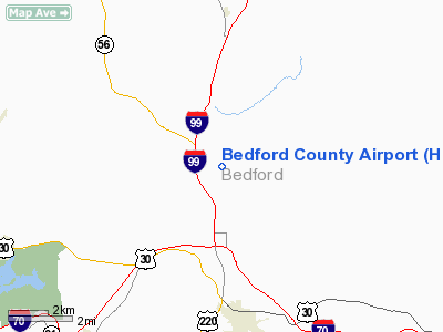
Bedford County Airport (ICAO: KHMZ, FAA LID: HMZ) is a public use airport in Bedford County, Pennsylvania, United States. It is owned by the Bedford County Airport Authority and is located four nautical miles (7.4 km) north of the central business district of the borough of Bedford, Pennsylvania.
Although most U.S. airports use the same three-letter location identifier for the FAA and IATA, this airport is assigned HMZ by the FAA but has no designation from the IATA.
Facilities and aircraft
Bedford County Airport covers an area of 168 acres (59.9 ha) at an elevation of 1,162 feet (354 m) above mean sea level. It has one runway designated 14/32 with an asphalt surface measuring 5,005 by 75 feet (1,526 x 23 m).
For the 12-month period ending February 5, 2009, the airport had 14,700 aircraft operations, an average of 40 per day: 88% general aviation, 8% air taxi and 3% military. At that time there were 24 aircraft based at this airport: 67% single-engine, 8% multi-engine and 21% jet and 4% gliders.
The above content comes from Wikipedia and is published under free licenses – click here to read more.
Location & QuickFacts
| FAA Information Effective: | 2008-09-25 |
| Airport Identifier: | HMZ |
| Airport Status: | Operational |
| Longitude/Latitude: | 078-30-48.6000W/40-05-10.0000N
-78.513500/40.086111 (Estimated) |
| Elevation: | 1162 ft / 354.18 m (Surveyed) |
| Land: | 168 acres |
| From nearest city: | 4 nautical miles N of Bedford, PA |
| Location: | Bedford County, PA |
| Magnetic Variation: | 09W (1995) |
Owner & Manager
| Ownership: | Publicly owned |
| Owner: | Bedford Co Air Ind Park Auth |
| Address: | Po Box 155
Bedford, PA 15522 |
| Phone number: | 814-623-0704 |
| Manager: | Ray Jennings |
| Address: | Po Box 155
Bedford, PA 15522 |
| Phone number: | 814-623-0704 |
Airport Operations and Facilities
| Airport Use: | Open to public |
| Wind indicator: | Yes |
| Segmented Circle: | Yes |
| Control Tower: | No |
| Lighting Schedule: | DUSK-DAWN
ACTVT MIRL RY 14/32 & REIL RYS 14 & 32 - CTAF. PAPI RYS 14 & 32 REMAIN ON. |
| Beacon Color: | Clear-Green (lighted land airport) |
| Sectional chart: | Washington |
| Region: | AEA - Eastern |
| Boundary ARTCC: | ZOB - Cleveland |
| Tie-in FSS: | AOO - Altoona |
| FSS on Airport: | No |
| FSS Toll Free: | 1-800-WX-BRIEF |
| NOTAMs Facility: | AOO (NOTAM-d service avaliable) |
| Federal Agreements: | NGY |
Airport Communications
| CTAF: | 122.700 |
| Unicom: | 122.700 |
Airport Services
| Fuel available: | 100LLA |
| Airframe Repair: | MAJOR |
| Power Plant Repair: | MAJOR |
| Bulk Oxygen: | HIGH |
Runway Information
Runway 14/32
| Dimension: | 5005 x 75 ft / 1525.5 x 22.9 m |
| Surface: | ASPH, Good Condition |
| Weight Limit: | Single wheel: 38000 lbs.
Dual wheel: 60000 lbs.
Dual tandem wheel: 100000 lbs. |
| Edge Lights: | Medium |
| |
Runway 14 |
Runway 32 |
| Longitude: | 078-31-14.1070W | 078-30-23.0878W |
| Latitude: | 40-05-25.1365N | 40-04-54.9631N |
| Elevation: | 1156.00 ft | 1160.00 ft |
| Alignment: | 127 | 127 |
| Traffic Pattern: | Right | Left |
| Markings: | Non-precision instrument, Good Condition
RY 14 MKGS FADED. | Non-precision instrument, Good Condition |
| Crossing Height: | 50.00 ft | 50.00 ft |
| VASI: | 2-light PAPI on left side | 2-light PAPI on left side |
| Visual Glide Angle: | 3.00° | 4.00° |
| Runway End Identifier: | Yes | Yes |
| Obstruction: | , 50:1 slope to clear | 211 ft hill, 4628.0 ft from runway, 816 ft right of centerline, 22:1 slope to clear |
|
Radio Navigation Aids
| ID |
Type |
Name |
Ch |
Freq |
Var |
Dist |
| SYS | NDB | Stoystown | | 209.00 | 08W | 18.5 nm |
| CBE | NDB | Cumberland | | 317.00 | 07W | 28.4 nm |
| BHU | NDB | Benje | | 382.00 | 07W | 38.9 nm |
| INP | NDB | Indiana | | 242.00 | 08W | 41.4 nm |
| RV | NDB | Stroh | | 407.00 | 10W | 48.3 nm |
| AOO | VOR | Altoona | | 108.80 | 07W | 17.3 nm |
| HGR | VOR | Hagerstown | | 109.80 | 07W | 38.3 nm |
| REC | VOR/DME | Revloc | 043X | 110.60 | 09W | 29.7 nm |
| GRV | VOR/DME | Grantsville | 070X | 112.30 | 06W | 36.7 nm |
| JST | VORTAC | Johnstown | 077X | 113.00 | 06W | 20.2 nm |
| THS | VORTAC | St Thomas | 097X | 115.00 | 07W | 27.5 nm |
| IHD | VORTAC | Indian Head | 019X | 108.20 | 06W | 39.5 nm |
| TON | VORTAC | Tyrone | 096X | 114.90 | 07W | 39.9 nm |
Remarks
- HIGH TERRAIN (MTN RIDGES) SOUTHEAST OF ARPT LGTD WITH RED OBSTRUCTION LGTS.
Images and information placed above are from
http://www.airport-data.com/airport/HMZ/
We thank them for the data!
| General Info
|
| Country |
United States
|
| State |
PENNSYLVANIA
|
| FAA ID |
HMZ
|
| Latitude |
40-05-07.327N
|
| Longitude |
078-30-43.984W
|
| Elevation |
1161 feet
|
| Near City |
BEDFORD
|
We don't guarantee the information is fresh and accurate. The data may
be wrong or outdated.
For more up-to-date information please refer to other sources.
|
|


