 |
|
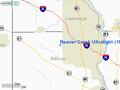
Beaver Creek Ultralight Airport |
Location & QuickFacts
| FAA Information Effective: | 2008-09-25 |
| Airport Identifier: | 1PA5 |
| Airport Status: | Operational |
| Longitude/Latitude: | 080-24-49.2400W/40-49-48.8800N
-80.413678/40.830244 (Estimated) |
| Elevation: | 928 ft / 282.85 m (Estimated) |
| Land: | 16 acres |
| From nearest city: | 1 nautical miles SW of New Galilee, PA |
| Location: | Beaver County, PA |
| Magnetic Variation: | 08W (1995) |
Owner & Manager
| Ownership: | Privately owned |
| Owner: | Joe Albano |
| Address: | Box 197
New Galilee, PA 16141 |
| Phone number: | 412-336-5432 |
| Manager: | Joe Albano |
| Address: | Box 197
New Galilee, PA 16141 |
| Phone number: | 412-336-5432 |
Airport Operations and Facilities
| Airport Use: | Private |
| Wind indicator: | Yes |
| Segmented Circle: | No |
| Control Tower: | No |
| Sectional chart: | Detroit |
| Region: | AEA - Eastern |
| Boundary ARTCC: | ZOB - Cleveland |
| Tie-in FSS: | AOO - Altoona |
| FSS Toll Free: | 1-800-WX-BRIEF |
Runway Information
Runway 12/30
| Dimension: | 1400 x 130 ft / 426.7 x 39.6 m |
| Surface: | TURF, |
| |
Runway 12 |
Runway 30 |
| Longitude: | 080-24-58.2500W | 080-24-40.2400W |
| Latitude: | 40-49-49.9100N | 40-49-47.8400N |
| Elevation: | 920.00 ft | 922.00 ft |
| Traffic Pattern: | Left | Left |
| Markings: | Nonstandard, | , |
| Obstruction: | 50 ft gnd, 700.0 ft from runway | 50 ft plines, 700.0 ft from runway |
|
Radio Navigation Aids
| ID |
Type |
Name |
Ch |
Freq |
Var |
Dist |
| UCP | NDB | Castle | | 272.00 | 09W | 11.6 nm |
| HBD | NDB | Hubbard | | 408.00 | 08W | 20.1 nm |
| TSO | NDB | Tolson | | 395.00 | 07W | 34.3 nm |
| MKP | NDB | Mc Keesport | | 287.00 | 07W | 40.6 nm |
| PNU | NDB | Washington County | | 255.00 | 08W | 42.8 nm |
| CFX | NDB | Cadiz | | 239.00 | 07W | 45.0 nm |
| AK | NDB | Akron | | 362.00 | 07W | 46.5 nm |
| FKL | VOR | Franklin | | 109.60 | 06W | 44.4 nm |
| HLG | VOR/DME | Wheeling | 059X | 112.20 | 07W | 35.0 nm |
| AGC | VOR/DME | Allegheny | 037X | 110.00 | 09W | 37.3 nm |
| ACO | VOR/DME | Akron | 091X | 114.40 | 04W | 39.5 nm |
| BSV | VOR/DME | Briggs | 071X | 112.40 | 04W | 46.7 nm |
| CIP | VOR/DME | Clarion | 076X | 112.90 | 06W | 47.3 nm |
| EWC | VORTAC | Ellwood City | 105X | 115.80 | 08W | 9.2 nm |
| MMJ | VORTAC | Montour | 057X | 112.00 | 08W | 22.9 nm |
| YNG | VORTAC | Youngstown | 027X | 109.00 | 05W | 32.3 nm |
| CAK | VOT | Akron/canton Regional | | 110.60 | | 47.0 nm |
Remarks
- PRVDD DAY VFR ONLY, ULTRALGT USE ONLY, 20:1 APCH SLOPE, MINIMIZE NOISE OVER NEARBY RESIDENCES.
Images and information placed above are from
http://www.airport-data.com/airport/1PA5/
We thank them for the data!
| General Info
|
| Country |
United States
|
| State |
PENNSYLVANIA
|
| FAA ID |
1PA5
|
| Latitude |
40-44-49.220N
|
| Longitude |
080-24-49.230W
|
| Elevation |
1000 feet
|
| Near City |
NEW GALILEE
|
We don't guarantee the information is fresh and accurate. The data may
be wrong or outdated.
For more up-to-date information please refer to other sources.
|
|


