 |
|
Arnold Palmer Rgnl Airport |
| Arnold Palmer Regional Airport |
| IATA: LBE – ICAO: KLBE – FAA LID: LBE |
| Summary |
| Airport type |
Public |
| Owner |
Westmoreland County Airport Authority |
| Serves |
Latrobe, Pennsylvania |
| Elevation AMSL |
1,199 ft / 365 m |
| Coordinates |
40°16′29″N 079°24′24″W / 40.27472°N 79.40667°W / 40.27472; -79.40667 |
| Website |
PalmerAirport.com |
| Runways |
| Direction |
Length |
Surface |
| ft |
m |
| 3/21 |
3,613 |
1,101 |
Asphalt |
| 5/23 |
8,223 |
2,506 |
Asphalt |
| Statistics (2009) |
| Aircraft operations |
28,469 |
| Based aircraft |
148 |
| Source: Federal Aviation Administration |
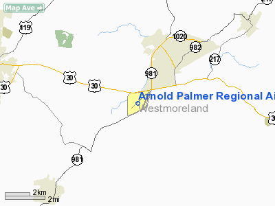
Arnold Palmer Regional Airport (IATA: LBE, ICAO: KLBE, FAA LID: LBE) is a public use airport located two nautical miles (3.7 km) southwest of the central business district of Latrobe, in Westmoreland County, Pennsylvania, United States. It is owned by the Westmoreland County Airport Authority and was formerly known as Westmoreland County Airport. It is primarily used for general aviation. There is no scheduled commercial service available.
The airport was served by one commercial airline, Northwest Airlink, as a reliever for Pittsburgh International Airport on the other side of the Pittsburgh metropolitan area. The airport also had regional service by US Airways to Pittsburgh International Airport, until the company's bankruptcy. Northwest/Delta ended its daily service to Detroit on July 31, 2009 due to low yields, leaving the airport with no commercial service.
The airport is currently attempting to recruit another carrier to re-establish service in order to beat an October 31, 2011 deadline when they will lose a $1M USD federal grant.
Facilities and aircraft
Arnold Palmer Regional Airport covers an area of 945 acres (382 ha) at an elevation of 1,199 feet (365 m) above mean sea level. It has two asphalt paved runways: 5/23 is 8,223 by 100 feet (2,506 x 30 m) and 3/21 is 3,613 by 75 feet (1,101 x 23 m).
For the 12-month period ending October 31, 2009, the airport had 28,469 aircraft operations, an average of 77 per day: 75% general aviation, 17% scheduled commercial, and 8% military. At that time there were 148 aircraft based at this airport: 42% single-engine, 38% multi-engine, 15% jet and 5% helicopter.
The airport features one terminal building with one baggage claim. All parking at the airport is free. Fixed base operators (FBOs) on the field include L.J. Aviation and Vee Neal Aviation.
The above content comes from Wikipedia and is published under free licenses – click here to read more.
Location & QuickFacts
| FAA Information Effective: | 2008-09-25 |
| Airport Identifier: | LBE |
| Airport Status: | Operational |
| Longitude/Latitude: | 079-24-24.3000W/40-16-28.6000N
-79.406750/40.274611 (Estimated) |
| Elevation: | 1199 ft / 365.46 m (Estimated) |
| Land: | 945 acres |
| From nearest city: | 2 nautical miles SW of Latrobe, PA |
| Location: | Westmoreland County, PA |
| Magnetic Variation: | 07W (1980) |
Owner & Manager
| Ownership: | Publicly owned |
| Owner: | Westmoreland County Arpt Auth |
| Address: | 148 Aviation Lane, Suite 103
Latrobe, PA 15650-9549 |
| Phone number: | 724-640-7234 |
| Manager: | Gabe Monzo |
| Address: | 148 Aviation Lane, Suite 103
Latrobe, PA 15650-9549 |
| Phone number: | 724-539-8100 |
Airport Operations and Facilities
| Airport Use: | Open to public |
| Wind indicator: | Yes |
| Control Tower: | Yes |
| Lighting Schedule: | DUSK-DAWN
WHEN ATCT CLSD; ACTVT HIRL RY 05/23, PAPI RY 05/23, REIL RY 05 & MALSF RY 23, TWY A, B, C & D - CTAF. MIRL RY 03/21, TWY F, G, H & TWY B WEST OF RY 03/21 UNAVBLE WHEN ATCT CLSD. |
| Beacon Color: | Clear-Green (lighted land airport) |
| Landing fee charge: | Yes |
| Sectional chart: | Detroit |
| Region: | AEA - Eastern |
| Boundary ARTCC: | ZOB - Cleveland |
| Tie-in FSS: | AOO - Altoona |
| FSS on Airport: | No |
| FSS Toll Free: | 1-800-WX-BRIEF |
| NOTAMs Facility: | LBE (NOTAM-d service avaliable) |
| Certification type/date: | I A S 04/1977
PPR 24 HRS FOR ACR OPNS WITH MORE THAN 30 PSGR SEATS CALL AMGR 724-539-8100. |
| Federal Agreements: | NGVY |
Airport Communications
Airport Services
| Fuel available: | 100LLA |
| Airframe Repair: | MAJOR |
| Power Plant Repair: | MAJOR |
| Bottled Oxygen: | HIGH |
| Bulk Oxygen: | NONE |
Runway Information
Runway 03/21
| Dimension: | 3609 x 75 ft / 1100.0 x 22.9 m |
| Surface: | ASPH, Good Condition |
| Weight Limit: | Single wheel: 22000 lbs. |
| Edge Lights: | Medium |
| |
Runway 03 |
Runway 21 |
| Longitude: | 079-24-02.8533W | 079-23-47.1366W |
| Latitude: | 40-16-24.1895N | 40-16-57.7566N |
| Elevation: | 1141.00 ft | 1141.00 ft |
| Alignment: | 20 | 127 |
| Traffic Pattern: | Left | Left |
| Markings: | Nonstandard, Good Condition
NSTD RY 3 THLD BAR FADED; LCTD ON BLAST PAD & NOT IN PROPER LOCATION; BLAST PAD CHEVRONS ARE INCOMPLETE. | Non-precision instrument, Good Condition |
| Obstruction: | 52 ft pole, 1085.0 ft from runway, 208 ft right of centerline, 17:1 slope to clear | , 50:1 slope to clear |
| Decleard distances: | Take off run available 3609.00 ft
Take off distance available 3609.00 ft
Actual stop distance available 3609.00 ft
Landing distance available 3609.00 ft
| Take off run available 3609.00 ft
Take off distance available 3609.00 ft
Actual stop distance available 3609.00 ft
Landing distance available 3609.00 ft
|
|
Runway 05/23
| Dimension: | 8223 x 100 ft / 2506.4 x 30.5 m |
| Surface: | ASPH, Good Condition |
| Surface Treatment: | Saw-cut or plastic Grooved |
| Weight Limit: | Single wheel: 68000 lbs.
Dual wheel: 90000 lbs.
Dual tandem wheel: 150000 lbs. |
| Edge Lights: | High |
| |
Runway 05 |
Runway 23 |
| Longitude: | 079-25-15.1773W | 079-23-59.1664W |
| Latitude: | 40-15-54.8269N | 40-16-51.4959N |
| Elevation: | 1199.00 ft | 1145.00 ft |
| Alignment: | 46 | 127 |
| ILS Type: | | ILS
|
| Traffic Pattern: | Left | Right |
| Markings: | Non-precision instrument, Good Condition | Precision instrument, Good Condition |
| Crossing Height: | 34.00 ft | 55.00 ft |
| Displaced threshold: | 0.00 ft | 850.00 ft |
| VASI: | 4-light PAPI on left side | 4-light PAPI on left side |
| Visual Glide Angle: | 3.00° | 3.00° |
| Approach lights: | | MALSF |
| Runway End Identifier: | Yes | |
| Obstruction: | 105 ft trees, 2181.0 ft from runway, 760 ft left of centerline, 18:1 slope to clear | , 50:1 slope to clear |
| Decleard distances: | Take off run available 8223.00 ft
Take off distance available 8223.00 ft
Actual stop distance available 8223.00 ft
Landing distance available 8223.00 ft
| Take off run available 8223.00 ft
Take off distance available 8223.00 ft
Actual stop distance available 8223.00 ft
Landing distance available 7373.00 ft
|
|
Radio Navigation Aids
| ID |
Type |
Name |
Ch |
Freq |
Var |
Dist |
| BHU | NDB | Benje | | 382.00 | 07W | 8.7 nm |
| MKP | NDB | Mc Keesport | | 287.00 | 07W | 17.8 nm |
| SYS | NDB | Stoystown | | 209.00 | 08W | 25.2 nm |
| INP | NDB | Indiana | | 242.00 | 08W | 26.5 nm |
| VV | NDB | Camor | | 299.00 | 08W | 28.2 nm |
| PNU | NDB | Washington County | | 255.00 | 08W | 35.6 nm |
| CBE | NDB | Cumberland | | 317.00 | 07W | 48.4 nm |
| AGC | VOR/DME | Allegheny | 037X | 110.00 | 09W | 29.1 nm |
| REC | VOR/DME | Revloc | 043X | 110.60 | 09W | 34.3 nm |
| GRV | VOR/DME | Grantsville | 070X | 112.30 | 06W | 41.8 nm |
| IHD | VORTAC | Indian Head | 019X | 108.20 | 06W | 18.2 nm |
| JST | VORTAC | Johnstown | 077X | 113.00 | 06W | 26.4 nm |
| MMJ | VORTAC | Montour | 057X | 112.00 | 08W | 38.3 nm |
| MGW | VORTAC | Morgantown | 053X | 111.60 | 05W | 48.0 nm |
| EWC | VORTAC | Ellwood City | 105X | 115.80 | 08W | 49.5 nm |
Remarks
- DEER & BIRDS ON & INVOF ARPT.
- TWY J RSTD TO ACFT WITH A WINGSPAN LESS THAN 49 FT.
Images and information placed above are from
http://www.airport-data.com/airport/LBE/
We thank them for the data!
| General Info
|
| Country |
United States
|
| State |
PENNSYLVANIA
|
| FAA ID |
LBE
|
| Latitude |
40-16-33.384N
|
| Longitude |
079-24-17.270W
|
| Elevation |
1185 feet
|
| Near City |
LATROBE
|
We don't guarantee the information is fresh and accurate. The data may
be wrong or outdated.
For more up-to-date information please refer to other sources.
|
|


