 |
|
| Valley View Airport |
 |
| IATA: none – ICAO: none – FAA LID: 5S9 |
| Summary |
| Airport type |
Public |
| Operator |
Private Owner |
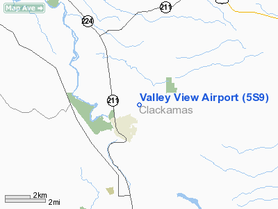
| Location |
Estacada, Oregon |
| Elevation AMSL |
735 ft / 224 m |
| Coordinates |
45°18′29.4350″N 122°19′07.3070″W / 45.30817639°N 122.31869639°W / 45.30817639; -122.31869639Coordinates: 45°18′29.4350″N 122°19′07.3070″W / 45.30817639°N 122.31869639°W / 45.30817639; -122.31869639 |
| Runways |
| Direction |
Length |
Surface |
| ft |
m |
| 16/34 |
3780 |
1152 |
asphalt |
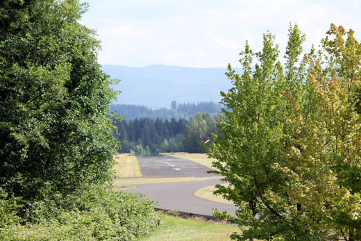
Valley View Airport (FAA LID: 5S9), is a public airport located 1 mile (1.6 km) northeast of Estacada in Clackamas County, Oregon, United States.
The above content comes from Wikipedia and is published under free licenses – click here to read more.
Location & QuickFacts
| FAA Information Effective: | 2008-09-25 |
| Airport Identifier: | 5S9 |
| Airport Status: | Operational |
| Longitude/Latitude: | 122-19-07.3070W/45-18-29.4350N
-122.318696/45.308176 (Estimated) |
| Elevation: | 735 ft / 224.03 m (Estimated) |
| Land: | 134 acres |
| From nearest city: | 1 nautical miles NE of Estacada, OR |
| Location: | Clackamas County, OR |
| Magnetic Variation: | 19E (1985) |
Owner & Manager
| Ownership: | Privately owned |
| Owner: | Bob Veley, Jr |
| Address: | 33700 S.e. Duus Road
Estacada, OR 97023 |
| Phone number: | 312-953-9055 |
| Manager: | Bob Veley, Jr |
| Address: | 33700 S.e. Duus Road
Estacada, OR 97023 |
| Phone number: | 312-953-9055 |
Airport Operations and Facilities
| Airport Use: | Open to public |
| Wind indicator: | Yes |
| Segmented Circle: | No |
| Control Tower: | No |
| Lighting Schedule: | PHONE REQ
LIRL RY 16/34 OWNER'S USE ONLY. |
| Landing fee charge: | No |
| Sectional chart: | Seattle |
| Region: | ANM - Northwest Mountain |
| Traffic Pattern Alt: | 950 ft |
| Boundary ARTCC: | ZSE - Seattle |
| Tie-in FSS: | MMV - Mc Minnville |
| FSS on Airport: | No |
| FSS Toll Free: | 1-800-WX-BRIEF |
| NOTAMs Facility: | MMV (NOTAM-d service avaliable) |
Airport Communications
Airport Services
| Bottled Oxygen: | NONE |
| Bulk Oxygen: | NONE |
Runway Information
Runway 16/34
| Dimension: | 3780 x 32 ft / 1152.1 x 9.8 m |
| Surface: | ASPH, Good Condition |
| Edge Lights: | Non-standard lighting system
NSTD LIRL - INNER 2240 FT LIGHTED. |
| |
Runway 16 |
Runway 34 |
| Traffic Pattern: | Left | Left |
| Markings: | Numbers only, Good Condition | Numbers only, Good Condition |
| Displaced threshold: | 490.00 ft | 0.00 ft |
| Obstruction: | 50 ft trees, 260.0 ft from runway, 60 ft left of centerline, 1:1 slope to clear
RWY 16 +100 FT TREES, DIST 1,000 FT, 100 FT L, 11:1 BASED ON DSPLCD THLD.
+35 FT TREES, 150 FT FM RY END, 50 FT R. | 30 ft trees, 430.0 ft from runway, 75 ft right of centerline, 7:1 slope to clear |
|
Radio Navigation Aids
| ID |
Type |
Name |
Ch |
Freq |
Var |
Dist |
| LBH | NDB | Laker | | 332.00 | 20E | 15.3 nm |
| PND | NDB | Banks | | 356.00 | 21E | 36.3 nm |
| CBU | TACAN | Columbia | 029X | | 20E | 20.9 nm |
| PDX | VOR/DME | Portland | 055X | 111.80 | 20E | 21.0 nm |
| UBG | VOR/DME | Newberg | 121X | 117.40 | 21E | 28.0 nm |
| BTG | VORTAC | Battle Ground | 113X | 116.60 | 21E | 28.8 nm |
| PDX | VOT | Portland Intl | | 111.00 | | 21.1 nm |
| HIO | VOT | Portland-hillsboro | | 115.20 | | 30.0 nm |
Images and information placed above are from
http://www.airport-data.com/airport/5S9/
We thank them for the data!
| General Info
|
| Country |
United States
|
| State |
OREGON
|
| FAA ID |
5S9
|
| Latitude |
45-18-29.435N
|
| Longitude |
122-19-07.307W
|
| Elevation |
735 feet
|
| Near City |
ESTACADA
|
We don't guarantee the information is fresh and accurate. The data may
be wrong or outdated.
For more up-to-date information please refer to other sources.
|
|


