 |
|
Rogue Valley Intl - Medford Airport |
| Rogue Valley International - Medford Airport |
 |
| IATA: MFR – ICAO: KMFR |
| Summary |
| Airport type |
Public |
| Operator |
Jackson County |
| Location |
Medford, Oregon |
| Elevation AMSL |
1,335 ft / 406.9 m |
| Coordinates |
42°22′27.2″N 122°52′24.6″W / 42.374222°N 122.8735°W / 42.374222; -122.8735Coordinates: 42°22′27.2″N 122°52′24.6″W / 42.374222°N 122.8735°W / 42.374222; -122.8735 |
| Runways |
| Direction |
Length |
Surface |
| ft |
m |
| 14/32 |
8,800 |
2,682 |
Asphalt |
| 9/27 |
3,136 |
956 |
Asphalt |
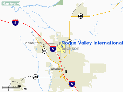
Rogue Valley International-Medford Airport (IATA: MFR, ICAO: KMFR) is a public airport located 3 miles (5 km) north of downtown Medford in Jackson County, Oregon, USA. In addition to Jackson County, the airport serves seven nearby counties in southwest Oregon. It is owned and operated by Jackson County's Aviation Authority. The Medford Airport is the third busiest airport in Oregon . Facilities
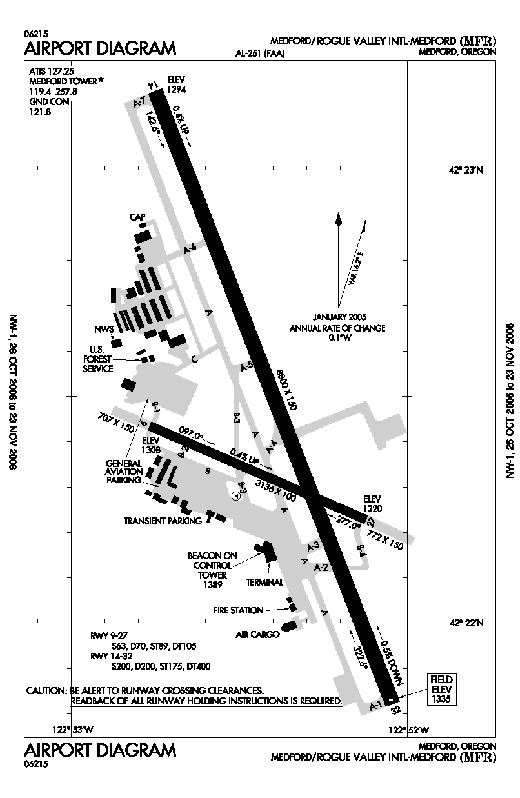
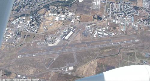
Rogue Valley International-Medford Airport covers 989 acres (400 ha) and has two runways.
The airport has recently undergone major renovations which include a new 110,000 sq ft (10,000 m) terminal building with room for expansion. The new terminal hosts an observation deck on the second floor, as well as a restaurant for screened and unscreened passengers. Also, second-story loading bridges have been put in place for easier loading and unloading of passengers. Now that the new terminal is complete, there is a main concourse, and two open air concourses. Coincided with the construction of a new terminal, a new control tower was built as well. The new $3.6 million, 100-foot-tall (30 m) control tower uses a state-of-the-art geothermal system to heat and cool the building. The tower was completed in late 2008.
Three fixed-based operators (FBOs) currently provide general aviation services on the field: Medford Air Service, Jet Center MFR, and Million Air (which recently completed its new three-story corporate terminal). Horizon Air recently increased the number of CRJ700 passenger jets serving Rogue Valley International-Medford Airport, with non-stop flights to Portland (PDX) and Seattle/Tacoma (SEA). Effective March 2009, Horizon Air added a second non-stop flight to and from Los Angeles (LAX). Non-stop service to Denver (DEN) and San Francisco (SFO), serviced by United Express, has also increased its passenger capacity utilizing CRJ700's as well. Allegiant Air, which services Las Vegas and Phoenix-Mesa, announced February 18, 2009 that they will add a third destination to the Rogue Valley-Medford International Airport. Beginning May 1, 2009, Allegiant Air will offer low-cost non-stop flights to Los Angeles. The Rogue Valley International-Medford Airport was one of 12 airports to receive this service.
Airlines and destinations
| Airlines |
Destinations |
| Allegiant Air |
Las Vegas, Los Angeles, Phoenix/Mesa |
| Delta Connection operated by SkyWest Airlines |
Salt Lake City |
| Horizon Air |
Los Angeles, Portland (OR), Seattle/Tacoma |
| United Express operated by SkyWest Airlines |
Denver, Portland (OR), San Francisco |
Incidents
On January 7, 2008 a US Airways Express jet arriving from Las Vegas struck a coyote, killing it.
The above content comes from Wikipedia and is published under free licenses – click here to read more.
 |
(Click on the photo to enlarge) |
Location & QuickFacts
| FAA Information Effective: | 2008-09-25 |
| Airport Identifier: | MFR |
| Airport Status: | Operational |
| Longitude/Latitude: | 122-52-24.6000W/42-22-27.2000N
-122.873500/42.374222 (Estimated) |
| Elevation: | 1335 ft / 406.91 m (Surveyed) |
| Land: | 989 acres |
| From nearest city: | 3 nautical miles N of Medford, OR |
| Location: | Jackson County, OR |
| Magnetic Variation: | 19E (1980) |
Owner & Manager
| Ownership: | Publicly owned |
| Owner: | Jackson County |
| Address: | Co Court House; 10 So Oakdale
Medford, OR 97501 |
| Phone number: | 541-774-6035 |
| Manager: | Bern E. Case |
| Address: | 3650 Biddle Road 13
Medford, OR 97504 |
| Phone number: | 541-776-7222
FAX 541-776-7223 |
Airport Operations and Facilities
| Airport Use: | Open to public |
| Wind indicator: | Yes |
| Segmented Circle: | Yes |
| Control Tower: | Yes |
| Lighting Schedule: | DUSK-DAWN
ACTV HIRL RY 14/32, MALSR RY 14, REIL 32, TDZL RY 14 CENTERLINE LGTS 14/32 AND TWY LGTS - CTAF. |
| Beacon Color: | Clear-Green (lighted land airport) |
| Landing fee charge: | No |
| Sectional chart: | Klamath Falls |
| Region: | ANM - Northwest Mountain |
| Traffic Pattern Alt: | 969 ft |
| Boundary ARTCC: | ZSE - Seattle |
| Tie-in FSS: | MMV - Mc Minnville |
| FSS on Airport: | No |
| FSS Toll Free: | 1-800-WX-BRIEF |
| NOTAMs Facility: | MFR (NOTAM-d service avaliable) |
| Certification type/date: | I B S 05/1973
PPR FOR UNSKED OPNS WITH MORE THAN 30 PSGR SEATS CALL AIRPORT OPERATIONS 541-776-7228. |
| Federal Agreements: | NGPY |
Airport Communications
| CTAF: | 119.400 |
| Unicom: | 122.950 |
Airport Services
| Fuel available: | 100 100LL80 A1+
FOR FUEL 2100-0430 CALL 541-770-5314 OR 541-779-5451. |
| Airframe Repair: | MAJOR |
| Power Plant Repair: | MAJOR |
| Bottled Oxygen: | HIGH |
| Bulk Oxygen: | HIGH |
Runway Information
Runway 09/27
| Dimension: | 3136 x 100 ft / 955.9 x 30.5 m |
| Surface: | ASPH, Good Condition |
| Weight Limit: | Single wheel: 63000 lbs.
Dual wheel: 70000 lbs.
Dual tandem wheel: 105000 lbs. |
| Edge Lights: | Medium
RY 09/27 NSTD MIRL FIRST 10 FT OF RY 09 UNLGT AND FIRST 9 FT OF RY 27 UNLGT, 3136 FT LGTD. |
| |
Runway 09 |
Runway 27 |
| Longitude: | 122-52-45.8943W | 122-52-07.5231W |
| Latitude: | 42-22-25.9645N | 42-22-13.7297N |
| Elevation: | 1308.00 ft | 1320.00 ft |
| Alignment: | 113 | 127 |
| Traffic Pattern: | Left | Left |
| Markings: | Basic, Good Condition | Basic, Good Condition |
|
Runway 14/32
| Dimension: | 8800 x 150 ft / 2682.2 x 45.7 m |
| Surface: | ASPH, |
| Surface Treatment: | Saw-cut or plastic Grooved |
| Weight Limit: | Single wheel: 200000 lbs.
Dual wheel: 200000 lbs.
Dual tandem wheel: 400000 lbs. |
| Edge Lights: | High
RY 09/27 NSTD MIRL FIRST 10 FT OF RY 09 UNLGT AND FIRST 9 FT OF RY 27 UNLGT, 3136 FT LGTD. |
| |
Runway 14 |
Runway 32 |
| Longitude: | 122-52-45.0675W | 122-52-02.6097W |
| Latitude: | 42-23-10.3796N | 42-21-49.3551N |
| Elevation: | 1294.00 ft | 1335.00 ft |
| Alignment: | 127 | 127 |
| ILS Type: | ILS/DME
| |
| Traffic Pattern: | Left | Left |
| Markings: | Precision instrument, Good Condition | Non-precision instrument, Good Condition |
| Crossing Height: | 73.00 ft | 49.00 ft |
| VASI: | 4-light PAPI on left side | 4-box on left side |
| Visual Glide Angle: | 3.00° | 3.00° |
| RVR Equipment: | touchdown | |
| Approach lights: | MALSR | |
| Runway End Identifier: | | Yes |
| Centerline Lights: | Yes | Yes |
| Touchdown Lights: | Yes | |
|
Radio Navigation Aids
| ID |
Type |
Name |
Ch |
Freq |
Var |
Dist |
| MEF | NDB | Medford | | 356.00 | 19E | 1.1 nm |
| MOG | NDB | Montague | | 404.00 | 19E | 42.6 nm |
| OED | VORTAC | Rogue Valley | 083X | 113.60 | 19E | 6.6 nm |
| MFR | VOT | Medford-jackson County | | 117.20 | | 1.0 nm |
Remarks
- BIRD HAZARD LARGE FLOCKS OF MIGRATORY WATERFOWL IN VICINITY NOV-MAY.
- ATCT SVCS NOT AVBL ON TWY B-1 ON THE NW SIDE OF AER 9 ON TWY C BTN THE ACCESS ROAD W OF TWY A & MEDFORD AIR RAMP DUE TO MOVEMENT OF UNCONTROLLED GROUND TRAFFIC.
- ATCT SVCS NOT AVBL ON TWY B/B-1 S OF AER 9.
- RY 09/27 CLSD TO ACFT OVER 12,500 LBS GWT.
Images and information placed above are from
http://www.airport-data.com/airport/MFR/
We thank them for the data!
| General Info
|
| Country |
United States
|
| State |
OREGON
|
| FAA ID |
MFR
|
| Latitude |
42-22-27.220N
|
| Longitude |
122-52-24.592W
|
| Elevation |
1335 feet
|
| Near City |
MEDFORD
|
We don't guarantee the information is fresh and accurate. The data may
be wrong or outdated.
For more up-to-date information please refer to other sources.
|
|


