 |
|
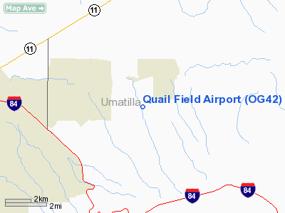
Location & QuickFacts
| FAA Information Effective: | 2008-09-25 |
| Airport Identifier: | OG42 |
| Airport Status: | Operational |
| Longitude/Latitude: | 118-35-22.9000W/45-39-17.4700N
-118.589694/45.654853 (Estimated) |
| Elevation: | 1610 ft / 490.73 m (Estimated) |
| Land: | 15 acres |
| From nearest city: | 9 nautical miles E of Pendleton, OR |
| Location: | Umatilla County, OR |
| Magnetic Variation: | () |
Owner & Manager
| Ownership: | Privately owned |
| Owner: | Leonard & Janna Quaile |
| Address: | 73004 Fowler Lane
Pendleton, OR 97801 |
| Phone number: | 541-966-6272 |
| Manager: | Leonard & Janna Quaile |
| Address: | 73004 Fowler Lane
Pendleton, OR 97801 |
| Phone number: | 541-966-6272 |
Airport Operations and Facilities
| Airport Use: | Private |
| Wind indicator: | Yes |
| Segmented Circle: | No |
| Control Tower: | No |
| Sectional chart: | Seattle |
| Region: | ANM - Northwest Mountain |
| Boundary ARTCC: | ZSE - Seattle |
| Tie-in FSS: | MMV - Mc Minnville |
| FSS Toll Free: | 1-800-WX-BRIEF |
Runway Information
Runway 16/34
| Dimension: | 1335 x 30 ft / 406.9 x 9.1 m |
| Surface: | TURF, |
| |
Runway 16 |
Runway 34 |
| Traffic Pattern: | Left | Left |
| Obstruction: | | 15 ft trees, 250.0 ft from runway |
|
Radio Navigation Aids
| ID |
Type |
Name |
Ch |
Freq |
Var |
Dist |
| PD | NDB | Foris | | 230.00 | 20E | 6.4 nm |
| LGD | NDB | La Grande | | 296.00 | 17E | 32.4 nm |
| ALW | VOR/DME | Walla Walla | 111X | 116.40 | 20E | 28.8 nm |
| PSC | VOR/DME | Pasco | 021X | 108.40 | 20E | 42.7 nm |
| PDT | VORTAC | Pendleton | 094X | 114.70 | 20E | 14.9 nm |
Remarks
- BIRDS AND DEER ON & INVOF ARPT.
Images and information placed above are from
http://www.airport-data.com/airport/OG42/
We thank them for the data!
|
|


