 |
|
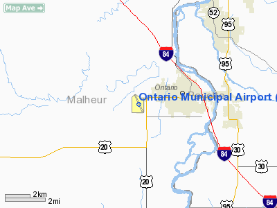
| Ontario Municipal Airport |
| IATA: ONO – ICAO: KONO |
| Summary |
| Airport type |
Public |
| Operator |
City of Ontario |
| Location |
Ontario, Oregon |
| Elevation AMSL |
2193 ft / 668.4 m |
| Coordinates |
44°01′13.8870″N 117°00′49.0860″W / 44.02052417°N 117.013635°W / 44.02052417; -117.013635Coordinates: 44°01′13.8870″N 117°00′49.0860″W / 44.02052417°N 117.013635°W / 44.02052417; -117.013635 |
| Runways |
| Direction |
Length |
Surface |
| ft |
m |
| 14/32 |
4307 |
1313 |
Asphalt |
Ontario Municipal Airport (IATA: ONO, ICAO: KONO), is a public airport located three miles (4.8 km) west of the city of Ontario in Malheur County, Oregon, USA.
The above content comes from Wikipedia and is published under free licenses – click here to read more.
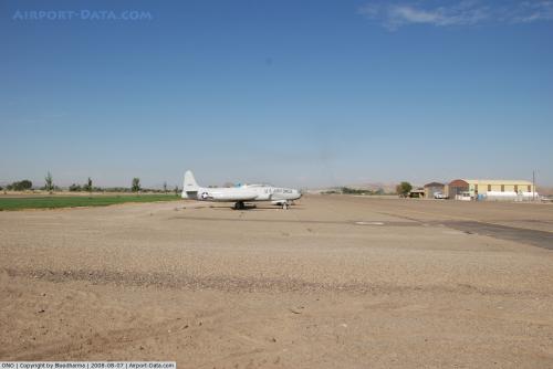 |
(Click on the photo to enlarge) |
Location & QuickFacts
| FAA Information Effective: | 2008-09-25 |
| Airport Identifier: | ONO |
| Airport Status: | Operational |
| Longitude/Latitude: | 117-00-46.9000W/44-01-09.7000N
-117.013028/44.019361 (Estimated) |
| Elevation: | 2193 ft / 668.43 m (Surveyed) |
| Land: | 480 acres |
| From nearest city: | 3 nautical miles W of Ontario, OR |
| Location: | Malheur County, OR |
| Magnetic Variation: | 17E (1985) |
Owner & Manager
| Ownership: | Publicly owned |
| Owner: | City Of Ontario |
| Address: | 444 Sw 4th St
Ontario, OR 97914 |
| Phone number: | 541-889-7684 |
| Manager: | Alan Daniels |
| Address: | 581 Sw 33rd St.
Ontario, OR 97914 |
| Phone number: | 541-881-8848
OR 541-212-1676 CELL. |
Airport Operations and Facilities
| Airport Use: | Open to public |
| Wind indicator: | Yes |
| Segmented Circle: | Yes |
| Control Tower: | No |
| Lighting Schedule: | DUSK-DAWN
ACTVT MIRL RY 14/32 AND REIL RY 32 - CTAF. PAPI RY 32 OPER CONT. |
| Beacon Color: | Clear-Green (lighted land airport) |
| Landing fee charge: | No |
| Sectional chart: | Klamath Falls |
| Region: | ANM - Northwest Mountain |
| Boundary ARTCC: | ZLC - Salt Lake City |
| Tie-in FSS: | MMV - Mc Minnville |
| FSS on Airport: | No |
| FSS Toll Free: | 1-800-WX-BRIEF |
| NOTAMs Facility: | ONO (NOTAM-d service avaliable) |
| Federal Agreements: | NGPY3 |
Airport Communications
| CTAF: | 122.800 |
| Unicom: | 122.800 |
Airport Services
| Fuel available: | 100LLA
SELF SERVE CARD LOCK FUEL AVAIL. 24 HRS. |
| Airframe Repair: | MAJOR |
| Power Plant Repair: | MAJOR |
| Bottled Oxygen: | NONE |
Runway Information
Runway 14/32
| Dimension: | 5011 x 100 ft / 1527.4 x 30.5 m |
| Surface: | ASPH, Fair Condition |
| Weight Limit: | Single wheel: 30000 lbs.
Dual wheel: 50000 lbs. |
| Edge Lights: | Medium |
| |
Runway 14 |
Runway 32 |
| Longitude: | 117-00-59.3851W | 117-00-34.3511W |
| Latitude: | 44-01-32.7315N | 44-00-46.6578N |
| Elevation: | 2193.00 ft | 2188.00 ft |
| Alignment: | 127 | 127 |
| Traffic Pattern: | Left | Left |
| Markings: | Non-precision instrument, Good Condition | Non-precision instrument, Good Condition |
| VASI: | | 2-light PAPI on left side |
| Runway End Identifier: | | Yes |
| Centerline Lights: | | No |
| Touchdown Lights: | | No |
| Obstruction: | 10 ft road, 201.0 ft from runway, 183 ft right of centerline
RWY 14 8 FT ROAD 320 FT 200 FT L; 40:1 BASED ON DSPLCD THLD.
RWY 14 +8 FT ROAD, 100 FT FROM RWY END, 200 FT R. | 2 ft berm, 285.0 ft from runway, 42:1 slope to clear |
|
Radio Navigation Aids
| ID |
Type |
Name |
Ch |
Freq |
Var |
Dist |
| ONO | NDB | Ontario | | 305.00 | 17E | 0.2 nm |
| MPA | NDB | Meridian | | 238.00 | 16E | 32.4 nm |
| BO | NDB | Ustik | | 359.00 | 17E | 39.5 nm |
| BOI | VORTAC | Boise | 080X | 113.30 | 17E | 45.3 nm |
| BOI | VOT | Boise | | 116.70 | | 43.4 nm |
Remarks
- TAXIWAY MARKED WITH BLUE REFLECTORS
- RY 14/32 EXTDD SOUTH END.
- ESTABD PRIOR TO 15 MAY 1959.
Images and information placed above are from
http://www.airport-data.com/airport/ONO/
We thank them for the data!
| General Info
|
| Country |
United States
|
| State |
OREGON
|
| FAA ID |
ONO
|
| Latitude |
44-01-13.887N
|
| Longitude |
117-00-49.086W
|
| Elevation |
2193 feet
|
| Near City |
ONTARIO
|
We don't guarantee the information is fresh and accurate. The data may
be wrong or outdated.
For more up-to-date information please refer to other sources.
|
|


