 |
|
| Oakridge State Airport |
| IATA: none – ICAO: none – FAA LID: 5S0 |
| Summary |
| Airport type |
Public |
| Operator |
Oregon Department of Aviation |
| Location |
Oakridge, Oregon |
| Elevation AMSL |
1393 ft / 425 m |
| Coordinates |
43°45′09.4440″N 122°30′09.1850″W / 43.75262333°N 122.50255139°W / 43.75262333; -122.50255139Coordinates: 43°45′09.4440″N 122°30′09.1850″W / 43.75262333°N 122.50255139°W / 43.75262333; -122.50255139 |
| Runways |
| Direction |
Length |
Surface |
| ft |
m |
| 9/27 |
3610 |
1100 |
Asphalt |
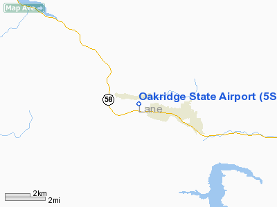
Oakridge State Airport (FAA LID: 5S0), is a public airport located 1 mile (1.6 km) west of Oakridge, in Lane County, Oregon, USA.
The above content comes from Wikipedia and is published under free licenses – click here to read more.
Location & QuickFacts
| FAA Information Effective: | 2008-09-25 |
| Airport Identifier: | 5S0 |
| Airport Status: | Operational |
| Longitude/Latitude: | 122-30-09.1850W/43-45-09.4440N
-122.502551/43.752623 (Estimated) |
| Elevation: | 1393 ft / 424.59 m (Estimated) |
| Land: | 39 acres |
| From nearest city: | 1 nautical miles W of Oakridge, OR |
| Location: | Lane County, OR |
| Magnetic Variation: | 19E (1985) |
Owner & Manager
| Ownership: | Publicly owned |
| Owner: | Oregon Department Of Aviation |
| Address: | 3040 25th St, Se
Salem, OR 97310 |
| Phone number: | 503-378-4880 |
| Manager: | State Airports Mgr. |
| Address: | 3040 25th St, Se
Salem, OR 97310 |
| Phone number: | 503-378-4880 |
Airport Operations and Facilities
| Airport Use: | Open to public |
| Wind indicator: | Yes |
| Segmented Circle: | No |
| Control Tower: | No |
| Landing fee charge: | No |
| Sectional chart: | Klamath Falls |
| Region: | ANM - Northwest Mountain |
| Traffic Pattern Alt: | 1000 ft |
| Boundary ARTCC: | ZSE - Seattle |
| Tie-in FSS: | MMV - Mc Minnville |
| FSS on Airport: | No |
| FSS Toll Free: | 1-800-WX-BRIEF |
| NOTAMs Facility: | MMV (NOTAM-d service avaliable) |
Airport Communications
Airport Services
| Bottled Oxygen: | NONE |
| Bulk Oxygen: | NONE |
Runway Information
Runway 09/27
| Dimension: | 3610 x 47 ft / 1100.3 x 14.3 m |
| Surface: | ASPH, Fair Condition |
| |
Runway 09 |
Runway 27 |
| Traffic Pattern: | Left | Left |
| Markings: | Basic, Good Condition | Basic, Good Condition |
| Obstruction: | 52 ft trees, 525.0 ft from runway, 65L/ ft right of centerline, 6:1 slope to clear
RWY 09 +24 FT TREES; 70FT FM RY END 72 FT RIGHT. | 28 ft road, 390.0 ft from runway, 6:1 slope to clear
TERRAIN RISES SMOOTHLY AT 14:1 FM RY END TO +14 FT AT 200 FT FM RY & CONTINUES TO RISE TO +65 FT AT 920 FT FM RY END ON CNTRLN. |
|
Radio Navigation Aids
| ID |
Type |
Name |
Ch |
Freq |
Var |
Dist |
| EU | NDB | Frakk | | 260.00 | 19E | 41.6 nm |
| RBG | NDB | Roseburg | | 400.00 | 20E | 48.6 nm |
| EUG | VORTAC | Eugene | 076X | 112.90 | 20E | 38.2 nm |
Remarks
- USFS HELICOPTERS ACTIVE INVOF ARPT DURING FIRE SEASON.
- DEER AND ELK ON AND INVOF ARPT.
- IRREGULAR WINTER MAINTENANCE; ARPT MAY BE CLOSED BY SNOW.
Images and information placed above are from
http://www.airport-data.com/airport/5S0/
We thank them for the data!
| General Info
|
| Country |
United States
|
| State |
OREGON
|
| FAA ID |
5S0
|
| Latitude |
43-45-09.444N
|
| Longitude |
122-30-09.185W
|
| Elevation |
1393 feet
|
| Near City |
OAKRIDGE
|
We don't guarantee the information is fresh and accurate. The data may
be wrong or outdated.
For more up-to-date information please refer to other sources.
|
|


