 |
|
Miller Memorial Airpark Airport |
| Miller Memorial Airpark |
| IATA: none – ICAO: none – FAA LID: S49 |
| Summary |
| Airport type |
Public |
| Operator |
City of Vale |
| Location |
Vale, Oregon |
| Elevation AMSL |
2249 ft / 685 m |
| Coordinates |
43°57′49.5780″N 117°15′33.6330″W / 43.96377167°N 117.2593425°W / 43.96377167; -117.2593425Coordinates: 43°57′49.5780″N 117°15′33.6330″W / 43.96377167°N 117.2593425°W / 43.96377167; -117.2593425 |
| Runways |
| Direction |
Length |
Surface |
| ft |
m |
| 18/36 |
3872 |
1180 |
Gravel |
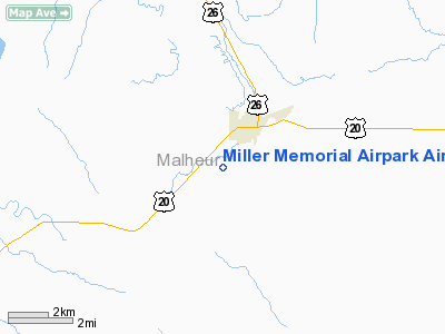
Miller Memorial Airpark (FAA LID: S49) is a public airport located one mile (1.6 km) southwest of Vale in Malheur County, Oregon, USA.
The above content comes from Wikipedia and is published under free licenses – click here to read more.
Location & QuickFacts
| FAA Information Effective: | 2008-09-25 |
| Airport Identifier: | S49 |
| Airport Status: | Operational |
| Longitude/Latitude: | 117-15-33.6330W/43-57-49.5780N
-117.259342/43.963772 (Estimated) |
| Elevation: | 2249 ft / 685.50 m (Surveyed) |
| Land: | 180 acres |
| From nearest city: | 1 nautical miles SW of Vale, OR |
| Location: | Malheur County, OR |
| Magnetic Variation: | 17E (1985) |
Owner & Manager
| Ownership: | Publicly owned |
| Owner: | City Of Vale |
| Address: | 252 'b' St. West
Vale, OR 97918 |
| Phone number: | 541-473-3327 |
| Manager: | Bob Bement |
| Address: | 477 Bryant St.
Vale, OR 97918 |
| Phone number: | 541-473-2530 |
Airport Operations and Facilities
| Airport Use: | Open to public |
| Wind indicator: | Yes |
| Segmented Circle: | Yes |
| Control Tower: | No |
| Lighting Schedule: | DUSK-DAWN
ACTVT LIRL RY 18/36 - CTAF. |
| Beacon Color: | Clear-Green (lighted land airport) |
| Landing fee charge: | No |
| Sectional chart: | Klamath Falls |
| Region: | ANM - Northwest Mountain |
| Boundary ARTCC: | ZLC - Salt Lake City |
| Tie-in FSS: | MMV - Mc Minnville |
| FSS on Airport: | No |
| FSS Toll Free: | 1-800-WX-BRIEF |
| NOTAMs Facility: | MMV (NOTAM-d service avaliable) |
Airport Communications
Airport Services
| Airframe Repair: | NONE |
| Power Plant Repair: | NONE |
| Bottled Oxygen: | NONE |
| Bulk Oxygen: | NONE |
Runway Information
Runway 10/28
| Dimension: | 2100 x 40 ft / 640.1 x 12.2 m |
| Surface: | GRVL, Fair Condition
RY 36 HAS VERY ROUGH GRAVEL EXTENSION. |
| |
Runway 10 |
Runway 28 |
| Traffic Pattern: | Left | Left |
| Obstruction: | 2 ft berm, 20.0 ft from runway, 10:1 slope to clear | 13 ft brush, 10.0 ft from runway, 35L/ ft right of centerline
13' TREES 10' FROM RUNWAY END, BOTH SIDES OF CENTERLINE |
|
Runway 18/36
| Dimension: | 3872 x 65 ft / 1180.2 x 19.8 m |
| Surface: | GRVL, Fair Condition
RY 36 HAS VERY ROUGH GRAVEL EXTENSION. |
| Edge Lights: | Low |
| |
Runway 18 |
Runway 36 |
| Traffic Pattern: | Left | Left |
| Displaced threshold: | 880.00 ft | 125.00 ft |
| Obstruction: | 15 ft road, 120.0 ft from runway, 8:1 slope to clear
RWY 18 APCH SLOPE 50:1 TO DSPLCD THR. | 10 ft brush, 10.0 ft from runway, 1:1 slope to clear
13:1 BASED ON DISPLACED THRESHOLD |
|
Radio Navigation Aids
| ID |
Type |
Name |
Ch |
Freq |
Var |
Dist |
| ONO | NDB | Ontario | | 305.00 | 17E | 11.4 nm |
| MPA | NDB | Meridian | | 238.00 | 16E | 38.0 nm |
| BO | NDB | Ustik | | 359.00 | 17E | 46.5 nm |
Remarks
- SAGE TO 3' IN PRIM SFC ADJACENT TO ALL RWYS.
- ESTABD PRIOR TO 15 MAY 1959.
Images and information placed above are from
http://www.airport-data.com/airport/S49/
We thank them for the data!
| General Info
|
| Country |
United States
|
| State |
OREGON
|
| FAA ID |
S49
|
| Latitude |
43-57-49.578N
|
| Longitude |
117-15-33.633W
|
| Elevation |
2249 feet
|
| Near City |
VALE
|
We don't guarantee the information is fresh and accurate. The data may
be wrong or outdated.
For more up-to-date information please refer to other sources.
|
|


