 |
|
| McNary ARNG Field Heliport |
 |
| IATA: none – ICAO: none – FAA LID: 4OR1 |
| Summary |
| Airport type |
Military |
| Operator |
Oregon National Guard |
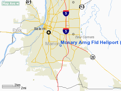
| Location |
Salem, Oregon |
| Elevation AMSL |
209 ft / 64 m |
| Coordinates |
44°54′36″N 123°00′09″W / 44.91°N 123.0025°W / 44.91; -123.0025 |
| Helipads |
| Number |
Length |
Surface |
| ft |
m |
| H1 |
200 x 100 |
61 x 30 |
Asphalt |
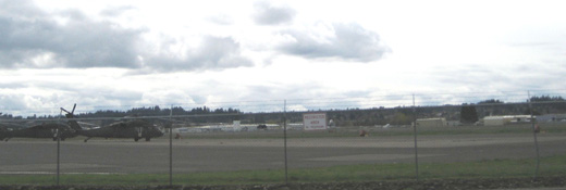
McNary ARNG Field Heliport (FAA LID: 4OR1), is a military heliport located two miles (3 km) southeast of the city of Salem in Marion County, Oregon, USA. The heliport is locate on the north east corner of Salem Municipal Airport (McNary Field). The heliport serves as the primary base of activity for the Oregon National Guard Army Aviation Support Facility.
The above content comes from Wikipedia and is published under free licenses – click here to read more.
Location & QuickFacts
| FAA Information Effective: | 2008-09-25 |
| Airport Identifier: | 4OR1 |
| Airport Status: | Operational |
| Longitude/Latitude: | 123-00-09.3420W/44-54-36.4320N
-123.002595/44.910120 (Estimated) |
| Elevation: | 209 ft / 63.70 m (Estimated) |
| Land: | 0 acres |
| From nearest city: | 2 nautical miles SE of Salem, OR |
| Location: | Marion County, OR |
| Magnetic Variation: | 19E (1985) |
Owner & Manager
| Ownership: | Publicly owned |
| Owner: | Military Dept State Of Or |
| Address: | 1776 Militia Way Box 14350
Salem, OR 97309-5047 |
| Phone number: | 503-378-3993 |
| Manager: | Ronald J Rende
COL IN OREGON ARNG. |
| Address: | 1921 Turner Rd Se
Salem, OR 97302 |
| Phone number: | 503-378-3993 |
Airport Operations and Facilities
| Airport Use: | Private |
| Wind indicator: | Yes |
| Segmented Circle: | No |
| Control Tower: | No |
| Landing fee charge: | No |
| Sectional chart: | Seattle |
| Region: | ANM - Northwest Mountain |
| Boundary ARTCC: | ZSE - Seattle |
| Tie-in FSS: | MMV - Mc Minnville |
| FSS on Airport: | No |
| FSS Toll Free: | 1-800-WX-BRIEF |
Airport Services
| Fuel available: | B+
FUEL FOR MILITARY AIRCRAFT WITH ADVANCE NOTICE. |
| Airframe Repair: | MAJOR |
| Power Plant Repair: | MAJOR |
Runway Information
Helipad H1
| Dimension: | 200 x 100 ft / 61.0 x 30.5 m |
| Surface: | ASPH, |
| |
Runway H1 |
Runway |
| Traffic Pattern: | Left | Left |
|
Radio Navigation Aids
| ID |
Type |
Name |
Ch |
Freq |
Var |
Dist |
| LWG | NDB | Lewisburg | | 225.00 | 18E | 21.2 nm |
| EU | NDB | Frakk | | 260.00 | 19E | 42.9 nm |
| PND | NDB | Banks | | 356.00 | 21E | 43.3 nm |
| LBH | NDB | Laker | | 332.00 | 20E | 44.3 nm |
| CBU | TACAN | Columbia | 029X | | 20E | 44.0 nm |
| UBG | VOR/DME | Newberg | 121X | 117.40 | 21E | 26.7 nm |
| CVO | VOR/DME | Corvallis | 101X | 115.40 | 18E | 27.6 nm |
| PDX | VOR/DME | Portland | 055X | 111.80 | 20E | 44.4 nm |
| EUG | VORTAC | Eugene | 076X | 112.90 | 20E | 48.4 nm |
| ONP | VORTAC | Newport | 118X | 117.10 | 19E | 49.4 nm |
| HIO | VOT | Portland-hillsboro | | 115.20 | | 38.0 nm |
| PDX | VOT | Portland Intl | | 111.00 | | 44.7 nm |
Remarks
- HELIPORT IS OREGON ARMY NATIONAL GUARD OPERATED AND OWNED.
- EMERGENCY REPAIRS TO TRANSIENT MILITARY ACFT ONLY.
Images and information placed above are from
http://www.airport-data.com/airport/4OR1/
We thank them for the data!
| General Info
|
| Country |
United States
|
| State |
OREGON
|
| FAA ID |
4OR1
|
| Latitude |
44-54-36.432N
|
| Longitude |
123-00-09.342W
|
| Elevation |
209 feet
|
| Near City |
SALEM
|
We don't guarantee the information is fresh and accurate. The data may
be wrong or outdated.
For more up-to-date information please refer to other sources.
|
|


