 |
|
| Lenhardt Airpark |
 |
| IATA: none – ICAO: none – FAA LID: 7S9 |
| Summary |
| Airport type |
Public |
| Operator |
Private Owner |
| Location |
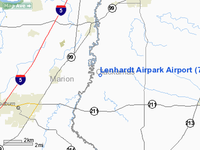
Hubbard, Oregon |
| Elevation AMSL |
165 ft / 50 m |
| Coordinates |
45°10′49.4340″N 122°44′36.3300″W / 45.18039833°N 122.743425°W / 45.18039833; -122.743425Coordinates: 45°10′49.4340″N 122°44′36.3300″W / 45.18039833°N 122.743425°W / 45.18039833; -122.743425 |
| Website |
http://www.infoviva.com/lenhardt/ |
| Runways |
| Direction |
Length |
Surface |
| ft |
m |
| 2/20 |
2956 |
901 |
Asphalt |
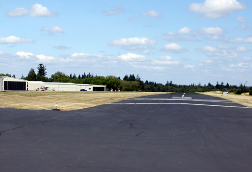
Lenhardt Airpark (FAA LID: 7S9), is a privately owned, public use airport located 3 miles (4.8 km) east of Hubbard in Marion County, Oregon, USA.
The above content comes from Wikipedia and is published under free licenses – click here to read more.
Location & QuickFacts
| FAA Information Effective: | 2008-09-25 |
| Airport Identifier: | 7S9 |
| Airport Status: | Operational |
| Longitude/Latitude: | 122-44-36.3300W/45-10-49.4340N
-122.743425/45.180398 (Estimated) |
| Elevation: | 165 ft / 50.29 m (Estimated) |
| Land: | 30 acres |
| From nearest city: | 3 nautical miles E of Hubbard, OR |
| Location: | Clackamas County, OR |
| Magnetic Variation: | 19E (1985) |
Owner & Manager
| Ownership: | Privately owned |
| Owner: | Jack & Elaine Lenhardt |
| Address: | 29502 S. Meridian Rd
Hubbard, OR 97032 |
| Phone number: | 503-651-2187 |
| Manager: | J Lenhardt |
| Address: | 29502 S Meridian Rd
Hubbard, OR 97032 |
| Phone number: | 503-651-2187 |
Airport Operations and Facilities
| Airport Use: | Open to public |
| Wind indicator: | Yes |
| Segmented Circle: | No |
| Control Tower: | No |
| Lighting Schedule: | DUSK-DAWN |
| Landing fee charge: | No |
| Sectional chart: | Seattle |
| Region: | ANM - Northwest Mountain |
| Boundary ARTCC: | ZSE - Seattle |
| Tie-in FSS: | MMV - Mc Minnville |
| FSS on Airport: | No |
| FSS Toll Free: | 1-800-WX-BRIEF |
| NOTAMs Facility: | MMV (NOTAM-d service avaliable) |
Airport Communications
Airport Services
| Fuel available: | 100LL |
| Airframe Repair: | MAJOR |
| Power Plant Repair: | MAJOR |
| Bottled Oxygen: | NONE |
| Bulk Oxygen: | NONE |
Runway Information
Runway 02/20
| Dimension: | 2956 x 45 ft / 901.0 x 13.7 m |
| Surface: | ASPH, Good Condition |
| Edge Lights: | Low |
| |
Runway 02 |
Runway 20 |
| Longitude: | 122-44-49.1000W | 122-44-22.3000W |
| Latitude: | 45-10-42.4000N | 45-11-04.6000N |
| Traffic Pattern: | Left | Left |
| Markings: | Basic, Good Condition | Basic, Good Condition |
| VASI: | nonstandard system
RY 02 NSTD VASI ONE FLASHING/STEADY LIGHT ON RIGHT SIDE OF RY. | nonstandard system
RY 20 NSTD VASI ONE FLASHING/STEADY LIGHT ON LEFT SIDE OF RY. |
| Visual Glide Angle: | 7.00° | 4.00° |
| Obstruction: | 15 ft road, 230.0 ft from runway, 25 ft left of centerline, 2:1 slope to clear | 80 ft trees, 570.0 ft from runway, 100 ft right of centerline, 4:1 slope to clear
7' TALL TREES @ 60' FROM RUNWAY END AND 30'L |
|
Radio Navigation Aids
| ID |
Type |
Name |
Ch |
Freq |
Var |
Dist |
| LBH | NDB | Laker | | 332.00 | 20E | 24.7 nm |
| PND | NDB | Banks | | 356.00 | 21E | 29.9 nm |
| LWG | NDB | Lewisburg | | 225.00 | 18E | 40.8 nm |
| CBU | TACAN | Columbia | 029X | | 20E | 25.2 nm |
| UBG | VOR/DME | Newberg | 121X | 117.40 | 21E | 14.4 nm |
| PDX | VOR/DME | Portland | 055X | 111.80 | 20E | 25.5 nm |
| CVO | VOR/DME | Corvallis | 101X | 115.40 | 18E | 47.2 nm |
| BTG | VORTAC | Battle Ground | 113X | 116.60 | 21E | 34.7 nm |
| HIO | VOT | Portland-hillsboro | | 115.20 | | 23.3 nm |
| PDX | VOT | Portland Intl | | 111.00 | | 25.8 nm |
Remarks
- RY 02 +6 FT FENCE 50 FT R OF THLD.
- RY 02 HAS POWERLINE AT 730 FT; 150 FT TREES AT 1536 FT. RY 20 80 FT TREES AT 585 FT.
- PARALLEL TWY WEST OF RY - GRASS.
- RY 20 DESIGNATED CALM WIND.
- FILED FOR RECORD KEEPING PURPOSES ONLY.
Images and information placed above are from
http://www.airport-data.com/airport/7S9/
We thank them for the data!
| General Info
|
| Country |
United States
|
| State |
OREGON
|
| FAA ID |
7S9
|
| Latitude |
45-10-49.434N
|
| Longitude |
122-44-36.330W
|
| Elevation |
165 feet
|
| Near City |
HUBBARD
|
We don't guarantee the information is fresh and accurate. The data may
be wrong or outdated.
For more up-to-date information please refer to other sources.
|
|


