 |
|
| Lakeside Municipal Airport |
| IATA: none – ICAO: none – FAA LID: 9S3 |
| Summary |
| Airport type |
Public |
| Operator |
City of Lakeside |
| Location |
Lakeside, Oregon |
| Elevation AMSL |
20 ft / 6 m |
| Coordinates |
43°34′59.4130″N 124°10′49.4110″W / 43.58317028°N 124.18039194°W / 43.58317028; -124.18039194Coordinates: 43°34′59.4130″N 124°10′49.4110″W / 43.58317028°N 124.18039194°W / 43.58317028; -124.18039194 |
| Runways |
| Direction |
Length |
Surface |
| ft |
m |
| 15/33 |
2150 |
655 |
Turf |
|
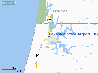
Lakeside State Airport (FAA LID: 9S3), is a public airport located in Lakeside in Coos County, Oregon, USA.
The above content comes from Wikipedia and is published under free licenses – click here to read more.
Location & QuickFacts
| FAA Information Effective: | 2008-09-25 |
| Airport Identifier: | 9S3 |
| Airport Status: | Operational |
| Longitude/Latitude: | 124-10-49.4110W/43-34-59.4130N
-124.180392/43.583170 (Estimated) |
| Elevation: | 20 ft / 6.10 m (Estimated) |
| Land: | 31 acres |
| From nearest city: | 0 nautical miles NW of Lakeside, OR |
| Location: | Coos County, OR |
| Magnetic Variation: | 19E (1985) |
Owner & Manager
| Ownership: | Publicly owned |
| Owner: | City Of Lakeside |
| Address: | 915 North Lake Road
Lakeside, OR 97449 |
| Phone number: | 541-759-3011 |
| Manager: | Charlie Hill |
| Address: | 915 Nothe Lake Road
Lakeside, OR 97449 |
| Phone number: | 541-759-3011 |
Airport Operations and Facilities
| Airport Use: | Open to public |
| Wind indicator: | Yes |
| Segmented Circle: | Yes
NON STD, CIRCLE OF TIRES. |
| Control Tower: | No |
| Landing fee charge: | No |
| Sectional chart: | Klamath Falls |
| Region: | ANM - Northwest Mountain |
| Traffic Pattern Alt: | 1000 ft |
| Boundary ARTCC: | ZSE - Seattle |
| Tie-in FSS: | MMV - Mc Minnville |
| FSS on Airport: | No |
| FSS Toll Free: | 1-800-WX-BRIEF |
| NOTAMs Facility: | MMV (NOTAM-d service avaliable) |
Airport Communications
Airport Services
| Airframe Repair: | NONE |
| Power Plant Repair: | NONE |
| Bottled Oxygen: | NONE |
| Bulk Oxygen: | NONE |
Runway Information
Runway 15/33
| Dimension: | 2150 x 100 ft / 655.3 x 30.5 m |
| Surface: | TURF, Good Condition |
| |
Runway 15 |
Runway 33 |
| Traffic Pattern: | Left | Left |
| Obstruction: | 55 ft trees, 500.0 ft from runway, 50 ft right of centerline, 9:1 slope to clear | 170 ft trees, 2490.0 ft from runway, 100L/ ft right of centerline, 14:1 slope to clear |
|
Radio Navigation Aids
| ID |
Type |
Name |
Ch |
Freq |
Var |
Dist |
| RBG | NDB | Roseburg | | 400.00 | 20E | 41.6 nm |
| RBG | VOR/DME | Roseburg | 019X | 108.20 | 20E | 43.5 nm |
| OTH | VORTAC | North Bend | 058X | 112.10 | 18E | 10.1 nm |
Remarks
Images and information placed above are from
http://www.airport-data.com/airport/9S3/
We thank them for the data!
| General Info
|
| Country |
United States
|
| State |
OREGON
|
| FAA ID |
9S3
|
| Latitude |
43-34-59.413N
|
| Longitude |
124-10-49.411W
|
| Elevation |
20 feet
|
| Near City |
LAKESIDE
|
We don't guarantee the information is fresh and accurate. The data may
be wrong or outdated.
For more up-to-date information please refer to other sources.
|
|


