 |
|
| George Felt Airport |
| IATA: none – ICAO: FAA: 5S1 |
| Summary |
| Airport type |
Public |
| Operator |
Private Owner |
| Location |
Roseburg, Oregon |
| Elevation AMSL |
428 ft / 130 m |
| Coordinates |
43°13′29.4160″N 123°23′49.2970″W / 43.22483778°N 123.39702694°W / 43.22483778; -123.39702694Coordinates: 43°13′29.4160″N 123°23′49.2970″W / 43.22483778°N 123.39702694°W / 43.22483778; -123.39702694 |
| Runways |
| Direction |
Length |
Surface |
| ft |
m |
| 10/28 |
2300 |
701 |
Turf |
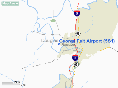
George Felt Airport (FAA LID: 5S1), is a public airport located three miles (4.8 km) west of Roseburg in Douglas County, Oregon, USA.
The above content comes from Wikipedia and is published under free licenses – click here to read more.
Location & QuickFacts
| FAA Information Effective: | 2008-09-25 |
| Airport Identifier: | 5S1 |
| Airport Status: | Operational |
| Longitude/Latitude: | 123-23-49.2670W/43-13-29.4160N
-123.397019/43.224838 (Estimated) |
| Elevation: | 428 ft / 130.45 m (Estimated) |
| Land: | 76 acres |
| From nearest city: | 3 nautical miles W of Roseburg, OR |
| Location: | Douglas County, OR |
| Magnetic Variation: | 18E (1985) |
Owner & Manager
| Ownership: | Privately owned |
| Owner: | Gil Peterson |
| Address: | Po Box 240
Winchester, OR 97495 |
| Phone number: | 541-672-0937 |
| Manager: | John Abercrombie |
| Address: | 415 Nw Felt
Roseburg, OR 97470 |
| Phone number: | 541-673-7709 |
Airport Operations and Facilities
| Airport Use: | Open to public |
| Wind indicator: | Yes |
| Control Tower: | No |
| Landing fee charge: | No |
| Sectional chart: | Klamath Falls |
| Region: | ANM - Northwest Mountain |
| Boundary ARTCC: | ZSE - Seattle |
| Tie-in FSS: | MMV - Mc Minnville |
| FSS on Airport: | No |
| FSS Toll Free: | 1-800-WX-BRIEF |
| NOTAMs Facility: | MMV (NOTAM-d service avaliable) |
Airport Communications
Airport Services
| Airframe Repair: | NONE |
| Power Plant Repair: | NONE |
| Bottled Oxygen: | NONE |
| Bulk Oxygen: | NONE |
Runway Information
Runway 10/28
| Dimension: | 2300 x 100 ft / 701.0 x 30.5 m |
| Surface: | TURF, Good Condition |
| |
Runway 10 |
Runway 28 |
| Traffic Pattern: | Left | Right |
| Obstruction: | 7 ft trees, 30.0 ft from runway, 4:1 slope to clear | 70 ft trees, 1182.0 ft from runway, 16:1 slope to clear |
|
Radio Navigation Aids
| ID |
Type |
Name |
Ch |
Freq |
Var |
Dist |
| RBG | NDB | Roseburg | | 400.00 | 20E | 1.8 nm |
| RBG | VOR/DME | Roseburg | 019X | 108.20 | 20E | 3.2 nm |
| OTH | VORTAC | North Bend | 058X | 112.10 | 18E | 35.6 nm |
| OED | VORTAC | Rogue Valley | 083X | 113.60 | 19E | 49.6 nm |
Remarks
- BIRD HAZARD--MIGRATORY FLOCKS OF WATERFOWL ON & INVOF ARPT.
- DEER FREQUENTLY ON RY.
- SOFT EARTH OFF RY & TWY WHEN WET.
- FOR NOISE ABATEMENT; FLY TO RIVER BEFORE TURNING.
- RY 10 VINEYARD AT 30 FT +7 FT POLES; STRONG WIRES +6 FT ACROSS APCH.
- ESTABD PRIOR TO 1959.
Images and information placed above are from
http://www.airport-data.com/airport/5S1/
We thank them for the data!
| General Info
|
| Country |
United States
|
| State |
OREGON
|
| FAA ID |
5S1
|
| Latitude |
43-13-29.416N
|
| Longitude |
123-23-49.267W
|
| Elevation |
428 feet
|
| Near City |
ROSEBURG
|
We don't guarantee the information is fresh and accurate. The data may
be wrong or outdated.
For more up-to-date information please refer to other sources.
|
|


