|
|
Eastern Oregon Rgnl At Pendleton Airport |
| Eastern Oregon Regional Airport |
 |
| IATA: PDT – ICAO: KPDT |
| Summary |
| Airport type |
Public |
| Operator |
City of Pendleton |
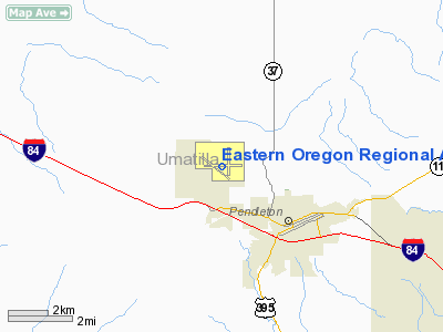
| Location |
Pendleton, Oregon |
| Elevation AMSL |
1,497 ft / 456.3 m |
| Coordinates |
45°41′42″N 118°50′29″W / 45.695°N 118.84139°W / 45.695; -118.84139Coordinates: 45°41′42″N 118°50′29″W / 45.695°N 118.84139°W / 45.695; -118.84139 |
| Runways |
| Direction |
Length |
Surface |
| ft |
m |
| 7/25 |
6,300 |
1,920 |
Asphalt |
| 11/29 |
5,581 |
1,701 |
Asphalt |
| 16/34 |
4,341 |
1,323 |
Asphalt |
Eastern Oregon Regional Airport (IATA: PDT, ICAO: KPDT), also known as Eastern Oregon Regional Airport at Pendleton, is a public airport located three miles (5 km) northwest of the central business district (CBD) of Pendleton, a city in Umatilla County, Oregon, USA. The airport covers 2,273 acres (920 ha) and has three runways. It is used primarily for general aviation, but is also served by one commercial airline. Service is subsidized by the Essential Air Service program. Airline and destinations
| Airlines |
Destinations |
| SeaPort Airlines |
Portland (OR) |
Cargo carriers
- FedEx Express
- UPS Airlines
The above content comes from Wikipedia and is published under free licenses – click here to read more.
Location & QuickFacts
| FAA Information Effective: | 2008-09-25 |
| Airport Identifier: | PDT |
| Airport Status: | Operational |
| Longitude/Latitude: | 118-50-29.2000W/45-41-42.2000N
-118.841444/45.695056 (Estimated) |
| Elevation: | 1497 ft / 456.29 m (Surveyed) |
| Land: | 2273 acres |
| From nearest city: | 3 nautical miles NW of Pendleton, OR |
| Location: | Umatilla County, OR |
| Magnetic Variation: | 16E (2005) |
Owner & Manager
| Ownership: | Publicly owned |
| Owner: | City Of Pendleton |
| Address: | 2016 Airport Road
Pendleton, OR 97801 |
| Phone number: | 541-276-7754 |
| Manager: | Larry Dalrymple |
| Address: | 2016 Airport Road
Pendleton, OR 97801 |
| Phone number: | 541-276-7754 |
Airport Operations and Facilities
| Airport Use: | Open to public |
| Wind indicator: | Yes |
| Segmented Circle: | Yes |
| Control Tower: | Yes |
| Lighting Schedule: | DUSK-DAWN
ACTVT MALSR RY 25; ODALS RY 07; HIRL RY 07/25; MIRL RY 11/29; REIL RY 11 & 29 WHEN ATCT CLSD - CTAF. |
| Beacon Color: | Clear-Green (lighted land airport) |
| Landing fee charge: | No |
| Sectional chart: | Seattle |
| Region: | ANM - Northwest Mountain |
| Boundary ARTCC: | ZSE - Seattle |
| Tie-in FSS: | MMV - Mc Minnville |
| FSS on Airport: | No |
| FSS Toll Free: | 1-800-WX-BRIEF |
| NOTAMs Facility: | PDT (NOTAM-d service avaliable) |
| Certification type/date: | I A S 05/1973
CLSD TO UNSKED ACR OPN WITH MORE THAN 30 PSGR SEATS EXCP PPR 24 HRS CALL 541-276-4411. |
| Federal Agreements: | NGPY3 |
Airport Communications
| CTAF: | 119.700 |
| Unicom: | 122.950 |
Airport Services
| Fuel available: | 100LLA1+ MOGAS |
| Airframe Repair: | MAJOR |
| Power Plant Repair: | MAJOR |
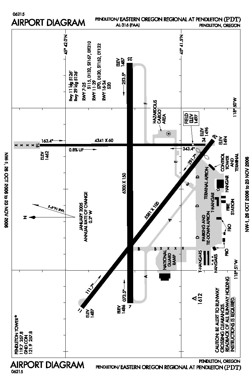
Runway Information
Runway 07/25
| Dimension: | 6301 x 150 ft / 1920.5 x 45.7 m |
| Surface: | ASPH, Good Condition |
| Surface Treatment: | Porous Friction Course |
| Weight Limit: | Single wheel: 115000 lbs.
Dual wheel: 132000 lbs.
Dual tandem wheel: 210000 lbs. |
| Edge Lights: | High |
| |
Runway 07 |
Runway 25 |
| Longitude: | 118-51-12.1397W | 118-49-43.3807W |
| Latitude: | 45-41-43.2175N | 45-41-43.3756N |
| Elevation: | 1486.00 ft | 1486.00 ft |
| Alignment: | 90 | 127 |
| ILS Type: | | ILS
|
| Traffic Pattern: | Left | Left |
| Markings: | Non-precision instrument, Good Condition | Precision instrument, Good Condition |
| Crossing Height: | 47.00 ft | 55.00 ft |
| VASI: | 4-box on right side | 4-light PAPI on left side |
| Visual Glide Angle: | 3.00° | 3.00° |
| RVR Equipment: | | touchdown |
| Approach lights: | ODALS | MALSR |
| Obstruction: | 8 ft gnd, 200.0 ft from runway, 500 ft right of centerline | , 50:1 slope to clear |
|
Runway 11/29
| Dimension: | 5581 x 100 ft / 1701.1 x 30.5 m |
| Surface: | ASPH, Good Condition |
| Surface Treatment: | Saw-cut or plastic Grooved |
| Weight Limit: | Single wheel: 70000 lbs.
Dual wheel: 120000 lbs.
Dual tandem wheel: 122000 lbs. |
| Edge Lights: | Medium |
| |
Runway 11 |
Runway 29 |
| Longitude: | 118-51-13.7458W | 118-50-11.8871W |
| Latitude: | 45-41-55.7399N | 45-41-21.7273N |
| Elevation: | 1487.00 ft | 1495.00 ft |
| Alignment: | 127 | 127 |
| Traffic Pattern: | Left | Left |
| Markings: | Basic, Good Condition | Basic, Good Condition |
| Crossing Height: | 47.00 ft | 35.00 ft |
| Displaced threshold: | 0.00 ft | 456.00 ft |
| VASI: | 4-light PAPI on left side | 4-light PAPI on left side |
| Visual Glide Angle: | 3.00° | 3.00° |
| Runway End Identifier: | Yes | Yes |
| Decleard distances: | Take off run available 5581.00 ft
Take off distance available 5581.00 ft
Actual stop distance available 5581.00 ft
Landing distance available 5581.00 ft
| Take off run available 5581.00 ft
Take off distance available 5581.00 ft
Actual stop distance available 5581.00 ft
Landing distance available 5125.00 ft
|
|
Runway 16/34
| Dimension: | 4341 x 60 ft / 1323.1 x 18.3 m |
| Surface: | ASPH, Fair Condition |
| Weight Limit: | Single wheel: 20000 lbs. |
| |
Runway 16 |
Runway 34 |
| Longitude: | 118-50-13.7605W | 118-50-13.5337W |
| Latitude: | 45-42-06.6480N | 45-41-23.7935N |
| Elevation: | 1462.00 ft | 1496.00 ft |
| Alignment: | 127 | 127 |
| Traffic Pattern: | Left | Left |
| Markings: | Basic, Fair Condition | Basic, Fair Condition |
|
Radio Navigation Aids
| ID |
Type |
Name |
Ch |
Freq |
Var |
Dist |
| PD | NDB | Foris | | 230.00 | 20E | 4.7 nm |
| LGD | NDB | La Grande | | 296.00 | 17E | 42.6 nm |
| ALW | VOR/DME | Walla Walla | 111X | 116.40 | 20E | 32.9 nm |
| PSC | VOR/DME | Pasco | 021X | 108.40 | 20E | 36.0 nm |
| PDT | VORTAC | Pendleton | 094X | 114.70 | 20E | 4.1 nm |
Remarks
- PILOTS SHALL EXER EXTRM CTN AT INT OF RAMP & RWY 29 NORTH END OF TRML BLDG; AREA OBSTD FROM VIEW OF TWR BY TRML BLDG.
- TWY B CLSD SOUTH OF TWY A.
- DEER ON & INVOF ARPT APR AND AUG, ESPECIALLY MORNINGS AND EVENINGS.
- ESTABD PRIOR TO 1959 /1934/.
Images and information placed above are from
http://www.airport-data.com/airport/PDT/
We thank them for the data!
| General Info
|
| Country |
United States
|
| State |
OREGON
|
| FAA ID |
PDT
|
| Latitude |
45-41-42.200N
|
| Longitude |
118-50-29.200W
|
| Elevation |
1497 feet
|
| Near City |
PENDLETON
|
We don't guarantee the information is fresh and accurate. The data may
be wrong or outdated.
For more up-to-date information please refer to other sources.
|
|