 |
|
| Chiloquin State Airport |
| IATA: none – ICAO: - FAA: 2S7 |
| Summary |
| Airport type |
Public |
| Operator |
Oregon Department of Aviation |
| Location |
Chiloquin, Oregon |
| Elevation AMSL |
4217 ft / 1285 m |
| Coordinates |
42°34′59.4900″N 121°52′34.0540″W / 42.5831917°N 121.87612611°W / 42.5831917; -121.87612611Coordinates: 42°34′59.4900″N 121°52′34.0540″W / 42.5831917°N 121.87612611°W / 42.5831917; -121.87612611 |
| Runways |
| Direction |
Length |
Surface |
| ft |
m |
| 17/35 |
3735 |
1138 |
Asphalt |
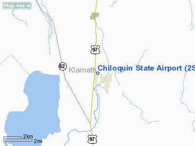
Chiloquin State Airport (FAA LID: 2S7), is a public airport located one mile (1.6 km) west of the city of Chiloquin in Klamath County, Oregon, USA. The airport was established in 1946 by the City of Chiloquin. Ownership was transferred in 1960 to the State of Oregon.
The above content comes from Wikipedia and is published under free licenses – click here to read more.
Location & QuickFacts
| FAA Information Effective: | 2008-09-25 |
| Airport Identifier: | 2S7 |
| Airport Status: | Operational |
| Longitude/Latitude: | 121-52-34.0540W/42-34-59.4900N
-121.876126/42.583192 (Estimated) |
| Elevation: | 4217 ft / 1285.34 m (Estimated) |
| Land: | 115 acres |
| From nearest city: | 1 nautical miles W of Chiloquin, OR |
| Location: | Klamath County, OR |
| Magnetic Variation: | 18E (1985) |
Owner & Manager
| Ownership: | Publicly owned |
| Owner: | Oregon Dept. Of Aviation |
| Address: | 3040 25th St, Se
Salem, OR 97302-1125 |
| Phone number: | 503-378-4880 |
| Manager: | State Airports Mgr |
| Address: | 3040 25th St, Se
Salem, OR 97302-1125 |
| Phone number: | 503-378-4880 |
Airport Operations and Facilities
| Airport Use: | Open to public |
| Wind indicator: | Yes |
| Segmented Circle: | Yes |
| Control Tower: | No |
| Lighting Schedule: | DUSK-DAWN
ACTVT MIRL RY 17/35 - CTAF. |
| Beacon Color: | Clear-Green (lighted land airport) |
| Landing fee charge: | No |
| Sectional chart: | Klamath Falls |
| Region: | ANM - Northwest Mountain |
| Traffic Pattern Alt: | 1000 ft |
| Boundary ARTCC: | ZSE - Seattle |
| Tie-in FSS: | MMV - Mc Minnville |
| FSS on Airport: | No |
| FSS Toll Free: | 1-800-WX-BRIEF |
| NOTAMs Facility: | MMV (NOTAM-d service avaliable) |
| Federal Agreements: | NGY |
Airport Communications
Airport Services
| Airframe Repair: | NONE |
| Power Plant Repair: | NONE |
| Bottled Oxygen: | NONE |
| Bulk Oxygen: | NONE |
Runway Information
Runway 17/35
| Dimension: | 3735 x 60 ft / 1138.4 x 18.3 m |
| Surface: | ASPH, Good Condition |
| Weight Limit: | Single wheel: 10000 lbs. |
| Edge Lights: | Medium |
| |
Runway 17 |
Runway 35 |
| Traffic Pattern: | Left | Left |
| Markings: | Basic, Fair Condition | Basic, Good Condition |
| Displaced threshold: | 420.00 ft | 0.00 ft |
| Obstruction: | 125 ft tree, 1410.0 ft from runway, 120 ft left of centerline, 9:1 slope to clear
APCH SLOPE 14:1 TO DSPLCD THLD. | 106 ft tree, 411.0 ft from runway, 120 ft left of centerline, 1:1 slope to clear |
|
Radio Navigation Aids
| ID |
Type |
Name |
Ch |
Freq |
Var |
Dist |
| LFA | NDB | Merrill | | 347.00 | 17E | 37.4 nm |
| MEF | NDB | Medford | | 356.00 | 19E | 45.9 nm |
| LMT | VORTAC | Klamath Falls | 106X | 115.90 | 17E | 26.7 nm |
| OED | VORTAC | Rogue Valley | 083X | 113.60 | 19E | 46.3 nm |
| MFR | VOT | Medford-jackson County | | 117.20 | | 45.9 nm |
Remarks
- DOWNDRAFT AREA NORTH OF RY.
- TFC PATTERN ALT 1000' AGL.
- IRREGULAR WINTER MAINTENANCE; ARPT MAY BE CLOSED DUE TO SNOW.
- ESTABLISHED PRIOR TO 1959.
Images and information placed above are from
http://www.airport-data.com/airport/2S7/
We thank them for the data!
| General Info
|
| Country |
United States
|
| State |
OREGON
|
| FAA ID |
2S7
|
| Latitude |
42-34-59.490N
|
| Longitude |
121-52-34.054W
|
| Elevation |
4217 feet
|
| Near City |
CHILOQUIN
|
We don't guarantee the information is fresh and accurate. The data may
be wrong or outdated.
For more up-to-date information please refer to other sources.
|
|


