|
|
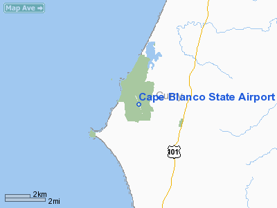
Cape Blanco State Airport |
| Cape Blanco State Airport |
 |
| IATA: none – ICAO: - FAA: 5S6 |
| Summary |
| Airport type |
Public |
| Operator |
Oregon Department of Aviation |
| Location |
Denmark, Oregon |
| Elevation AMSL |
214 ft / 65.2 m |
| Coordinates |
42°51′28.3900″N 124°31′03.3900″W / 42.8578861°N 124.5176083°W / 42.8578861; -124.5176083Coordinates: 42°51′28.3900″N 124°31′03.3900″W / 42.8578861°N 124.5176083°W / 42.8578861; -124.5176083 |
| Runways |
| Direction |
Length |
Surface |
| ft |
m |
| 14/32 |
5100 |
1554 |
asphalt |
Cape Blanco State Airport (FAA LID: 5S6), is a public airport located four miles (6.4 km) southwest of Denmark in Curry County, Oregon, USA. The airport was constructed during World War II between 1944 & 1945 and was originally leased to the US Navy. Previous owners include Curry County and the Oregon State Highway Department.
The above content comes from Wikipedia and is published under free licenses – click here to read more.
Location & QuickFacts
| FAA Information Effective: | 2008-09-25 |
| Airport Identifier: | 5S6 |
| Airport Status: | Operational |
| Longitude/Latitude: | 124-31-03.3900W/42-51-28.3900N
-124.517608/42.857886 (Estimated) |
| Elevation: | 214 ft / 65.23 m (Surveyed) |
| Land: | 170 acres |
| From nearest city: | 4 nautical miles SW of Denmark, OR |
| Location: | Curry County, OR |
| Magnetic Variation: | 18E (1985) |
Owner & Manager
| Ownership: | Publicly owned |
| Owner: | Oregon Dept Of Aviation |
| Address: | 3040 25th St Se
Salem, OR 97310 |
| Phone number: | 503-378-4880 |
| Manager: | State Airports Manager |
| Address: | 3040 25th St Se
Salem, OR 97310 |
| Phone number: | 503-378-4880 |
Airport Operations and Facilities
| Airport Use: | Open to public |
| Wind indicator: | Yes |
| Segmented Circle: | Yes
NSTD WHITE TIRES. |
| Control Tower: | No |
| Landing fee charge: | No |
| Sectional chart: | Klamath Falls |
| Region: | ANM - Northwest Mountain |
| Traffic Pattern Alt: | 1000 ft |
| Boundary ARTCC: | ZSE - Seattle |
| Tie-in FSS: | MMV - Mc Minnville |
| FSS on Airport: | No |
| FSS Toll Free: | 1-800-WX-BRIEF |
| NOTAMs Facility: | MMV (NOTAM-d service avaliable) |
| Federal Agreements: | 3 |
Airport Communications
Airport Services
| Airframe Repair: | NONE |
| Power Plant Repair: | NONE |
| Bottled Oxygen: | NONE |
| Bulk Oxygen: | NONE |
Runway Information
Runway 14/32
| Dimension: | 5100 x 150 ft / 1554.5 x 45.7 m |
| Surface: | ASPH, Fair Condition |
| Weight Limit: | Single wheel: 115000 lbs.
Dual wheel: 185000 lbs.
Dual tandem wheel: 340000 lbs. |
| |
Runway 14 |
Runway 32 |
| Traffic Pattern: | Left | Left |
| Markings: | Basic, Good Condition | Basic, Good Condition |
| Obstruction: | 20 ft trees, 957.0 ft from runway, 37:1 slope to clear | 3 ft brush, 275.0 ft from runway, 40 ft right of centerline, 25:1 slope to clear |
|
Radio Navigation Aids
| ID |
Type |
Name |
Ch |
Freq |
Var |
Dist |
| OTH | VORTAC | North Bend | 058X | 112.10 | 18E | 36.9 nm |
Remarks
- TFC PATTERN ALT 1000' AGL.
- ESTABD PRIOR TO 1959.
Images and information placed above are from
http://www.airport-data.com/airport/5S6/
We thank them for the data!
| General Info
|
| Country |
United States
|
| State |
OREGON
|
| FAA ID |
5S6
|
| Latitude |
42-51-28.390N
|
| Longitude |
124-31-03.390W
|
| Elevation |
214 feet
|
| Near City |
DENMARK
|
We don't guarantee the information is fresh and accurate. The data may
be wrong or outdated.
For more up-to-date information please refer to other sources.
|
|