 |
|
| Burns Municipal Airport |
| IATA: BNO – ICAO: KBNO |
| Summary |
| Airport type |
Public |
| Operator |
City of Burns |
| Location |
4148 |
| Elevation AMSL |
1264.3 ft / m |
| Coordinates |
43°35′30.8670″N 118°57′19.7510″W / 43.5919075°N 118.95548639°W / 43.5919075; -118.95548639Coordinates: 43°35′30.8670″N 118°57′19.7510″W / 43.5919075°N 118.95548639°W / 43.5919075; -118.95548639 |
| Runways |
| Direction |
Length |
Surface |
| ft |
m |
| 12/30 |
5100 |
1554 |
Asphalt |
| 3/21 |
4600 |
1402 |
Concrete |
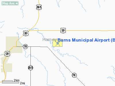
Burns Municipal Airport (IATA: BNO, ICAO: KBNO), is a public airport located five miles (8 km) east of the city of Burns in Harney County, Oregon, USA.
The above content comes from Wikipedia and is published under free licenses – click here to read more.
Location & QuickFacts
| FAA Information Effective: | 2008-09-25 |
| Airport Identifier: | BNO |
| Airport Status: | Operational |
| Longitude/Latitude: | 118-57-19.5710W/43-35-30.8670N
-118.955436/43.591907 (Estimated) |
| Elevation: | 4148 ft / 1264.31 m (Surveyed) |
| Land: | 825 acres |
| From nearest city: | 5 nautical miles E of Burns, OR |
| Location: | Harney County, OR |
| Magnetic Variation: | 18E (1980) |
Owner & Manager
| Ownership: | Publicly owned |
| Owner: | City Of Burns |
| Address: | 242 S. Broadway
Burns, OR 97720 |
| Phone number: | 541-573-5255 |
| Manager: | Walter Sitz |
| Address: | 33003 Airport Ln.
Burns, OR 97720 |
| Phone number: | 541-573-6139
AMGR EMERG PHONE: (541) 493-2385; FBO: (541) 573-3818 |
Airport Operations and Facilities
| Airport Use: | Open to public |
| Wind indicator: | Yes |
| Segmented Circle: | Yes |
| Control Tower: | No |
| Lighting Schedule: | DUSK-DAWN
ACTVT MIRL RYS 03/21 & 12/30, PAPI RYS 03 & 21, VASI RYS 12 & 30, & REILS RYS 03, 21, 12, & 30 - CTAF. |
| Beacon Color: | Clear-Green (lighted land airport) |
| Landing fee charge: | No |
| Sectional chart: | Klamath Falls |
| Region: | ANM - Northwest Mountain |
| Boundary ARTCC: | ZLC - Salt Lake City |
| Tie-in FSS: | MMV - Mc Minnville |
| FSS on Airport: | No |
| FSS Toll Free: | 1-800-WX-BRIEF |
| NOTAMs Facility: | BNO (NOTAM-d service avaliable) |
| Federal Agreements: | NGY3 |
Airport Communications
| CTAF: | 122.800 |
| Unicom: | 122.800 |
Airport Services
| Fuel available: | 100LLA
SELF SERVE CARD LOCK FUEL AVAIL 24 HRS. |
| Airframe Repair: | MAJOR |
| Power Plant Repair: | MAJOR |
| Bottled Oxygen: | NONE
BOTTLE OXYGEN OBTAINABLE: 1/2 HR. |
| Bulk Oxygen: | NONE |
Runway Information
Runway 03/21
| Dimension: | 4600 x 60 ft / 1402.1 x 18.3 m |
| Surface: | CONC, Good Condition |
| Weight Limit: | Single wheel: 30000 lbs. |
| Edge Lights: | Medium |
| |
Runway 03 |
Runway 21 |
| Longitude: | 118-57-34.9870W | 118-56-48.8890W |
| Latitude: | 43-35-14.8720N | 43-35-45.5520N |
| Elevation: | 4146.00 ft | 4142.00 ft |
| Alignment: | 48 | 127 |
| Traffic Pattern: | Left | Left |
| Markings: | Basic, Good Condition | Basic, Good Condition |
| Crossing Height: | 40.00 ft | 40.00 ft |
| Displaced threshold: | 600.00 ft | 0.00 ft |
| VASI: | 2-light PAPI on left side | 2-light PAPI on left side |
| Visual Glide Angle: | 3.00° | 3.00° |
| Runway End Identifier: | Yes | Yes |
| Obstruction: | 32 ft pline, 1132.0 ft from runway, 18 ft left of centerline, 29:1 slope to clear
RWY 03 APRCH RATIO 50:1 TO DSPLCD THR. | , 50:1 slope to clear |
|
Runway 12/30
| Dimension: | 5100 x 75 ft / 1554.5 x 22.9 m |
| Surface: | ASPH, Fair Condition |
| Weight Limit: | Single wheel: 30000 lbs.
Dual wheel: 50000 lbs.
Dual tandem wheel: 90000 lbs. |
| Edge Lights: | Medium |
| |
Runway 12 |
Runway 30 |
| Longitude: | 118-57-51.1615W | 118-57-01.7539W |
| Latitude: | 43-35-49.1089N | 43-35-13.8057N |
| Elevation: | 4147.00 ft | 4144.00 ft |
| Alignment: | 127 | 127 |
| Traffic Pattern: | Left | Left |
| Markings: | Basic, Good Condition | Non-precision instrument, Good Condition |
| Crossing Height: | 45.00 ft | 45.00 ft |
| VASI: | 2-box on left side | 2-box on left side |
| Visual Glide Angle: | 3.00° | 3.00° |
| Runway End Identifier: | Yes | Yes |
| Obstruction: | , 50:1 slope to clear | 14 ft road, 900.0 ft from runway, 205 ft left of centerline, 50:1 slope to clear |
|
Radio Navigation Aids
| ID |
Type |
Name |
Ch |
Freq |
Var |
Dist |
Remarks
- FLOCKS OF LARGE BIRDS INVOF ARPT FEB - MAY & SEP - OCT.
- ESTABD PRIOR TO 1959.
Images and information placed above are from
http://www.airport-data.com/airport/BNO/
We thank them for the data!
| General Info
|
| Country |
United States
|
| State |
OREGON
|
| FAA ID |
BNO
|
| Latitude |
43-35-31.660N
|
| Longitude |
118-57-17.924W
|
| Elevation |
4148 feet
|
| Near City |
BURNS
|
We don't guarantee the information is fresh and accurate. The data may
be wrong or outdated.
For more up-to-date information please refer to other sources.
|
|


