 |
|
| Bandon State Airport |
 |
| IATA: BDY – ICAO: - FAA: S05 |
| Summary |
| Airport type |
Public |
| Operator |
Oregon Department of Aviation |
| Location |
Bandon, Oregon |
| Elevation AMSL |
123 ft / 37 m |
| Coordinates |
43°05′11.2600″N 124°24′28.3100″W / 43.0864611°N 124.4078639°W / 43.0864611; -124.4078639Coordinates: 43°05′11.2600″N 124°24′28.3100″W / 43.0864611°N 124.4078639°W / 43.0864611; -124.4078639 |
| Runways |
| Direction |
Length |
Surface |
| ft |
m |
| 16/34 |
3601 |
1098 |
Asphalt |
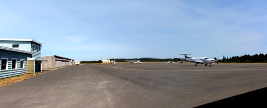
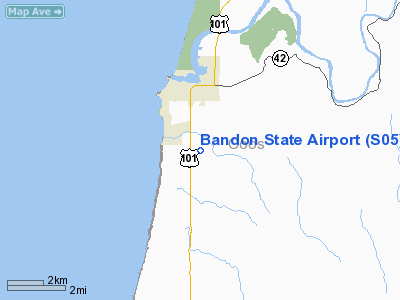
Bandon State Airport (IATA: BDY, FAA LID: S05), is a public airport located two miles (3.2 km) Southeast of the city of Bandon in Coos County, Oregon, USA.
The above content comes from Wikipedia and is published under free licenses – click here to read more.
Location & QuickFacts
| FAA Information Effective: | 2008-09-25 |
| Airport Identifier: | S05 |
| Airport Status: | Operational |
| Longitude/Latitude: | 124-24-28.3000W/43-05-11.3000N
-124.407861/43.086472 (Estimated) |
| Elevation: | 122 ft / 37.19 m (Surveyed) |
| Land: | 132 acres |
| From nearest city: | 2 nautical miles SE of Bandon, OR |
| Location: | Coos County, OR |
| Magnetic Variation: | 18E (1985) |
Owner & Manager
| Ownership: | Publicly owned |
| Owner: | Oregon Dept. Of Aviation |
| Address: | 3040 25th St Se
Salem, OR 97302-1125 |
| Phone number: | 503-378-4880 |
| Manager: | State Airports Mgr |
| Address: | 3040 25th St Se
Salem, OR 97302-1125 |
| Phone number: | 503-378-4880 |
Airport Operations and Facilities
| Airport Use: | Open to public |
| Wind indicator: | Yes |
| Segmented Circle: | Yes |
| Control Tower: | No |
| Lighting Schedule: | DUSK-DAWN
ACTVT MIRL RY 16/34; REIL RYS 16 & 34 AND PAPI RYS 16/34 - CTAF. |
| Beacon Color: | Clear-Green (lighted land airport) |
| Landing fee charge: | No |
| Sectional chart: | Klamath Falls |
| Region: | ANM - Northwest Mountain |
| Traffic Pattern Alt: | 1000 ft |
| Boundary ARTCC: | ZSE - Seattle |
| Tie-in FSS: | MMV - Mc Minnville |
| FSS on Airport: | No |
| FSS Toll Free: | 1-800-WX-BRIEF |
| NOTAMs Facility: | MMV (NOTAM-d service avaliable) |
| Federal Agreements: | NGY |
Airport Communications
| CTAF: | 122.800 |
| Unicom: | 122.800 |
Airport Services
| Fuel available: | 100LL |
| Airframe Repair: | MAJOR |
| Power Plant Repair: | MAJOR |
| Bottled Oxygen: | NONE |
| Bulk Oxygen: | NONE |
Runway Information
Runway 16/34
| Dimension: | 3601 x 60 ft / 1097.6 x 18.3 m |
| Surface: | ASPH, Good Condition |
| Weight Limit: | Single wheel: 12000 lbs. |
| Edge Lights: | Medium |
| |
Runway 16 |
Runway 34 |
| Longitude: | 124-24-29.0884W | 124-24-27.5259W |
| Latitude: | 43-05-29.0247N | 43-04-53.4859N |
| Elevation: | 105.00 ft | 122.00 ft |
| Alignment: | 127 | 127 |
| Traffic Pattern: | Left | Left |
| Markings: | Non-precision instrument, Good Condition | Non-precision instrument, Good Condition |
| Crossing Height: | 45.00 ft | 40.00 ft |
| VASI: | 4-light PAPI on left side | 4-light PAPI on left side |
| Visual Glide Angle: | 4.00° | 4.00° |
| Runway End Identifier: | Yes | Yes |
| Obstruction: | 80 ft trees, 1560.0 ft from runway, 17:1 slope to clear | 50 ft trees, 1350.0 ft from runway, 23:1 slope to clear |
|
Radio Navigation Aids
| ID |
Type |
Name |
Ch |
Freq |
Var |
Dist |
| RBG | NDB | Roseburg | | 400.00 | 20E | 46.9 nm |
| RBG | VOR/DME | Roseburg | 019X | 108.20 | 20E | 46.7 nm |
| OTH | VORTAC | North Bend | 058X | 112.10 | 18E | 22.4 nm |
Remarks
- TWY MKD WITH BLUE REFLECTORS.
- DEER INVOF RY & ARPT.
- ESTABD PRIOR TO 1959.
Images and information placed above are from
http://www.airport-data.com/airport/S05/
We thank them for the data!
| General Info
|
| Country |
United States
|
| State |
OREGON
|
| FAA ID |
S05
|
| Latitude |
43-05-14.391N
|
| Longitude |
124-24-34.408W
|
| Elevation |
119 feet
|
| Near City |
BANDON
|
We don't guarantee the information is fresh and accurate. The data may
be wrong or outdated.
For more up-to-date information please refer to other sources.
|
|


