 |
|
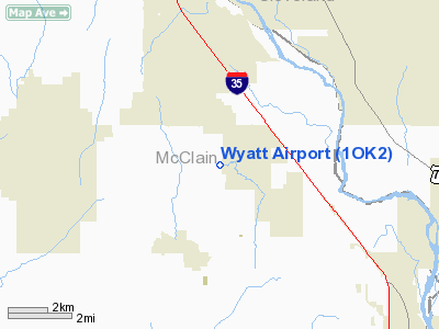
Location & QuickFacts
| FAA Information Effective: | 2008-09-25 |
| Airport Identifier: | 1OK2 |
| Airport Status: | Operational |
| Longitude/Latitude: | 097-28-11.1140W/35-05-55.2470N
-97.469754/35.098680 (Estimated) |
| Elevation: | 1163 ft / 354.48 m (Estimated) |
| Land: | 6 acres |
| From nearest city: | 5 nautical miles SE of Goldsby, OK |
| Location: | Mc Clain County, OK |
| Magnetic Variation: | 07E (1985) |
Owner & Manager
| Ownership: | Privately owned |
| Owner: | Russell A & Frances J Wyatt |
| Address: | 592 E. Cottonwood Road
Goldsby, OK 73093 |
| Phone number: | 405-288-2280 |
| Manager: | Russ Wyatt |
| Address: | 592 E. Cottonwood Road
Goldsby, OK 73093 |
| Phone number: | 405-288-2280 |
Airport Operations and Facilities
| Airport Use: | Private |
| Wind indicator: | Yes |
| Segmented Circle: | No |
| Control Tower: | No |
| Sectional chart: | Dallas-ft Worth |
| Region: | ASW - Southwest |
| Boundary ARTCC: | ZFW - Fort Worth |
| Tie-in FSS: | MLC - Mc Alester |
| FSS on Airport: | No |
| FSS Toll Free: | 1-800-WX-BRIEF |
Runway Information
Runway 17/35
| Dimension: | 2640 x 125 ft / 804.7 x 38.1 m |
| Surface: | TURF, |
| |
Runway 17 |
Runway 35 |
| Traffic Pattern: | Left | Left |
| Displaced threshold: | 200.00 ft | 0.00 ft |
| Obstruction: | 20 ft pline, 200.0 ft from runway | |
|
Radio Navigation Aids
| ID |
Type |
Name |
Ch |
Freq |
Var |
Dist |
| FSI | FAN MARKER | Trail | | | 09E | 49.8 nm |
| OUN | NDB | Norman | | 260.00 | 07E | 9.0 nm |
| OK | NDB | Tuloo | | 406.00 | 07E | 23.4 nm |
| OLR | NDB | Chickasha | | 290.00 | 07E | 24.7 nm |
| PVJ | NDB | Pauls Valley | | 384.00 | 06E | 25.9 nm |
| RQO | NDB | El Reno | | 335.00 | 07E | 34.9 nm |
| SRE | NDB | Seminole | | 278.00 | 06E | 40.4 nm |
| GGU | NDB | Prague | | 314.00 | 06E | 44.6 nm |
| LCY | NDB | Logan County | | 326.00 | 07E | 45.0 nm |
| CQB | NDB | Tilghman | | 396.00 | 06E | 49.2 nm |
| OFZ | NDB | Trail | | 388.00 | 09E | 49.8 nm |
| TIK | TACAN | Tinker | 105X | | 07E | 20.8 nm |
| PWA | VOR/DME | Wiley Post | 081X | 113.40 | 08E | 27.5 nm |
| ADH | VOR/DME | Ada | 125X | 117.80 | 06E | 43.2 nm |
| DUC | VOR/DME | Duncan | 047X | 111.00 | 09E | 48.3 nm |
| IRW | VORTAC | Will Rogers | 088X | 114.10 | 07E | 17.1 nm |
| IFI | VORTAC | Kingfisher | 094X | 114.70 | 09E | 49.9 nm |
| OKC | VOT | Oklahoma Will Rgs W | | 108.80 | | 18.8 nm |
Images and information placed above are from
http://www.airport-data.com/airport/1OK2/
We thank them for the data!
| General Info
|
| Country |
United States
|
| State |
OKLAHOMA
|
| FAA ID |
1OK2
|
| Latitude |
35-05-55.247N
|
| Longitude |
097-28-11.114W
|
| Elevation |
1163 feet
|
| Near City |
GOLDSBY
|
We don't guarantee the information is fresh and accurate. The data may
be wrong or outdated.
For more up-to-date information please refer to other sources.
|
|


