 |
|
| Wiley Post Airport |
| IATA: PWA – ICAO: KPWA – FAA LID: PWA |
| Summary |
| Airport type |
Public |
| Owner |
City of Oklahoma City |
| Operator |
Oklahoma City Airport Trust |
| Serves |
Oklahoma City, Oklahoma |
| Elevation AMSL |
1,299 ft / 396 m |
| Coordinates |
35°32′03″N 097°38′49″W / 35.53417°N 97.64694°W / 35.53417; -97.64694 |
| Website |
WileyPostAirport.com |
| Runways |
| Direction |
Length |
Surface |
| ft |
m |
| 13/31 |
4,213 |
1,284 |
Concrete |
| 17L/35R |
7,198 |
2,194 |
Concrete |
| 17R/35L |
5,000 |
1,524 |
Asphalt/Concrete |
| Statistics (2005) |
| Aircraft operations |
82,367 |
| Based aircraft |
453 |
| Sources: airport website and FAA |
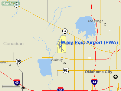
Wiley Post Airport (IATA: PWA, ICAO: KPWA, FAA LID: PWA) is a city-owned public-use airport located seven nautical miles (13 km) northwest of the central business district of Oklahoma City, in Oklahoma County, Oklahoma, United States.
It was named after Wiley Post, the first pilot to fly solo around the world, and holds the distinction of being named after a person who died in an airplane crash (as does the city's other major airport, Will Rogers World Airport - both men died in the same crash).
It is the FAA-designated reliever airport for Will Rogers World Airport and serves business and corporate air travelers and functions as a lively center for general aviation. In addition, the northwest Oklahoma City airport provides a thriving environment for aviation-related industry.
In 2007 Wiley Post logged 74,519 flight operations. This figure accounts for only those operations logged by the air traffic control tower which is open daily from 7 A.M. until 10 P.M.
The airport provides a base for over 300 aircraft in its fully leased hangars. These range from single and twin engine planes to turboprop and jet aircraft. A growing number of licensed private pilots consider Wiley Post their airport home, and their activities give the facility a strong community orientation.
The above content comes from Wikipedia and is published under free licenses – click here to read more.
 |
(Click on the photo to enlarge) |
Location & QuickFacts
| FAA Information Effective: | 2008-09-25 |
| Airport Identifier: | PWA |
| Airport Status: | Operational |
| Longitude/Latitude: | 097-38-49.4000W/35-32-03.0000N
-97.647056/35.534167 (Estimated) |
| Elevation: | 1300 ft / 396.24 m (Surveyed) |
| Land: | 1143 acres |
| From nearest city: | 7 nautical miles NW of Oklahoma City, OK |
| Location: | Oklahoma County, OK |
| Magnetic Variation: | 08E (1980) |
Owner & Manager
| Ownership: | Publicly owned |
| Owner: | City Of Oklahoma City |
| Address: | City Hall 200 North Walker
Oklahoma City, OK 73102 |
| Phone number: | 405-297-2345 |
| Manager: | Scott Keith
GEN AVIATION MNGR. |
| Address: | 5915 Philip J Rhoads Rm 104
Bethany, OK 73008 |
| Phone number: | 405-789-4061 |
Airport Operations and Facilities
| Airport Use: | Open to public |
| Wind indicator: | Yes |
| Segmented Circle: | Yes |
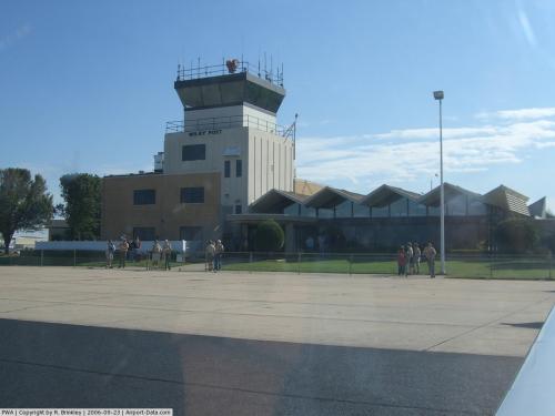
| Control Tower: | Yes |
| Lighting Schedule: | DUSK-DAWN
WHEN ATCT CLSD ACTVT HIRL RY 17L/35R & MALSR RY 17L - CTAF. |
| Beacon Color: | Clear-Green (lighted land airport) |
| Landing fee charge: | No |
| Sectional chart: | Dallas-ft Worth |
| Region: | ASW - Southwest |
| Boundary ARTCC: | ZFW - Fort Worth |
| Tie-in FSS: | MLC - Mc Alester |
| FSS on Airport: | No |
| FSS Toll Free: | 1-800-WX-BRIEF |
| NOTAMs Facility: | PWA (NOTAM-d service avaliable) |
| Federal Agreements: | NGY3 |
Airport Communications
| CTAF: | 126.900 |
| Unicom: | 122.950 |
Airport Services
| Fuel available: | 100LLA
FUEL AVBL 24 HRS SELF-SERVE WITH CREDIT CARD. |
| Airframe Repair: | MAJOR |
| Power Plant Repair: | MAJOR |
| Bottled Oxygen: | HIGH/LOW |
| Bulk Oxygen: | HIGH/LOW |
Runway Information
Runway 13/31
| Dimension: | 4214 x 100 ft / 1284.4 x 30.5 m |
| Surface: | CONC, Good Condition
SOUTH & NORTH 1000 FT CONC. |
| Weight Limit: | Single wheel: 35000 lbs.
Dual wheel: 50000 lbs.
Dual tandem wheel: 90000 lbs. |
| Edge Lights: | Medium |
| |
Runway 13 |
Runway 31 |
| Longitude: | 097-39-07.9001W | 097-38-31.8204W |
| Latitude: | 35-32-06.3560N | 35-31-36.9215N |
| Elevation: | 1270.00 ft | 1297.00 ft |
| Alignment: | 127 | 127 |
| Traffic Pattern: | Right | Left |
| Markings: | Non-precision instrument, Good Condition | Non-precision instrument, Good Condition |
| Decleard distances: | Take off run available 4214.00 ft
Take off distance available 4214.00 ft
Actual stop distance available 4214.00 ft
Landing distance available 4214.00 ft
| Take off run available 4214.00 ft
Take off distance available 4214.00 ft
Actual stop distance available 4214.00 ft
Landing distance available 4214.00 ft
|
|
Runway 17L/35R
| Dimension: | 7199 x 150 ft / 2194.3 x 45.7 m |
| Surface: | CONC, Good Condition
SOUTH & NORTH 1000 FT CONC. |
| Weight Limit: | Single wheel: 35000 lbs.
Dual wheel: 50000 lbs.
Dual tandem wheel: 90000 lbs. |
| Edge Lights: | High |
| |
Runway 17L |
Runway 35R |
| Longitude: | 097-38-43.8082W | 097-38-43.7918W |
| Latitude: | 35-32-39.6068N | 35-31-28.4144N |
| Elevation: | 1290.00 ft | 1300.00 ft |
| Alignment: | 127 | 127 |
| ILS Type: | ILS
| |
| Traffic Pattern: | Right | Left |
| Markings: | Precision instrument, Fair Condition | Precision instrument, Fair Condition |
| Crossing Height: | 54.00 ft | 45.00 ft |
| Displaced threshold: | 0.00 ft | 355.00 ft |
| VASI: | 4-light PAPI on left side | 4-light PAPI on left side |
| Visual Glide Angle: | 3.00° | 3.00° |
| Approach lights: | MALSR | |
| Decleard distances: | Take off run available 7199.00 ft
Take off distance available 7199.00 ft
Actual stop distance available 6844.00 ft
Landing distance available 6844.00 ft
| Take off run available 7199.00 ft
Take off distance available 7199.00 ft
Actual stop distance available 7199.00 ft
Landing distance available 6844.00 ft
|
|
Runway 17R/35L
| Dimension: | 5002 x 75 ft / 1524.6 x 22.9 m |
| Surface: | ASPH-CONC, Fair Condition
SOUTH & NORTH 1000 FT CONC. |
| Weight Limit: | Single wheel: 26000 lbs. |
| Edge Lights: | Medium |
| |
Runway 17R |
Runway 35L |
| Longitude: | 097-38-57.0989W | 097-38-57.0998W |
| Latitude: | 35-32-35.8606N | 35-31-46.3984N |
| Elevation: | 1283.00 ft | 1275.00 ft |
| Alignment: | 127 | 0 |
| Traffic Pattern: | Right | Left |
| Markings: | Non-precision instrument, Good Condition | Non-precision instrument, Good Condition |
| Crossing Height: | 25.00 ft | 31.00 ft |
| VASI: | 4-light PAPI on left side | 4-light PAPI on left side |
| Visual Glide Angle: | 3.00° | 3.00° |
| Decleard distances: | Take off run available 5002.00 ft
Take off distance available 5002.00 ft
Actual stop distance available 5002.00 ft
Landing distance available 5002.00 ft
| Take off run available 5002.00 ft
Take off distance available 5002.00 ft
Actual stop distance available 5002.00 ft
Landing distance available 5002.00 ft
|
|
Radio Navigation Aids
| ID |
Type |
Name |
Ch |
Freq |
Var |
Dist |
| OK | NDB | Tuloo | | 406.00 | 07E | 4.3 nm |
| RQO | NDB | El Reno | | 335.00 | 07E | 18.0 nm |
| OUN | NDB | Norman | | 260.00 | 07E | 19.3 nm |
| LCY | NDB | Logan County | | 326.00 | 07E | 21.9 nm |
| OLR | NDB | Chickasha | | 290.00 | 07E | 30.3 nm |
| CQB | NDB | Tilghman | | 396.00 | 06E | 42.0 nm |
| JWG | NDB | Watonga | | 359.00 | 07E | 42.8 nm |
| GGU | NDB | Prague | | 314.00 | 06E | 45.4 nm |
| CUH | NDB | Cushing | | 242.00 | 05E | 47.6 nm |
| TIK | TACAN | Tinker | 105X | | 07E | 14.3 nm |
| SWO | VOR/DME | Stillwater | 021X | 108.40 | 07E | 49.8 nm |
| IRW | VORTAC | Will Rogers | 088X | 114.10 | 07E | 10.7 nm |
| IFI | VORTAC | Kingfisher | 094X | 114.70 | 09E | 23.9 nm |
| OKC | VOT | Oklahoma Will Rgs W | | 108.80 | | 8.8 nm |
Remarks
- TOUCH & GO OR STOP & GO LNDGS NOT AUTHORIZED RY 13/31.
- FLOCKS OF BIRDS ON & INVOF ARPT ALL QUADRANTS.
- NOISE ABATEMENT PROC: ACFT IN EXCESS OF 12500 LBS DEPARTING RY 17L/35R CLIMB AT A MAX RATE CONSISTENT WITH SAFETY TO AN ALT OF 1500 FT AGL THEN REDUCE POWER SETTING & CLIMB RATE TO 3000 FT AGL OR 2 NM FM ARPT DEPENDING ON ATC & SAFETY CONDS.
- NUMEROUS ACFT UNDER THE CTL OF OKLAHOMA CITY APCH OPERATING IN WILEY POST CLASS D AIRSPACE ABV 3000 FT MSL & 1 MILE EAST OF WILEY POST ARPT ABV 2500 FT MSL.
- DURING HEAVY RAINS POSSIBLE PONDING WATER ON RY 17/35R AT INTERSECTION OF RY 13/31.
- RY 13/31 CLSD TO JETS.
- RY 13 CLSD TO TKOF & RY 31 CLSD TO LNDG FOR ACFT OVER 12500 LBS GWT.
- TPA FOR RY 17R/35L 600 FT AGL; 1000 FT AGL ALL OTHER RYS.
- RYS 13/31 AND 17R/35L UNLGTD 2200-0700.
- TWY C-1 NORTH OF RY 31 THLD AND TWY C FM 100 FT EAST OF TWY A EASTBOUND DESIGNATED NON-MOVEMENT AREA.
- PRE DATES THE ACT.
Images and information placed above are from
http://www.airport-data.com/airport/PWA/
We thank them for the data!
| General Info
|
| Country |
United States
|
| State |
OKLAHOMA
|
| FAA ID |
PWA
|
| Latitude |
35-32-04.380N
|
| Longitude |
097-38-49.976W
|
| Elevation |
1299 feet
|
| Near City |
OKLAHOMA CITY
|
We don't guarantee the information is fresh and accurate. The data may
be wrong or outdated.
For more up-to-date information please refer to other sources.
|
|


