 |
|
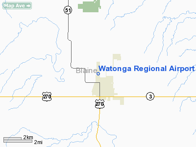
Location & QuickFacts
| FAA Information Effective: | 2008-09-25 |
| Airport Identifier: | JWG |
| Airport Status: | Operational |
| Longitude/Latitude: | 098-25-14.7000W/35-51-52.9000N
-98.420750/35.864694 (Estimated) |
| Elevation: | 1550 ft / 472.44 m (Estimated) |
| Land: | 120 acres |
| From nearest city: | 1 nautical miles NW of Watonga, OK |
| Location: | Blaine County, OK |
| Magnetic Variation: | 07E (1990) |
Owner & Manager
| Ownership: | Publicly owned |
| Owner: | City Of Watonga |
| Address: | 119 N. Weigle, P. O. Box 564
Watonga, OK 73772 |
| Phone number: | 580-623-4669 |
| Manager: | Bob Oler |
| Address: | Municipal Arpt Rt 3 Box 50
Watonga, OK 73772 |
| Phone number: | 580-623-7350 |
Airport Operations and Facilities
| Airport Use: | Open to public |
| Wind indicator: | Yes |
| Segmented Circle: | No |
| Control Tower: | No |
| Lighting Schedule: | DUSK-DAWN
MIRL RY 17/35 PRESET LOW INTST; TO INCR INTST ACTVT - CTAF. |
| Beacon Color: | Clear-Green (lighted land airport) |
| Landing fee charge: | No |
| Sectional chart: | Dallas-ft Worth |
| Region: | ASW - Southwest |
| Boundary ARTCC: | ZKC - Kansas City |
| Tie-in FSS: | MLC - Mc Alester |
| FSS on Airport: | No |
| FSS Toll Free: | 1-800-WX-BRIEF |
| NOTAMs Facility: | JWG (NOTAM-d service avaliable) |
| Federal Agreements: | N1 |
Airport Communications
| CTAF: | 122.800 |
| Unicom: | 122.800 |
Airport Services
| Fuel available: | 100LL |
| Bottled Oxygen: | NONE |
| Bulk Oxygen: | NONE |
Runway Information
Runway 17/35
| Dimension: | 4000 x 60 ft / 1219.2 x 18.3 m |
| Surface: | ASPH, Fair Condition |
| Pavement Class: | 3 /F/B/Y/T |
| Weight Limit: | Single wheel: 30000 lbs. |
| Edge Lights: | Medium |
| |
Runway 17 |
Runway 35 |
| Longitude: | 098-25-14.7150W | 098-25-14.7200W |
| Latitude: | 35-52-12.1910N | 35-51-32.6300N |
| Elevation: | 1550.00 ft | 1533.00 ft |
| Alignment: | 127 | 127 |
| Traffic Pattern: | Right | Left |
| Markings: | Non-precision instrument, Fair Condition | Basic, Fair Condition |
| Obstruction: | , 50:1 slope to clear | 70 ft tree, 1265.0 ft from runway, 190 ft left of centerline, 15:1 slope to clear |
|
Radio Navigation Aids
| ID |
Type |
Name |
Ch |
Freq |
Var |
Dist |
| JWG | NDB | Watonga | | 359.00 | 07E | 0.3 nm |
| OJA | NDB | Weatherford | | 272.00 | 07E | 23.5 nm |
| FAU | NDB | Fairview | | 246.00 | 07E | 25.4 nm |
| RQO | NDB | El Reno | | 335.00 | 07E | 30.7 nm |
| CLK | NDB | Clinton | | 320.00 | 07E | 31.8 nm |
| BZ | NDB | Fossi | | 393.00 | 08E | 45.5 nm |
| OK | NDB | Tuloo | | 406.00 | 07E | 46.3 nm |
| LCY | NDB | Logan County | | 326.00 | 07E | 49.0 nm |
| PWA | VOR/DME | Wiley Post | 081X | 113.40 | 08E | 42.7 nm |
| ODG | VOR/DME | Woodring | 027X | 109.00 | 08E | 43.4 nm |
| IFI | VORTAC | Kingfisher | 094X | 114.70 | 09E | 20.6 nm |
| END | VORTAC | Vance | 101X | 115.40 | 09E | 37.8 nm |
| IRW | VORTAC | Will Rogers | 088X | 114.10 | 07E | 50.0 nm |
| OKC | VOT | Oklahoma Will Rgs W | | 108.80 | | 49.1 nm |
Remarks
Images and information placed above are from
http://www.airport-data.com/airport/JWG/
We thank them for the data!
| General Info
|
| Country |
United States
|
| State |
OKLAHOMA
|
| FAA ID |
JWG
|
| Latitude |
35-51-52.900N
|
| Longitude |
098-25-14.700W
|
| Elevation |
1548 feet
|
| Near City |
WATONGA
|
We don't guarantee the information is fresh and accurate. The data may
be wrong or outdated.
For more up-to-date information please refer to other sources.
|
|


