|
|
| Vance Air Force Base
Part of Air Education and Training Command (AETC)
|
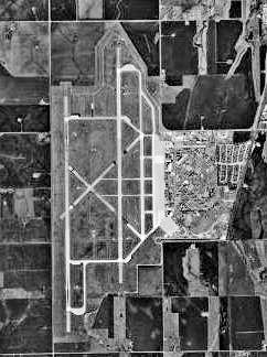 |
| USGS aerial image - February 19, 1995 |
| IATA: END – ICAO: KEND – FAA LID: END |
| Summary |
| Airport type |
Military: Air Force Base |
| Owner |
U.S. Air Force |
| Location |
Enid, Oklahoma |
| Built |
1941 |
| Occupants |
71st Flying Training Wing |
| Elevation AMSL |
1,307 ft / 398 m |
| Coordinates |
36°20′22″N 097°55′02″W / 36.33944°N 97.91722°W / 36.33944; -97.91722 |
| Website |
www.vance.af.mil |
| Runways |
| Direction |
Length |
Surface |
| ft |
m |
| 17R/35L |
9,202 |
2,805 |
PEM |
| 17C/35C |
9,202 |
2,805 |
PEM |
| 17L/35R |
5,024 |
1,531 |
Concrete |
| Source: Federal Aviation Administration |
 | |
71st Flying Training Wing Emblem |
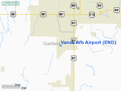
Vance Air Force Base (IATA: END, ICAO: KEND, FAA LID: END) is a United States Air Force base located 6 km (three nautical miles) south of downtown Enid, Oklahoma, and within its city limits, about 104 km (65 miles) north northwest of Oklahoma City. The base is named after local World War II hero and Medal of Honor recipient, Lt Col Leon Robert Vance Jr.
The host unit at Vance is the 71st Flying Training Wing (71 FTW), which is a part of Air Education and Training Command's (AETC) Nineteenth Air Force (19 AF). The commander of the 71 FTW is Colonel Russell L. Mack. The vice-commander is Colonel Roger J. Witek and the command chief is Chief Master Sergeant Mitchell K. Balutski. Mission
The 71st Flying Training Wing aims to train world-class pilots for the United States Air Force, Navy, Marine Corps, and its Allies and to prepare Air Expeditionary Force (AEF) warriors to deploy in support of the combatant commanders.
Units
The 71st Flying Training Wing consists of three subordinate groups:
- 71st Operations Group (71 OG) Tail Code "VN"
T-38 Talon, T-1 Jayhawk, T-6 Texan II
- 3d Fighter Training Squadron, AT-38C
- 5th Flying Training Squadron, T-38C, T-6, T-1A, AT-38C
- 8th Flying Training Squadron, T-6A
- 25th Flying Training Squadron, T-38C
- 32d Flying Training Squadron, T-1A
- 33d Flying Training Squadron, T-6A
- 71st Operations Support Squadron
- 71st Mission Support Group
- 71st Medical Group
History
Major Commands
- Gulf Coast Air Corps Training Cen, December 18, 1941 – January 23, 1942
- Air Corps Flying Training Comd, January 23, 1942 – March 15, 1942
- AAF Flying Training Comd, March 15, 1942 – July 31, 1943
- AAF Training Comd, July 31, 1943 – July 1, 1946
- Air Training Command, July 1, 1946 – July 1, 1993
- Air Education and Training Command, July 1, 1993 – present
Base operating units
- 80th Air Base Sq, November 29, 1941 – June 13, 1942
- 80th Base HQ and Air Base Sq, June 13, 1942 – May 1, 1944
- 2518th AAF Base Unit (Pilot School, Basic), May 1, 1944 – February 4, 1945
- 2518th AAF Base Unit [Pilot School, Advanced-2E], February 4, 1945 – September 26, 1947
- 2518th AF Base Unit, September 26, 1947 – August 26, 1948
- 3575th Air Base Gp, August 26, 1948 – November 1, 1972
- 71st Air Base Gp, November 1, 1972 – present
Major units assigned
 | |
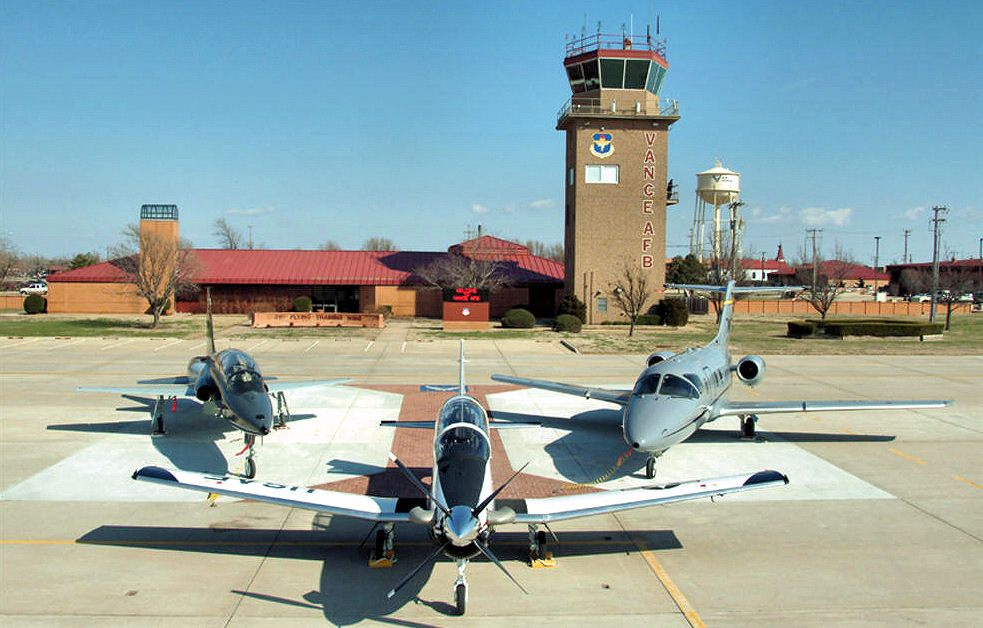
Aircraft of the 71st Flying Training Wing. From left: A T-38 Talon, T-6A Texan II, and a T-1 Jayhawk are posed in front of the base control tower on the Vance flightline. |
- 60th Air Base Group November 29, 1941 – December 20, 1942
- 31st Flight Training Wing January 16, 1943 – May 15, 1945
- 2518th Army Air Force/Air Force Base Unit May 1, 1944 – August 28, 1948
- 3575 Pilot Training Wing August 26, 1948 – November 1, 1972
- 8600 Pilot Training Wing June 27, 1949 – May 28, 1951
- 71st Flying Training Wing November 1, 1972 – present
Operational history
World War II
Construction began on 12 July 1941 for a cost of $4,034,583. Army Air Corps Project Officer, Major Henry W. Dorr supervised the construction and developed the basic pilot training base. In 1941, for the sum of $1 a year, this land was leased from the city of Enid to the federal government as a site for a pilot training field, and on November 21 the base was officially activated. The installation was without a name but was generally referred to as Air Corps Basic Flying School. The mission of the school was to train aviation cadets to become aircraft pilots and commissioned officers in the United States Army Air Forces.
The facility was assigned to the AAF Gulf Coast Training Center, with the Army Air Force Pilot School (Primary) activated (phase 1 pilot training), in which flight cadets were taught basic flight using two-seater training aircraft. Fairchild PT-19s were the primary trainer used.
It was not until 1942, that the base was officially named Enid Army Flying School, also known as Woodring Field. It was officially activated on 11 February 1942. On 8 January 1943, the War Department constituted and activated the 31st Flying Training Wing (Primary) at Enid and assigned it to the the AAF Central Flying Training Command. For the duration of the war, the basic phase of training graduated 8,169 students, while the advanced phase of training graduated 826.
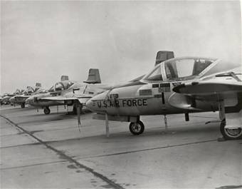 | |
T-37s at Vance Air Force Base in 1971. |
As the demand for pilots decreased with the end of the war in Europe, the Enid Army Flying Field was deactivated on 2 July 1945 and was transferred to the Army Corps of Engineers on 2 July 1946.
Cold War
 | |
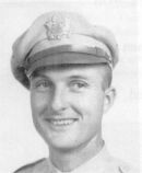
Lt. Col Leon Vance, Medal of Honor recipient. |
The base was reactivated on January 13, 1948, and its name changed to Enid Air Force Base, as one of the pilot training bases within the Air Training Command (ATC). Its mission was to provide training for advanced students in multi-engine aircraft.
In keeping with the Air Force tradition of naming bases for deceased Air Force flyers, on July 9, 1949, the base was renamed after a local World War II hero and Medal of Honor recipient, Lt Col Leon Robert Vance, Jr.
 | |
T-38A Talons of the 25th FTS at Vance AFB in November 1997. |
The first aircraft flown at Vance was the BT-13A, followed shortly by the BT-15. In 1944, advanced students flew the TB-25 and TB-26. Following the establishment of U.S. Air Force as a separate service in September 1947, Vance began training in the AT-6 and eventually the T-33 Shooting Star. The T-37 Tweet flew at Vance beginning in 1961, and the T-38 Talon in 1963 as the Air Force transitioned to its Undergraduate Pilot Training (UPT) system.
Post Cold War
In 1995 Air Force officials announced that Vance would transition to the Specialized Undergraduate Pilot Training curriculum. Under SUPT, Vance students begin their training in the T-37 Tweet, followed by the T-1A Jayhawk for students identified for jet tanker, transport or large reconnaissance aircraft, and the T-38 Talon for fighter, bomber and other USAF fixed-wing aircraft. With the introduction of the Joint Primary Aircraft Training System (JPATS) to Vance in 2005, the 71 FTW began transitioning from the T-37 to the newer T-6 Texan II. Joint training with the United States Navy began at Vance in 1996, with select USN and USMC strike jet student naval aviators obtaining all training at Vance except for carrier qualification, which they subsequently complete in the T-45 Goshawk at NAS Meridian, Mississippi or NAS Kingsville, Texas. A number of senior naval aviators in the rank of commander have also served as flying training squadron (FTS) commanders in the 71 FTW. Students practice basic patterns and landings at Kegelman Air Force Auxiliary Field located near Cherokee, Oklahoma. Vance is considered the second busiest RAPCON facility in the United States, behind Nellis AFB. Nellis is open 24 hours, but Vance has more traffic per hour.
The above content comes from Wikipedia and is published under free licenses – click here to read more.
Location & QuickFacts
| FAA Information Effective: | 2008-09-25 |
| Airport Identifier: | END |
| Airport Status: | Operational |
| Longitude/Latitude: | 097-55-02.2440W/36-20-22.3092N
-97.917290/36.339530 (Estimated) |
| Elevation: | 1307 ft / 398.37 m (Surveyed) |
| Land: | 0 acres |
| From nearest city: | 3 nautical miles S of Enid, OK |
| Location: | Garfield County, OK |
| Magnetic Variation: | 05E (1985) |
Owner & Manager
| Ownership: | Air Force owned |
| Owner: | U.s. Air Force |
| Address: | 71st Flt Trng Wg Vance Afb
Enid, OK 73701 |
| Manager: | Chief Airfield Management |
| Address: | 71st Flt Trng Wg Vance Afb
Enid, OK 73701 |
| Phone number: | 405-237-7424 |
Airport Operations and Facilities
| Airport Use: | Private |
| Wind indicator: | Yes |
| Segmented Circle: | No |
| Control Tower: | Yes |
| Lighting Schedule: | DUSK-DAWN |
| Beacon Color: | Clear-Green (lighted land airport) |
| Sectional chart: | Wichita |
| Region: | ASW - Southwest |
| Boundary ARTCC: | ZKC - Kansas City |
| Tie-in FSS: | MLC - Mc Alester |
| FSS on Airport: | No |
| FSS Toll Free: | 1-800-WX-BRIEF |
| NOTAMs Facility: | MLC (NOTAM-d service avaliable) |
Airport Services
| Fuel available: | B+ |
| Airframe Repair: | MAJOR |
| Power Plant Repair: | MAJOR |
| Bottled Oxygen: | LOW |
| Bulk Oxygen: | LOW |
Runway Information
Runway 13/31
| Dimension: | 4971 x 150 ft / 1515.2 x 45.7 m |
| Surface: | PEM,
FIRST 1300' RWY 17R AND FIRST 3900' RWY 35L IS CONC, MIDDLE 4000' IS ASPHALT. |
| Pavement Class: | 16 /R/C/W/T |
| Weight Limit: | Single wheel: 48000 lbs.
Dual wheel: 103000 lbs.
Dual tandem wheel: 232000 lbs.
Dual dual tandem wheel: 602000 lbs. |
| |
Runway 13 |
Runway 31 |
| Longitude: | 097-55-27.2110W | 097-54-39.2100W |
| Latitude: | 36-20-37.1220N | 36-19-58.1230N |
| Elevation: | 1293.00 ft | 1284.00 ft |
| Alignment: | 127 | 127 |
| Traffic Pattern: | Left | Left |
| Markings: | Nonstandard, Good Condition | Nonstandard, Good Condition |
| Runway End Identifier: | No | No |
| Centerline Lights: | No | No |
| Touchdown Lights: | No | No |
|
Runway 17C/35C
| Dimension: | 9202 x 150 ft / 2804.8 x 45.7 m |
| Surface: | PEM,
FIRST 1300' RWY 17R AND FIRST 3900' RWY 35L IS CONC, MIDDLE 4000' IS ASPHALT. |
| Surface Treatment: | Saw-cut or plastic Grooved
FIRST 3350' RWY 17C AND FIRST 1000' RWY 35C IS GROOVED CONC, MIDDLE 4950' IS GROOVED ASPHALT.
MIDDLE 2000' IS GROOVED. |
| Pavement Class: | 23 /R/C/W/T |
| Weight Limit: | Single wheel: 50000 lbs.
Dual tandem wheel: 298000 lbs.
Dual dual tandem wheel: 762000 lbs. |
| Edge Lights: | High |
| |
Runway 17C |
Runway 35C |
| Longitude: | 097-54-52.7700W | 097-54-52.8300W |
| Latitude: | 36-21-19.9200N | 36-19-48.9300N |
| Elevation: | 1276.00 ft | 1293.00 ft |
| Alignment: | 127 | 127 |
| ILS Type: | LOC/GS
| ILS
|
| Traffic Pattern: | Left | Left |
| Markings: | Precision instrument, Good Condition | Precision instrument, Good Condition |
| VASI: | 4-light PAPI on left side | 4-light PAPI on left side |
| Approach lights: | SALSF | SALSF |
| Runway End Identifier: | No | No |
| Centerline Lights: | No | No |
| Touchdown Lights: | No | No |
|
Runway 17L/35R
| Dimension: | 5024 x 150 ft / 1531.3 x 45.7 m |
| Surface: | CONC,
FIRST 1300' RWY 17R AND FIRST 3900' RWY 35L IS CONC, MIDDLE 4000' IS ASPHALT. |
| Surface Treatment: | Saw-cut or plastic Grooved
FIRST 3350' RWY 17C AND FIRST 1000' RWY 35C IS GROOVED CONC, MIDDLE 4950' IS GROOVED ASPHALT.
MIDDLE 2000' IS GROOVED. |
| Pavement Class: | 28 /R/C/W/T |
| Weight Limit: | Dual tandem wheel: 344000 lbs. |
| Edge Lights: | Medium |
| |
Runway 17L |
Runway 35R |
| Longitude: | 097-54-39.6400W | 097-54-39.6700W |
| Latitude: | 36-20-49.0500N | 36-19-59.3600N |
| Elevation: | 1273.00 ft | 1284.00 ft |
| Alignment: | 127 | 127 |
| Traffic Pattern: | Left | Left |
| Markings: | Nonstandard, Good Condition | Nonstandard, Good Condition |
| Runway End Identifier: | Yes | |
| Centerline Lights: | No | No |
| Touchdown Lights: | No | No |
|
Runway 17R/35L
| Dimension: | 9202 x 150 ft / 2804.8 x 45.7 m |
| Surface: | PEM,
FIRST 1300' RWY 17R AND FIRST 3900' RWY 35L IS CONC, MIDDLE 4000' IS ASPHALT. |
| Pavement Class: | 27 /R/C/W/T |
| Weight Limit: | Dual tandem wheel: 343000 lbs. |
| Edge Lights: | High |
| |
Runway 17R |
Runway 35L |
| Longitude: | 097-55-23.4800W | 097-55-23.5200W |
| Latitude: | 36-20-57.1900N | 36-19-26.1900N |
| Elevation: | 1275.00 ft | 1307.00 ft |
| Alignment: | 127 | 127 |
| Traffic Pattern: | Left | Left |
| Markings: | Precision instrument, Good Condition | Precision instrument, Good Condition |
| VASI: | 4-light PAPI on left side | 4-light PAPI on left side |
| RVR Equipment: | | touchdown |
| Approach lights: | SALS | SALS |
| Runway End Identifier: | No | No |
| Centerline Lights: | No | No |
| Touchdown Lights: | No | No |
|
Radio Navigation Aids
| ID |
Type |
Name |
Ch |
Freq |
Var |
Dist |
| FAU | NDB | Fairview | | 246.00 | 07E | 27.4 nm |
| JWG | NDB | Watonga | | 359.00 | 07E | 37.9 nm |
| LCY | NDB | Logan County | | 326.00 | 07E | 38.4 nm |
| AVK | NDB | Alva | | 203.00 | 08E | 45.0 nm |
| PN | NDB | Ponca | | 515.00 | 05E | 49.0 nm |
| ODG | VOR/DME | Woodring | 027X | 109.00 | 08E | 6.6 nm |
| SWO | VOR/DME | Stillwater | 021X | 108.40 | 07E | 41.1 nm |
| END | VORTAC | Vance | 101X | 115.40 | 09E | 0.4 nm |
| IFI | VORTAC | Kingfisher | 094X | 114.70 | 09E | 32.4 nm |
| PER | VORTAC | Pioneer | 079X | 113.20 | 06E | 44.0 nm |
Remarks
- RSTD: OVERHEAD APCH TO RWY 17C-35C NOT AUTH FOR TRAN ACFT DUR STU TRNG OPR.
- BEARING STRENGTH RWY 04-22: ST127 SBTT379 DDT547.
- BEARING STRENGTH RWY 13-31: ST172 SBTT525 DDT740 TRT345.
- BEARING STRENGTH RWY 17L-35R: TRT544.
- BEARING STRENGTH RWY 17R-35L: TRT540.
- BEARING STRENGTH RWY 17C-35C: SBTT535 DDT790 TRT469.
- A-GEAR: RWY 17C BAK-15 CHAG (154' OVRN).
- A-GEAR: RWY 35C BAK-15 CHAG (147' OVRN).
- A-GEAR: RWY 17R BAK-15 CHAG (152' OVRN).
- A-GEAR: RWY 35L BAK-15 CHAG (149' OVRN).
- MISC: BASE OPS DSN 448-7425, C580-213-7425.
- RSTD: DUR STU TRNG TRAN ACFT LTD TO ONE FULL STOP LDG.
- MISC: ACFT CARRYING DV CODE 7 OR HI CTC VANCE OPS 20 MIN PRIOR TO ETA.
- MISC: CLASS D AIRSPACE EFF DURING PUBLISHED OR NOTAMED AIRFIELD HRS, OT CLASS E.
- MISC: WX OBSN LTD ALL QUAD DUE BLDG, HGR, SHELTERS AND ACFT OBST VIEW. ALL EOR NOT VIS FR OBSN PT. WHEN FOG AND/OR LO CLOUDS PRESENT OVER APCH END OF RWY 17-35 COND RPT FR THE OBSN PT MAY NOT BE REPRESENTATIVE.
- SEE FLIP AP/1 SUPPLEMENTARY ARPT RMK.
- JASU: 8(A/M32A-86) 10(AM32-95).
- FUEL: J8.
- FLUID: SP PRESAIR LPOX LOX.
- OIL: O- 133-148-156 SOAP.
- TRAN ALERT: NO FLEET SVC AVBL.
- A-GEAR: BAK-15 IS IN LO POSN UNLESS REQ BY PILOT TO BE RAISED. BAK-15 IS 24' HI WHEN RAISED. PILOT SHOULD CONFIRM WITH TWR THAT BARRIER IS LO PRIOR TO OPPOSITE DRCT APCH.
- APPROACH LIGHTING SYSTEM RWY 17C/35C NON-STANDARD (SALS INSTALLED ON PRECISION RUNWAY).
- CAUTION: PORTIONS PARL TWY, TO INCL RWY 17L-35R APCH END HOT BRAKE AREA, NOT VIS FR TWR.
- RSTD: ONY T-37, T-38, T-6 AND T-1 ACFT WILL USE TXY F, EAST OF RWY 17C/35C WHEN RWY 17L/35L IS IN USE. ALL OTHER ACFT MUST USE TXY A, C, OR E.
- CAUTION:SOME OBST LGTS ON AFLD ARE NON-STANDARD AND ONLY VISIBLE TO 3 MILES.
- CAUTION: ACFT SUNSHADES 735' E OF RWY 17L/35R.
- CAUTION: BAK-15 BARRIER LAYS ACROSS THE APPROACH END OF RUNWAYS 17C/35C AND 17R/35L UNDERRUN. BARRIERS NOT CONNECTED TO ENERGY ABSORBER (CHAINS) AT APPROACH END OF ACTIVE RUNWAY.
- RSTD: DUR VMC, DEP ACFT MUST REMAIN BLW 2300' TIL PAST DEP END TO ENSURE SEPARATION FR VFR OVERHEAD TFC PAT UNLESS OTHERWISE CLEARED BY ATC.
- RSTD: PPR, CTC BASE OPS.
Images and information placed above are from
http://www.airport-data.com/airport/END/
We thank them for the data!
| General Info
|
| Country |
United States
|
| State |
OKLAHOMA
|
| FAA ID |
END
|
| Latitude |
36-20-23.360N
|
| Longitude |
097-54-58.610W
|
| Elevation |
1307 feet
|
| Near City |
ENID
|
We don't guarantee the information is fresh and accurate. The data may
be wrong or outdated.
For more up-to-date information please refer to other sources.
|
|