 |
|
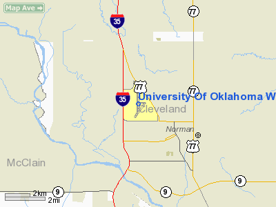
University Of Oklahoma Westheimer Airport |
University of Oklahoma
Max Westheimer Airport |
| IATA: OUN – ICAO: KOUN |
| Summary |
| Airport type |
Public |
| Operator |
University of Oklahoma |
| Location |
Norman, Oklahoma |
| Elevation AMSL |
1,182 ft / 360.3 m |
| Coordinates |
35°14′44.03″N 97°28′19.66″W / 35.2455639°N 97.4721278°W / 35.2455639; -97.4721278Coordinates: 35°14′44.03″N 97°28′19.66″W / 35.2455639°N 97.4721278°W / 35.2455639; -97.4721278 |
| Runways |
| Direction |
Length |
Surface |
| ft |
m |
| 17/35 |
5,200 |
1,585 |
Asphalt |
| 3/21 |
4,747 |
1,447 |
Asphalt |
| Statistics (2006) |
| Aircraft operations |
66,065 |
| Based aircraft |
99 |
University of Oklahoma Westheimer Airport (IATA: OUN, ICAO: KOUN), also known as Max Westheimer Airport, is a public general aviation airport located three miles (5 km) northwest of the city of Norman in Cleveland County, Oklahoma, USA. The airport is run by the University of Oklahoma. It was originally a US Navy flight training field, established in 1941, and was transferred to the University after the war .
Facilities
University of Oklahoma Westheimer Airport covers 725 acres (293 ha) and has two runways:
- Runway 17/35: 5,200 x 100 ft. (1,585 x 30 m), Surface: Asphalt
- Runway 3/21: 4,747 x 100 ft. (1,447 x 30 m), Surface: Asphalt
The above content comes from Wikipedia and is published under free licenses – click here to read more.
Location & QuickFacts
| FAA Information Effective: | 2008-09-25 |
| Airport Identifier: | OUN |
| Airport Status: | Operational |
| Longitude/Latitude: | 097-28-19.6630W/35-14-44.0320N
-97.472129/35.245564 (Estimated) |
| Elevation: | 1182 ft / 360.27 m (Surveyed) |
| Land: | 727 acres |
| From nearest city: | 3 nautical miles NW of Norman, OK |
| Location: | Cleveland County, OK |
| Magnetic Variation: | 07E (1985) |
Owner & Manager
| Ownership: | Publicly owned |
| Owner: | Univ Of Oklahoma |
| Address: | 1700 Lexington Ave
Norman, OK 73069 |
| Phone number: | 405-325-7233 |
| Manager: | Walt Strong |
| Address: | 1700 Lexington Ave
Norman, OK 73069 |
| Phone number: | 405-325-7233 |
Airport Operations and Facilities
| Airport Use: | Open to public |
| Wind indicator: | Yes |
| Segmented Circle: | Yes |
| Control Tower: | Yes |
| Lighting Schedule: | DUSK-DAWN
WHEN ATCT CLSD MIRL RYS 03/21 & 17/35; MALSR RY 17 & MALS RY 03 PRESET MED INTST; TO INCR INTST ACTVT - CTAF. |
| Beacon Color: | Clear-Green (lighted land airport) |
| Landing fee charge: | No |
| Sectional chart: | Dallas-ft Worth |
| Region: | ASW - Southwest |
| Traffic Pattern Alt: | 1000 ft |
| Boundary ARTCC: | ZFW - Fort Worth |
| Tie-in FSS: | MLC - Mc Alester |
| FSS on Airport: | No |
| FSS Toll Free: | 1-800-WX-BRIEF |
| NOTAMs Facility: | OUN (NOTAM-d service avaliable) |
| Federal Agreements: | NGPVY |
Airport Communications
| CTAF: | 118.000 |
| Unicom: | 122.950 |
Airport Services
| Fuel available: | 100LLA |
| Airframe Repair: | MAJOR |
| Power Plant Repair: | MAJOR |
Runway Information
Runway 03/21
| Dimension: | 4747 x 100 ft / 1446.9 x 30.5 m |
| Surface: | ASPH, Good Condition |
| Weight Limit: | Single wheel: 30000 lbs.
Dual wheel: 50000 lbs.
Dual tandem wheel: 100000 lbs. |
| Edge Lights: | Medium |
| |
Runway 03 |
Runway 21 |
| Longitude: | 097-28-32.8830W | 097-27-59.0650W |
| Latitude: | 35-14-10.3770N | 35-14-48.2510N |
| Elevation: | 1175.00 ft | 1179.00 ft |
| Alignment: | 36 | 127 |
| ILS Type: | LOC/DME
| |
| Traffic Pattern: | Left | Right |
| Markings: | Non-precision instrument, Good Condition | Non-precision instrument, Good Condition |
| Crossing Height: | 30.00 ft | 32.00 ft |
| VASI: | 2-box on left side
VASI OTS INDEFLY. | 2-box on left side |
| Visual Glide Angle: | 3.50° | 3.50° |
| Approach lights: | MALS | |
| Obstruction: | 35 ft pole, 1400.0 ft from runway, 30 ft left of centerline, 34:1 slope to clear | 57 ft ant, 1430.0 ft from runway, 400 ft left of centerline, 21:1 slope to clear |
|
Runway 17/35
| Dimension: | 5200 x 100 ft / 1585.0 x 30.5 m |
| Surface: | ASPH, Good Condition |
| Weight Limit: | Single wheel: 30000 lbs.
Dual wheel: 50000 lbs.
Dual tandem wheel: 100000 lbs. |
| Edge Lights: | Medium |
| |
Runway 17 |
Runway 35 |
| Longitude: | 097-28-23.2170W | 097-28-22.8440W |
| Latitude: | 35-15-23.1820N | 35-14-31.7550N |
| Elevation: | 1181.00 ft | 1177.00 ft |
| Alignment: | 127 | 127 |
| ILS Type: | ILS/DME
| |
| Traffic Pattern: | Right | Left |
| Markings: | Precision instrument, Good Condition | Non-precision instrument, Good Condition |
| Crossing Height: | 33.00 ft | 47.00 ft |
| VASI: | 2-box on left side
VASI OTS INDEFLY. | 2-box on left side
VASI OTS INDEFLY. |
| Visual Glide Angle: | 3.50° | 3.50° |
| Approach lights: | MALSR | |
| Runway End Identifier: | | Yes |
|
Radio Navigation Aids
| ID |
Type |
Name |
Ch |
Freq |
Var |
Dist |
| OUN | NDB | Norman | | 260.00 | 07E | 0.2 nm |
| OK | NDB | Tuloo | | 406.00 | 07E | 15.1 nm |
| OLR | NDB | Chickasha | | 290.00 | 07E | 26.0 nm |
| RQO | NDB | El Reno | | 335.00 | 07E | 29.8 nm |
| PVJ | NDB | Pauls Valley | | 384.00 | 06E | 34.0 nm |
| LCY | NDB | Logan County | | 326.00 | 07E | 36.2 nm |
| SRE | NDB | Seminole | | 278.00 | 06E | 39.2 nm |
| GGU | NDB | Prague | | 314.00 | 06E | 40.4 nm |
| CQB | NDB | Tilghman | | 396.00 | 06E | 42.9 nm |
| TIK | TACAN | Tinker | 105X | | 07E | 12.3 nm |
| PWA | VOR/DME | Wiley Post | 081X | 113.40 | 08E | 19.3 nm |
| ADH | VOR/DME | Ada | 125X | 117.80 | 06E | 47.6 nm |
| IRW | VORTAC | Will Rogers | 088X | 114.10 | 07E | 9.6 nm |
| IFI | VORTAC | Kingfisher | 094X | 114.70 | 09E | 42.5 nm |
| OKC | VOT | Oklahoma Will Rgs W | | 108.80 | | 10.9 nm |
Remarks
- 180 DEG TURNS PROHIBITED ON RWYS FOR ALL OTHER THAN SINGLE ENGINE LIGHT ACFT.
- TPA FOR HELS 500 FT AGL; SINGLE ENGINE 1000 FT AGL; MULTI-ENGINE & JETS 1500 FT AGL.
- USE EXTREME CARE COYOTES & DEER ON & INVOF OF RYS.
- HIGH DENSITY STUDENT OPNS INVOF ARPT & 5 MILES SOUTH.
- PREFERRED CALM WIND RY: ARR RYS 03 & 17 DEP RYS 21 & 35.
- PRE DATES THE ACT.
Images and information placed above are from
http://www.airport-data.com/airport/OUN/
We thank them for the data!
| General Info
|
| Country |
United States
|
| State |
OKLAHOMA
|
| FAA ID |
OUN
|
| Latitude |
35-14-44.032N
|
| Longitude |
097-28-19.663W
|
| Elevation |
1182 feet
|
| Near City |
NORMAN
|
We don't guarantee the information is fresh and accurate. The data may
be wrong or outdated.
For more up-to-date information please refer to other sources.
|
|


